| Peak(s): |
Ben Nevis - 4409 Ben Lomond - 3196 Bruach na Frìthe - 3134 |
| Date Posted: | 05/29/2013 |
| Date Climbed: | 05/23/2013 |
| Author: | Zambo |
| Peak(s): |
Ben Nevis - 4409 Ben Lomond - 3196 Bruach na Frìthe - 3134 |
| Date Posted: | 05/29/2013 |
| Date Climbed: | 05/23/2013 |
| Author: | Zambo |
| Chasing Munros - Climbing the Scottish Highlands |
|---|
|
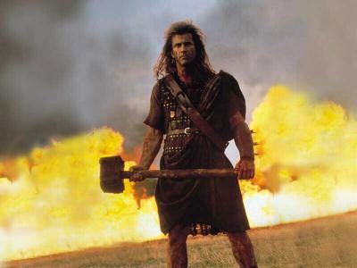
Farewell to the Highlands, farewell to the North, The birth-place of Valour, the country of Worth; Wherever I wander, wherever I rove, The hills of the Highlands for ever I love. -Robert Burns, National Poet of Scotland Chasing Munros - Climbing the Scottish HighlandsPerhaps more than any other country on earth, I have always been enchanted by Scotland. Prior to this trip, I did not understand exactly why. Maybe it was my family heritage and curiosity about my ancestors which called to me. Or perhaps it was an interest born from seeing countless photos and movies of amazing castles, green hills, and epic landscapes in the Highlands. Or maybe it was simply the 'typical' things one thinks about in regards to Scotland - kilts, bagpipes, green mountains, sheep, rain.... Whatever the reason, this was a place to which I always knew I must go. Now, upon travelling there and returning home, the allure is none the weaker. No, three weeks on the misty isle has only served to captivate me all the more. Except now the fascination is founded on experience and loving memory, rather than curiosity and intrigue. I now realize that is was not one singular thing which enticed me, rather it is everything which the country has to offer. This island is a treasure. From the ground to the clouds, the sea to the hills, and everything in between, the entirety of the country and its mountains is a place which enchants like nowhere else. 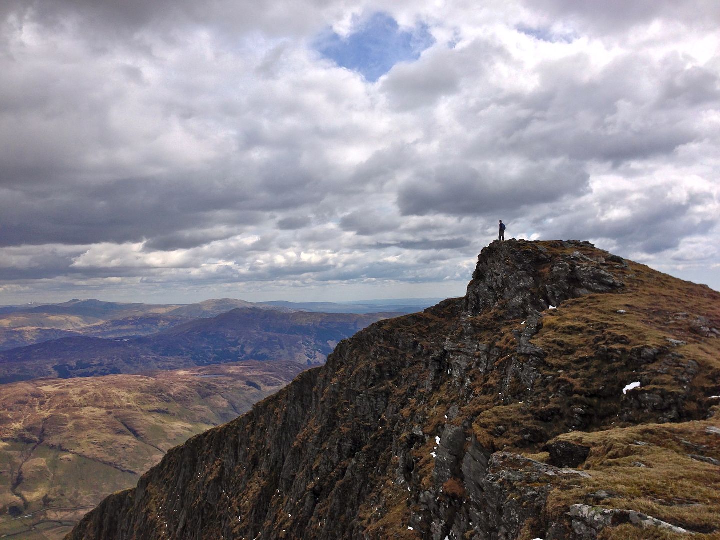 Scotland's Highest Peaks - The Mythical MunrosFor us, the dream continues... Fresh off of trekking in Patagonia, my wife and I got a quick five day respite in Denver to do a bit of R&R, swap out some gear, and plan the next leg of our three month travels. Thankful to ditch the tent, sleeping pads, and camp gear, we were keen to do less camping and a bit more 'civilized' travel this time around (ie: Hostels instead of tents. Although frankly, I think half the time I'd prefer the tent...). Coming off of two weeks in Spain and a week in Switzerland (that country is worthy of its own TR...) we found ourselves on a plane headed to Edinburgh for the final stop in our journey. There are many, many good reasons to go to Scotland, not the least of which for us was the chance to climb and trek in the Highlands. I had been to the UK a few times before this trip, but never made it outside of England and Wales. Don't get me wrong, England is an amazing place, but each time I left I had a very palpable sense of regret at not getting to go north. I always regretted it. However, not this time around. This time we resolved to spend a solid three weeks in Scotland proper and see and do all that we could. And of course, for a good chunk of the journey, that means mountains. As most probably know, Scotland is a country divided (roughly) in half between the southern Lowlands and the Highlands to the north. The Lowlands contain the vast majority of the population, settlements, and economy. They are beautiful by their own rite. In many ways the landscape here resembles a simple continuation of the English countryside (but don't let a Scot hear you say that). Quaint villages, rolling green pastures, stone houses, and little streams & rivers abound. It is all quite idyllic and one can't help but be reminded of 'The Shire' at every new twist or turn in the road. Yes, the Lowlands are very appealing and charming in their own way. But the heartbeat of the country undoubtedly lies in the north. From both a sense of history and landscape, the Highlands are the foundations upon which the rest of the country sits. From a historical point of view, this is the site of countless rebellions, kingdoms, religious struggles, battles, towns & villages, and a breadth history which puts our own to shame. For thousands of years the Scots (and the Picts before them) have lived, worked, fought, bled and died here. It is a historical legacy which is as deep as it is fascinating, as rich as it is tragic. Of course, this history has also left its mark on the hills. People have always interacted and adapted to the lands in which they live. But I think the mountains and landscapes of Scotland are intertwined in a very unique and unmistakable way. Everywhere you go you are, quite literally, walking in, on, and around history. Old stone houses, ancient pathways, historical sites and crumbling castles abound. The people of the land have adapted to it, cultivated it, and lived in its good graces for centuries. The whole time I couldn't help but feel that I was treading on something far older, wiser, and more ancient then me. I suppose every mountain is like this when you really think about it, but in Scotland somehow you just seem to feel it all the more. I could not shake the sense that these mountains have a story to be told. When taking the time to listen and reflect on this, it was quite humbling. Suffice it to say, between the history and the stunning backdrop, I think it fair to say that the collective culture, pride, and consciousness of the nation rests in these hills. Now...all of my musings aside, let's talk about some peaks. The prize in Scotland is to walk, hike, and (sometimes) climb up The Munros. The Munros are the 282 mountains which rise at least 3,000 feet above the sea (a LOJ'ers dream...). We Coloradans may scoff at such paltry elevations, but what these peaks lack in absolute elevation, they make up for in some other very powerful ways. To start, you must consider that essentially every Munro starts at approximately 0-500 feet. Keeping this in mind, the size of the mountains becomes rather more impressive - easily as prominent as many of the 14ers in our own backyard. The northerly geography also adds to their resume, as the winters here can be quite harsh - filled with deep snows and epic sea winds coming off of the Atlantic. Another unique challenge from the sea is the (usually) downright terrible weather. Rain, fog, and a near impenetrable mist is a constant here. While we might be tempted to shrug off the idea of always using a compass (I know I rarely do), for a Scot this is a necessity. Navigating in a fog or rain with less than 30 feet of visibility is a real possibility, making good navigation skills essential. As they say, "If it's not raining, it will be raining." However, despite the low elevations and high rainfall, surprisingly, the tree line here is very, very low, making exposure that much more of a factor. And if that is not enough, one final thing remains: the bogs. All of that rain leaves the plains as essentially one massive sponge of boggy wetness, mud, and bugs. Most of the more popular peaks have excellent paths, but a misstep of only a few feet will more often than not leave a hiker with a wet mud-soaked boot for the rest of the day. The mountaineering mindset of the Munros is fascinating as well. I only got a small taste, but in reading and talking with all the local we met on trail, I got the very keen sense of just how similar the Munro culture is to 14ering. So many aspects are similar: there are the 'classic' popular gaper-infested mountains, there is the challenge to climb all the peaks and (of course) the endless debate on the merits of lists, there is the struggle of private vs. public land access, there is the challenge of conservation of the hills whilst simultaneously walking all over them, there is the ever present threat of tragedy as people lose their lives out here every year...there is even an established speed record to do all the summits (40 days). On the whole, this only further strengthened my conviction about the similarities of people which transcend country and culture. At the end of the day, we are all human and react to the most important things in remarkably similar ways. This was certainly evident here. Now, all that said, I certainly was not going to climb all 282 in three short weeks. In fact, reaching summits actually took a backseat to the simple pleasure of getting out and experiencing the country. That was the primary goal. Nevertheless, I managed to top out on three Munros mixed in with a number of other walks and treks we did. There is no need to recount every detail in full (I have written far too much already), but what follows are some of the images, memories, and reflections I had from those climbs.  An Introduction to Bogs, Lochs, and The Wild North - Ben Lomond (3,196')Location: Loch Lomond and the Trossachs National Park Distance: 17 miles Vertical Feet Climbed: 2,996' Ben Lomond ('Ben' means 'mount' in Gaelic) is the most southerly Munro, an hour north of Glasgow. The peak sits in the middle of Loch Lomond and the Trossachs National park - one of two national parks in Scotland. Loch Lomond is rather famous here. It is the largest lake (by area) in the country and close to the majority of the population. Its stunning beauty and size make it a very popular destination for Scots in the summer. Ben Lomond sits roughly half way on the loch, towering over it and all the surrounding hills. An easy and gentle walk to the top, it was the perfect way to cut my teeth on some Scottish hill walking. BELOW: Base camp (no joke). Long story...but we actually volunteered and stayed in a renovated 500 year old castle for a week right in the middle of the park. Close to the peak (approx 9 miles away) one of my fellow volunteers and I set off early in the morning for our shot at the summit.  Reaching the lower trail, we ditched the bikes and set off into the woods. Now, the standard route up this peak is a perfectly nice, smooth, graded trail the whole way. In the absolute worst of circumstances, the trail would never fail you. However, seeing as we were approaching from the other side (and using a topo map from 1994) the connecting trail we found was quite a different story. The 'trail' consisted of a boggy bushwhack of epic proportions. Guided only by some feint old marker posts, and the knowledge that this had to be a trail at some point in the past, we naively and optimistically jumped right in. Almost immediately we were hit with the totality and reality of a Scottish bog. What that means is that essentially the entire ground is a water-saturated mud-pit just waiting to eat your boots and ruin your day. Careful steps are paramount here as each needs to be tested for solid ground, of which there seems to be none. I have never wanted gaiters more in my entire life. But it was not actually as bad as I make it out to be. In fact, to an extent, this radically new change of hiking terrain was a bit refreshing (sometimes literally) as we slogged up the 1/2 mile of river bog for the better part of an hour. It was certainly pretty.    Finally through the trees, we gained the prominent south ridge to meet the standard route for the remainder of the route. In reaching the ridge, my overwhelming realization was just how much I had underestimated the size of this peak. Falling for the 'lie' of low elevation, I had forgotten that 3,000 feet still takes quite a while to get up. Although, continually amazed at just how big this thing was, the views from the ridge easily erased any annoyances. They were nothing short of stunning.     Gaining the top was special. The weather was easily the best we had since arriving. Clear skies left visibility for miles and miles - a real treat. Every summit is pretty, but the cool thing about topping out here was that it was that it felt like the first real chance I got to 'see' the country. Travelling around in cars and trains is nice, but there is just no substitute for standing on top of something new, looking out into the distance, and really absorbing the landscape. Given that Ben Lomond is so far south, turing to the north was an amazing way to take in the miles and miles of mountains stretching out before us. This turned out to be the perfect intro and made me all the more excited to go further up and further in. BELOW: Summit Panorama and views from the top. 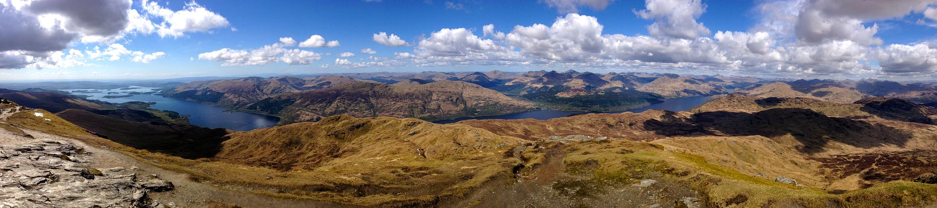 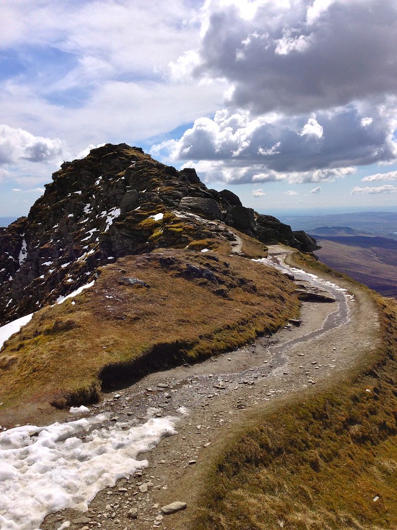 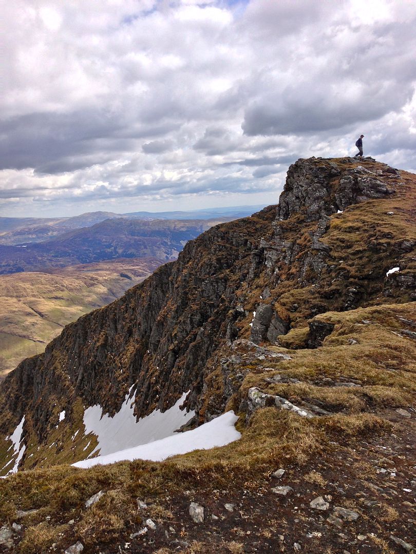 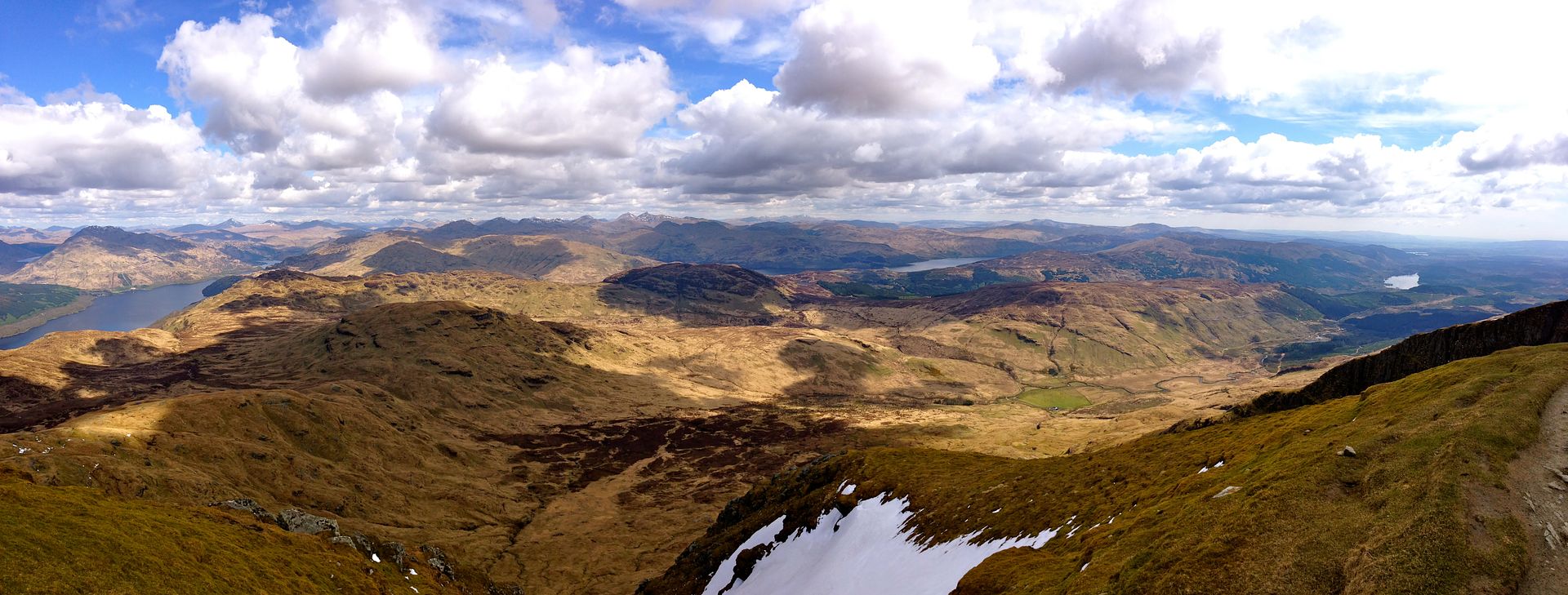 King of the Isles - Ben Nevis (4,409')Location: Ben Nevis Range Distance: 10 miles Vertical Feet Climbed: 4,375' Ben Nevis is the big smoke around these parts. This peak has what must be one of the richest, most comprehensive mountaineering histories of almost any mountain on earth. The Summit Post Page on the peak is as comprehensive as any other mountain out there - a solid 30-60 minute read alone. There are countless other books, websites, and blogs out there to supplement. As the reigning highpoint of the British Isles (this peak is every bit of its 4,409 ft. elevation), as well as one of the coolest profiles around, the mountain is well worthy of the crown which it wears. The main draw to Ben Nevis is obviously its height, but the mountain is so much more than just that. This is a peak of contrasts. While the southern and western aspects are quite gentle, the North Face is a different matter entirely. Nearly a mile long and encompassing over 2,000 vertical feet of drop, this alpine wall is worthy to be counted amongst some of the finest in the world. Primarily a winter playground, there are literally dozens and dozens (if not hundreds) of mountaineering, ice, mixed, and rock routes up the North Face. As such, Ben Nevis has served as the premier test-piece for British climbers for well over a century. In fact, British mountaineers in the Himalaya have been know to quip that nasty weather on places like Everest are "good training for Ben Nevis." The sentiment is only partly in jest. Just reading bits and pieces about the routes and complexities of it was extremely humbling. Add in the thousands of lay-folk folk who give the summit a go each year, and this peak has a climbing history like few others. As for me, well, I was not in any hurry to test out rock routes with out any prep or gear, but the 10 mile, 4,000+ vert on the standard route seemed like fun enough. Hooking up with another guy from the hostel keen to get on top, we set out early on what seemed to be the only feasable weather window for the next week.    , the views start to get a bit ridiculous.") The hike up was splendid. The weather cooperated for the first few hours and the views were out of this world. Essentially every stereotype and internal image I had of Scotland was confirmed here as we ascended. The rolling hills, green everywhere, hidden little lochs in the alpine...this was living. Also, one other very important Scottish stereotype was exercised: Braveheart. Now, for anyone else out there like me, I grew up on that movie. Say what you will about Mel Gibson, the historical inaccuracies, the sloppy editing, or the overall cheese-factor, but lets be honest: that shit is awesome. Equally awesome I have found (along with Benners and lordhelmut) is the practice of yelling out ridiculous Braveheart quotes at every opportunity on every single climb. As much as mtnfiend may utterly hate the practice, the rest of us think it is hilarious. Thus far in Scotland, climbing with new partners (and not wanting to come off like a mad man), I had been restricted to internalizing these quotes as we had tromped around. Well, imagine my utter delight and surprise when my partner that day at one point sheepishly turned to me a muttered a Braveheart quote. I could immediately tell he was testing the waters, waiting to see if I too, had ever felt this urge. I thought to myself, "My friend, you have no idea..." What followed was no small amount of hollering, yelling, movie-quoting and terrible Scottish ascents for the remainder of the climb. Being one of the first parties up that day, we took full advantage of our solitude and American-gaper status. As lordhelmut would put it later, "So we aren't the only assholes who mindlessly blurt that stuff out like primates in the mountains?" No Brian, no we are not. BELOW: Channelling that inner Wallace. 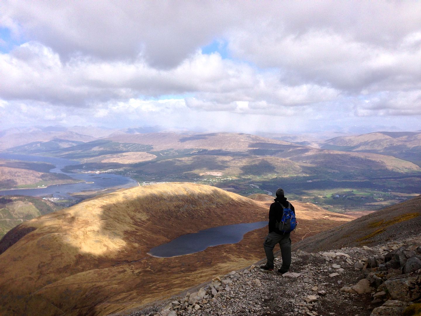 I mentioned all that nasty Scottish weather earlier. To this point we had been fortunate enough to have a great day out there. The clouds were above us as the route zig-zagged up some 3,000 feet, cutting its way through the grass in an unmistakable line. Three hours in, that was about to change. It is here that the route leaves the flanks of Ben Nevis and begins to arch onto its massive summit plateau. The plateau runs for nearly a mile and is a jumbled mess of skree and rocks en-route to the top. Navigation becomes tricky as the sheer North Face meets the plateau on one side, but the summit is not obvious. Also at this point two things happened: we finally reached snowline, and we entered the clouds. The original Gaelic name for Ben Nevis translates, "mountain with its head in the clouds" or, for the more poetically inclined, it is the "mountain of heaven." Whichever you prefer, we certainly got it on that day as the final thousand feet were socked in with a thick mist. The contrast of hiking directly into a cloud was fascinating to me as within the span on literally three minutes visibility went from near perfect to less than 50 feet. The good news, however, is that this is a regular occurrence. As such, the last stretch has massive cairns leading all the way to the top. BELOW: The beginnings of the cairns as they lead off into the mist. 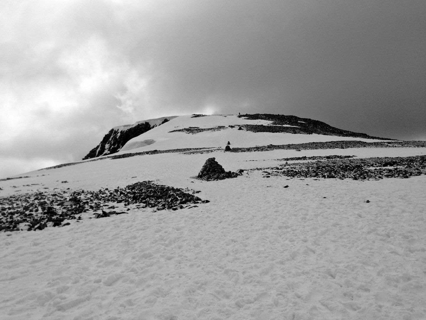   The summit views, frankly, were non existent. The cloud layer was such that we were socked in with no chance of seeing much further than what was right in front of us. A bit disappointing, but on the other hand, I reminded myself this is simply a fact of life for climbing Munros. Keeping in mind just how fortunate I was to even be here in the first place, we hunkered down and got some food to fuel up for the descent, increasingly realizing that this was becoming a winter experience. Stomachs full and hands frozen, we headed out after hanging for 30 minutes or so at the top.   Coming down called up more thoughts of Colorado as we passed a veritable cattle-train of people heading to the top. Thankful to have started early, I marveled at the number of people, as well as the scant gear many seemed to be carrying. Reminding myself that people are the same everywhere, I was quickly realizing that the standard route up Ben Nevis is the Quandary of Scotland. Ah well, it took nothing away from this day as I was simply joyful to have been blessed with such an awesome climb up a very special peak. Mountaineering the Isle of Skye - Bruach na Fr�the (3,134')Location: Cuillin Range, Isle of Skye Distance: 8 miles Vertical Feet Climbed: 2,974' One of our last destinations for the trip was the Isle of Skye. This island contains some of the most stunning scenery and landscapes in the whole country. Set apart from the main land by a half-mile long bridge, the Munros here rise some 3,500 feet nearly directly out of the sea. Skye is home to the Cuillin Range - a stretch of peaks famous for containing some of the most difficult and challenging climbing in the country. And that isn't just by Scotland standards - this is the main jaunt for mixed mountaineering, rock, and ice routes. Some of the summits here require mandatory rope work and fun scrambles abound. The bare rock, jagged and with steep cliffs, and deep cuts and gullies make this the only range in Scotland comparable to almost anything in the Rockies or the Alps. Our goal was a peak called Bruach na Fr�the (no idea how to pronounce that). This mountain is on the far end of the Cuillins Range and sits amongst some very prominent rock walls and spires nearby. Its Class 3 North Ridge Route is also the beginning of the Cuillins Traverse - a seven mile class 4 scramble which crosses the length of the range. Times on the traverse range from 10-20 hours, with 15 being the norm. Maybe someday... For us, we were happy to simply get up the beginnings of it for our final Munro. BELOW: Some of the sights and images of Skye. Before heading for the mountains, we were able to get in a few coastal walks in the area.     BELOW: Back to the mountains, Bruach na Fr�the is the center summit, as seen from the TH. 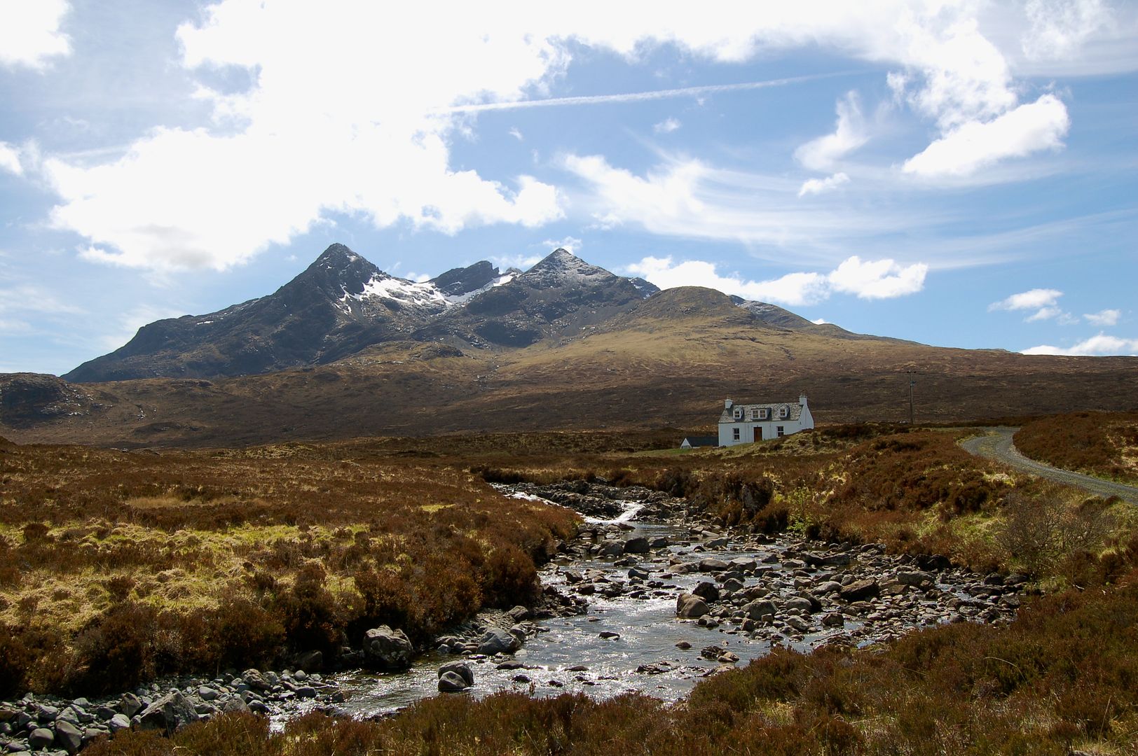   Enjoying a beautiful day of weather (albeit with more mist visible on the tops), we hiked some thee miles up to the lower flanks of the Cuillins. Pressed for time and with Katie feeling tired, this was a good chance for her to hang back as I would make an attempt at the ridge. From here, it was 1,400 ft to the top on what was rated a Scottish grade 1 scramble. Not entirely certain of the exact conversion or what that meant, I had some reservations on soloing it as a fresh blanket of snow was hanging to the higher ridge. But it certainly looked straightforward enough and another party could be seen near the summit. I decided to simply take it 50 feet at a time, and turn back at the first signs of any sketchiness. Enjoying the fullness of air at near sea level, I ditched the pack, gulped down some fluids, and tore up the ridge moving about as fast I can.     The climbing was actually pretty good. The lower ridge line was a simple hill climb, turning more scrambly higher up. Although snow was present, it was very thin and didn't really affect the holds or rock in too negative of a way. To top it off, the rock was solid and the exposure actually pretty relaxed. Overall I would probably call it a soft class 3 at best, which was great considering the excellent views offering a near constant distraction. 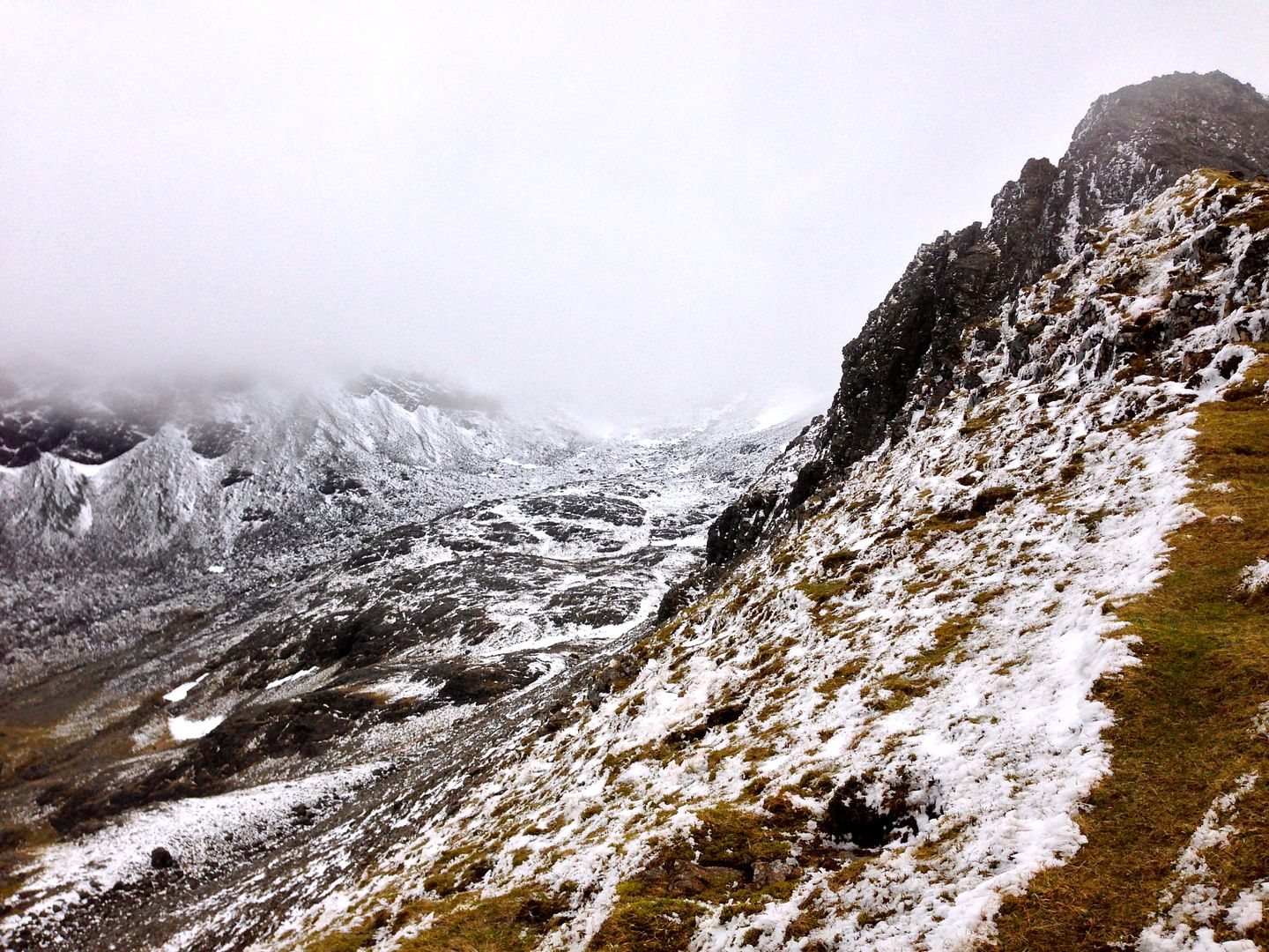 BELOW: Passing snow line and looking back down at the route. 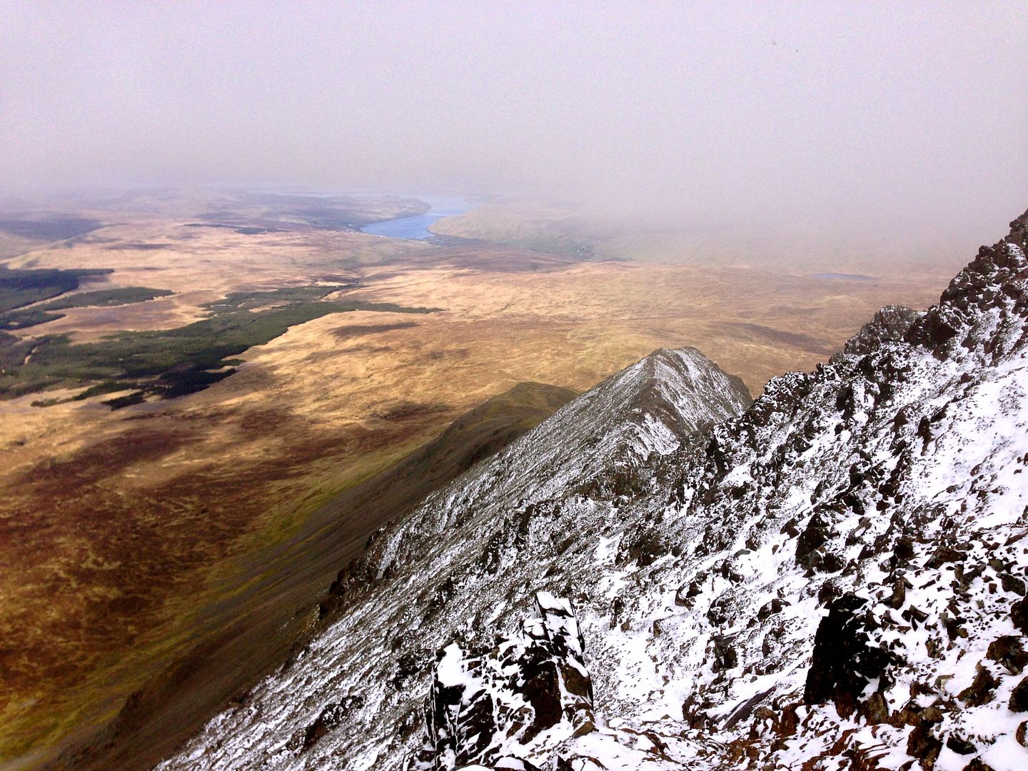 BELOW:The remainder of the range off to the west. 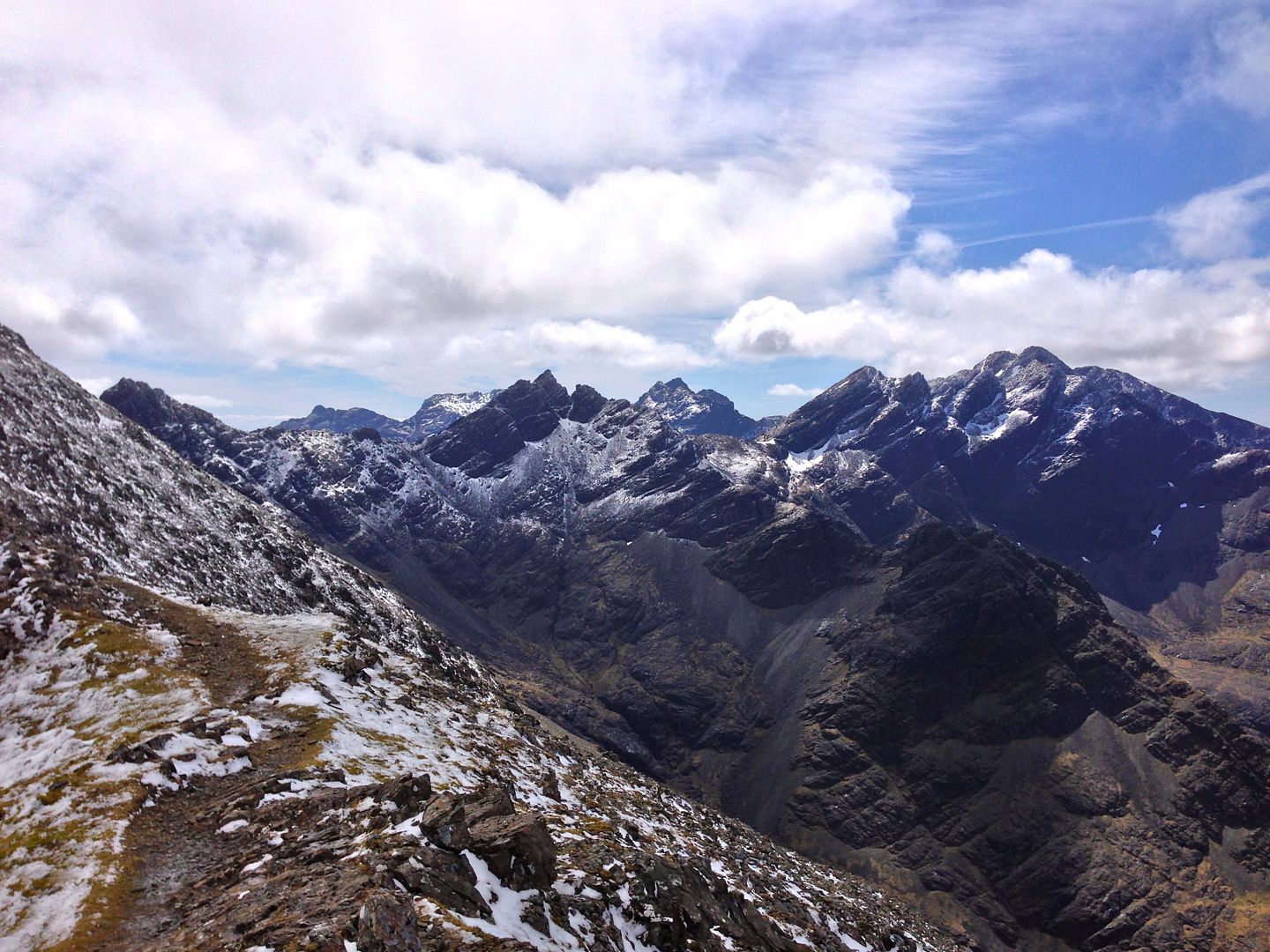 BELOW: Looking back across Skye. 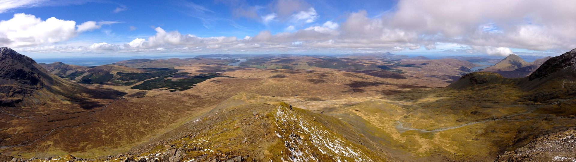 Topping out on the summit block, I was met with (yet again) a misty summit. Essentially the top 100' of the peak was enshrouded in mist, and nothing more. But to be honest, I was too joyful to really care. I had taken full advantage of the low elevation on this scramble and hauled it to the top. This was one of those rare moments where it was not exhausting to go fast, rather, with each step I felt further energized and eager to press on. Alpine ridge runs have always bee my favorite; doing one in the highlands on a day like this is hard to beat pretty much anywhere. BELOW: Departing pano of the entire massif. 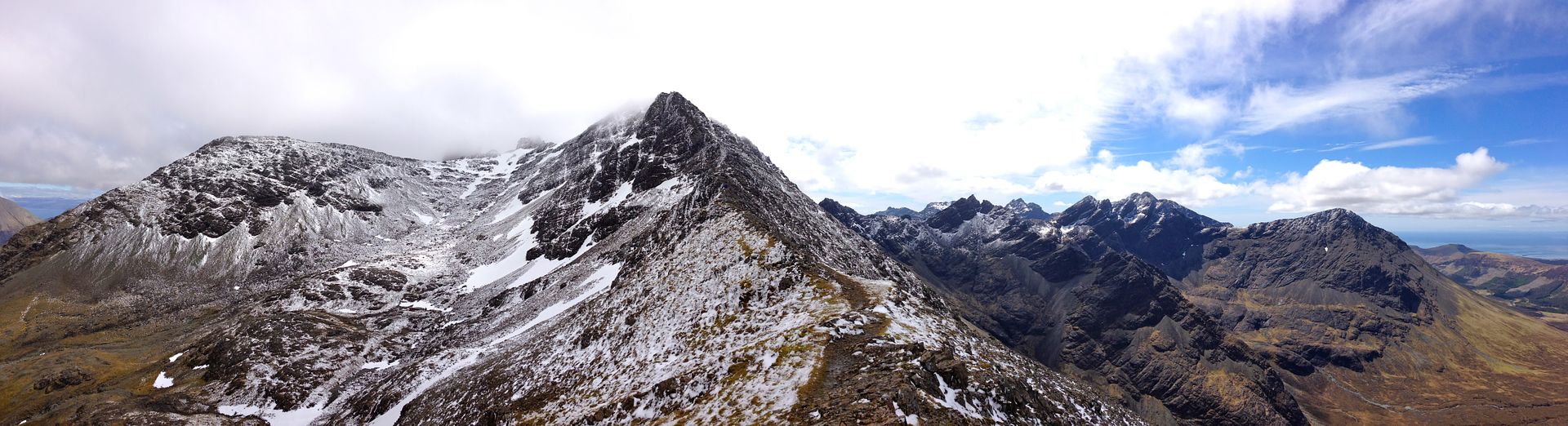 As I mentioned at the beginning, all this trekking replaced my intrigue with experience, my curiosity with love. This is an incredible country. There are many beautiful places and mountains in the world, but I think you would be hard pressed to find many spots with the heritage, the beauty, and the legacy that sweeps across the Highlands. Climbing here was a joy and an honor. I hope to be able to return some day and keep exploring. On this tiny little island, there is a lifetime's worth of it to do. Well, as usual, I have probably written far too much for a TR, but thanks for sticking with me if you did. Hopefully this has inspired at least one of us to head on over to Scotland to chase some Munros yourself. Happy Climbing! _ Thumbnails for uploaded photos (click to open slideshow):  Before getting out of Edinburgh, we started our first 'trek' up Arthur's Seat - a dormant 800 ft volcano/park loo")
 Duchray Castle - our home for a week. We were able to mountain bike the first 5 miles or so to the TH from here.")
 It may look nice, but make no mistake, there is a mud pit waiting under every blade of grass.")
 Sometimes the only way over the streams is to jump, as my partner Aaron demonstrates.")
 Leaving the trees, Ben Lomond finally appears in the distance.")
 Gaining the ridge and seeing the remainder of the route.")
 Looking back towards Loch Lomond far below.")
 Getting higher, a fuller picture of the loch comes into view.")
 Summit views.")
 Look familiar? The opening/childhood scenes from Braveheart were apparently shot in this valley.")
 Climbed by thousands each year, the trail work here is as perfect as one could ever ask for.")
")
 Some 2,000 feet up (half way), the views start to get a bit ridiculous.")
")
 Snowline came at about 3,000 feet. As the winds kicked up and temps dropped, this started to feel an awful lot like winter.")
 Thankful for not neglecting to bring all our warm gear, my partner Blair follows the cairns in the fog all the way to the top")
 Summit shot, with the remains of an old observatory behind. Today it has been converted to an emergency shelter.")
 A second of clear would afford a glimpse at the North Face cliffs. The drop and scale here is as impressive as anything we ha")
 Coming back under the cloud layer, other parties come into view on the ascent up.")
")
")
")
 Higher up - the route ascends the moor into the upper basin.")
 The North Ridge Route comes into profile.")
 Pressing on the lower sections of the ridge.")
")
 Looking back down.")
 The fun to come.")
 Getting higher and heading into the clouds.")
|
| Comments or Questions | ||||||||||||||||||||||||
|---|---|---|---|---|---|---|---|---|---|---|---|---|---|---|---|---|---|---|---|---|---|---|---|---|
|
Caution: The information contained in this report may not be accurate and should not be the only resource used in preparation for your climb. Failure to have the necessary experience, physical conditioning, supplies or equipment can result in injury or death. 14ers.com and the author(s) of this report provide no warranties, either express or implied, that the information provided is accurate or reliable. By using the information provided, you agree to indemnify and hold harmless 14ers.com and the report author(s) with respect to any claims and demands against them, including any attorney fees and expenses. Please read the 14ers.com Safety and Disclaimer pages for more information.