Download Agreement, Release, and Acknowledgement of Risk:
You (the person requesting this file download) fully understand mountain climbing ("Activity") involves risks and dangers of serious bodily injury, including permanent disability, paralysis, and death ("Risks") and you fully accept and assume all such risks and all responsibility for losses, costs, and damages you incur as a result of your participation in this Activity.
You acknowledge that information in the file you have chosen to download may not be accurate and may contain errors. You agree to assume all risks when using this information and agree to release and discharge 14ers.com, 14ers Inc. and the author(s) of such information (collectively, the "Released Parties").
You hereby discharge the Released Parties from all damages, actions, claims and liabilities of any nature, specifically including, but not limited to, damages, actions, claims and liabilities arising from or related to the negligence of the Released Parties. You further agree to indemnify, hold harmless and defend 14ers.com, 14ers Inc. and each of the other Released Parties from and against any loss, damage, liability and expense, including costs and attorney fees, incurred by 14ers.com, 14ers Inc. or any of the other Released Parties as a result of you using information provided on the 14ers.com or 14ers Inc. websites.
You have read this agreement, fully understand its terms and intend it to be a complete and unconditional release of all liability to the greatest extent allowed by law and agree that if any portion of this agreement is held to be invalid the balance, notwithstanding, shall continue in full force and effect.
By clicking "OK" you agree to these terms. If you DO NOT agree, click "Cancel"...
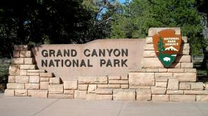
We road tripped out to California last week for a wedding on Jalama Beach, Santa Barbara. On the way back we took our time and explored our neighboring state to the Southwest, Arizona. We had originally planned to stay overnight in the Canyon at either the Bright Angel or Indian Garden Campground but we found that we were much to late to get the permits that would allow us to do so. It is recommended that you apply for your permits as early as possible, it sounds like at least three months out is recommended. Information about Backcountry Hiking/Permits can be found on the parks website Click here for more information The park down right discourages people from attempting to hike from the rim to the river and back in one day. But we decided to go for it anyways because of the cooler spring temperatures, physical ability, and the availability of water along the route. (I would not recommend hiking to the river and back in one day during the summer months, and for someone that is not physically fit. It is a longgggg hike in and even a longer hike out!) If you do decide to go for it, be sure to bring plenty of water and food, water filter (Pipes routinely break in the winter and water is not always available) and start early.
The buses begin running at 4:30 am from the Mather Campground, and will return every half an hour. Take the Blue Route bus to the Vistor Center, and transfer to the Orange Route Bus to the South Kaibab Trailhead. More transportation information here. We woke up at 4:00 am, make some breakfast burritos, and caught the Blue Route bus at 4:45 am. They dropped us off at the Visitor Center, and we waited for the Orange Route bus to come around. We arrived at the South Kaibab Trail at 5:30 am, and started down in the dark.
Topo map of the route
Google earth view
The cold wind that morning kept us going quickly down the trail, with only the west facing aspects of the trail blocking most of the wind. We arrived at the ooh ahh point while it was still dark, which was disappointing because some of the pictures I had seen at the visitor center made it look like it was worth seeing.
The sun started rising around the time we first had a glimpse of O'Neill Butte. O'Neill Butte was named after Buckey O'Neill who was a jack of all trades in Arizona in the late 1800's. While in Arizona he ran his own newspaper, practiced law, and served as a district court recorder, probate judge, superintendent of schools, and a tax assessor before the age of 30. Later he became the Mayor of Prescott and later the Sheriff of Yavapai County. Buckey promoted development of the Grand Canyon by convincing businessmen to finance a railroad to the South Rim, which eventually became the Grand Canyon Railway. Buckey's cabin still stands on the South Rim next to the Bright Angel Lodge. More information about Buckey O'Neill Link.
South Kaibab TH
O'Neill Butte
South Rim Sunrise
O'Neill Butte aplenglow
The long way down
Land of shadows
Mule train
Soon we encountered the first people of the day. First was a trail runner on a light jog to the river and then back up Bright Angel and two strings of burros packed with supplies with their wranglers.
The trail is remarkably well done and was in great shape for the amount of use that it gets, there were several rest areas along the way with bathrooms. On the South Kaibab trail there is no water sources until the Colorado River. It is on the North side just after crossing the Black Bridge by the Raft Beach. While filling our water we met a group of people who were on a 21-day raft trip down the canyon. If you're planning on a day hike of the canyon be sure to top off your water supply at this point.
Kaitlin and I sat by the Indian ruins and ate some food, and rested for a while before starting the return trip up the Bright Angel Trail. There were many people at the bottom of the canyon who had spent the night at the Bright Angel Campground and Phantom Ranch. We along the river to the Silver Bridge and crossed the Colorado River once again. The trail then heads north for a while along the river, before turning south then the up hill hike begins.
Colorado River
Black Bridge
Ancient Indian Ruins
Rafters on a 21 day float
Path leading to Bright Angel
Silver bridge
Kaitlin soaking her feet
Tricky buggers
Beginning of Indian Garden
Along the trail the foliage is surprisingly green because of the steam that runs along the trail for most of the way back up. When we arrived at Indian Garden rest point we rested for a while and ate some food. There was water, and restrooms at this point. Beware of the squirrels that lurk in this area, for they will steal any food that you set down or motion in their direction. As luck would have it we saw two of our friends who we were traveling with at Indian Garden and started back to the Trailhead together.
There are resting stops along the trail on the way back at 3 miles and 1.5 miles. Bright Angel was an enjoyable trail back to the rim because it is not as steep at South Kaibab, and has 300 feet less elevation gain due to erosion from Bright Angel Falls. Kaitlin and I arrived at the South Rim again around 2:00 pm, and waited at the bus stop for our friends to arrive to go back to the Campground for a much needed shower.
Whoops...
Almost out
The end!
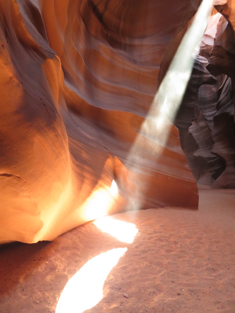
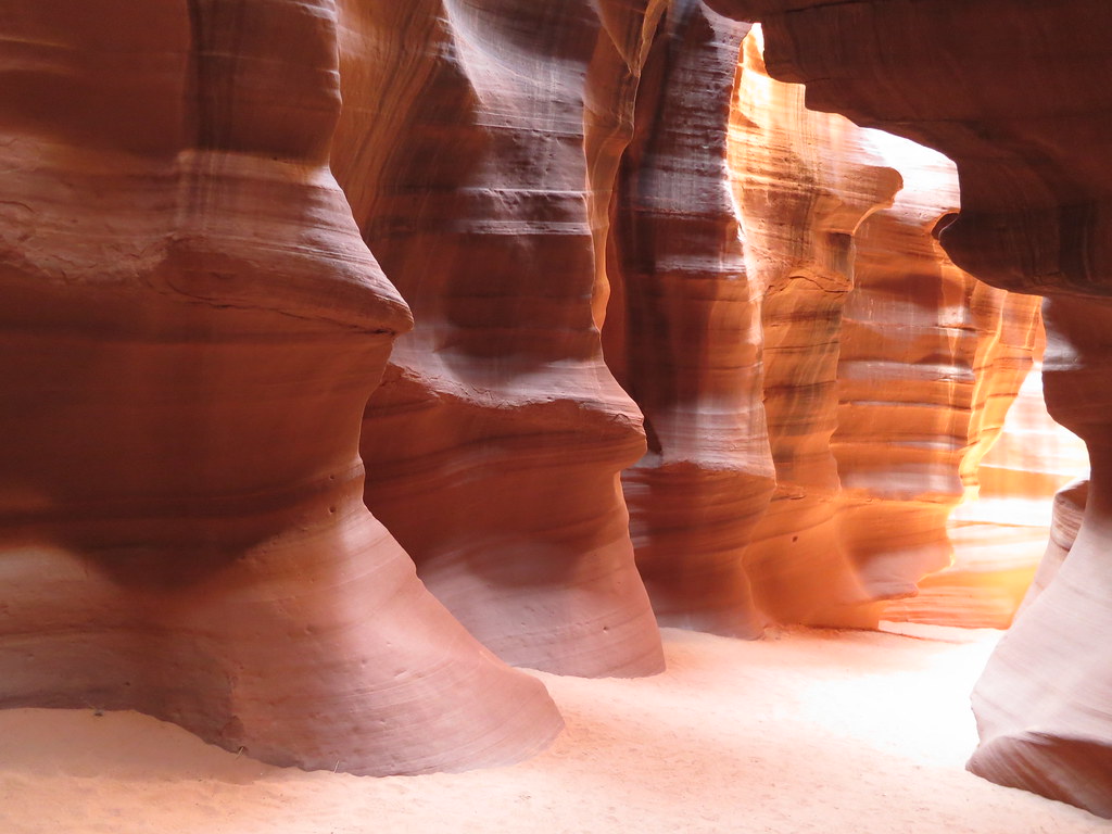
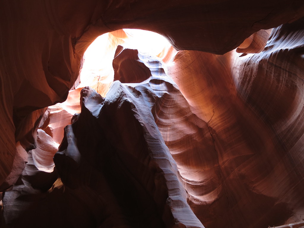
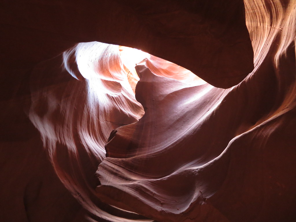
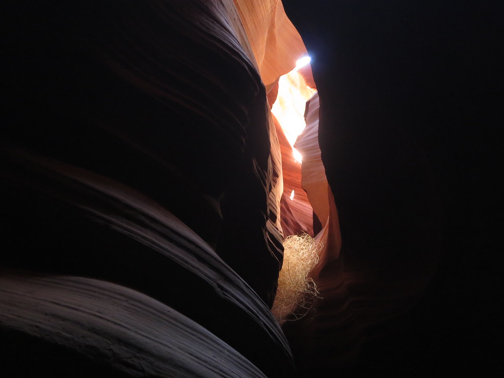
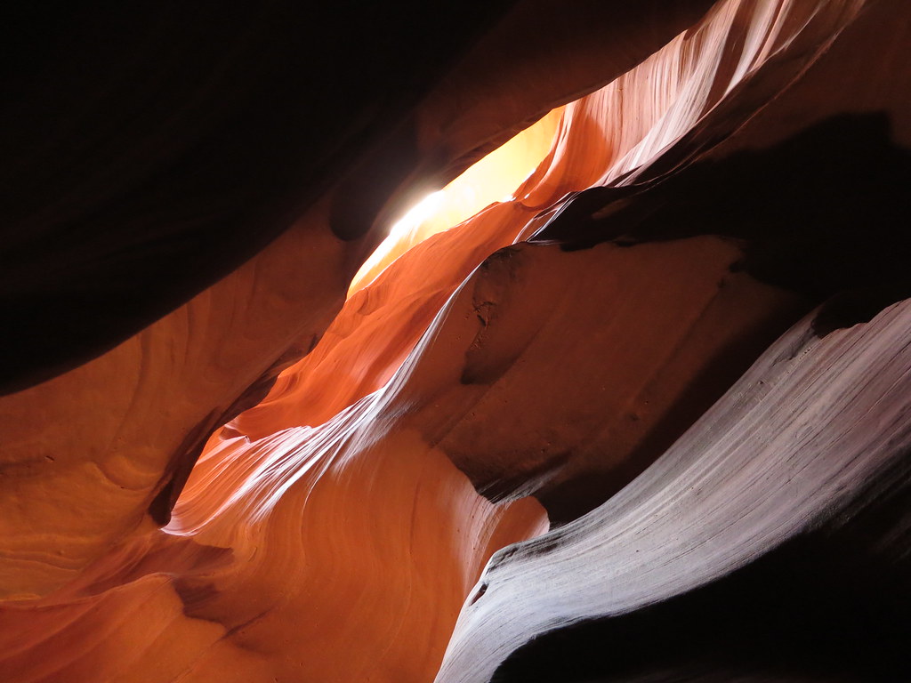
Antelope Canyon Page, AZ - Chasing Sunbeams
The next day we woke up at 5:00 am, packed up camp and drove to Page, AZ to see Antelope Canyon. Antelope Canyon is not a technical canyon, I included it because I thought some of you would enjoy the photos.
On February 20, 2013 there was a landslide that took out a large portion of US 89A about 25 miles from Page which is the most direct route. The department of transportation has a detour that follows US 160 then to SR 98 as an alternate to the closed highway. There is a dirt road that goes though the Navajo lands that they are planning on paving soon, that will become the main detour until US 89A is fixed. AZDOT Flyer
To access Antelope Canyon you must be guided because the canyon is on Navajo Land. We used the Adventurous Antelope Canyon Photo Tours, who did an excellent job. Our group consisted of only 5 people (Several of the other groups we saw consisted of 30+ people)
I did this same loop hike about 14 years ago, and you did it on my birthday! Thanks for the memories! An excellent report! You put a lot of effort and documentation into this. Yes, it is an extremely enjoyable hike! Mid-March is one of the best times to visit with everything in full bloom down there, various brush and cacti. I was also amazed to see so many redbud trees in bloom along Bright Angel and in the Havasupai area. Never thought of them as being SW flora as we have many of them here in IA. Beautiful Antelope shots! Thanks for the wonderful post!
We did the same route in late October...but spent the night at phantom ranch. This brought back some great memories. But the river is completely different. In late fall it is a beautiful green color as opposed the muddy brown in these photos. Didn't realize the spring runoff would have started already.
You've done an amazing job expressing what it is I love so much about Arizona...I really need to get back and do both of those trips one of these years!
I Man, Furthermore, Mongoose, Screeman57, gcoldewey, and ChrisinAZ - Thanks for your comments, glad you enjoyed the photos and report!
Mtnhub - Happy belated birthday! I am glad you enjoyed the report and that it brought back some memories.
bergsteigen - On your way to Pasadena also check out Sedona, AZ! Beautiful area with a ton of hiking. We did Trail #45 Sterling Pass to Vultee Arch, its an easy 5 miler.. but well worth the stop.
Fireonthemountain - Abe, aren't those holes just upside-down mountains? It was a good change of pace going the other way. I believe you'd enjoy running the canyon, bright angel has just enough of a slope to be challenging but still very enjoyable. Can't beat the views!
Caution: The information contained in this report may not be accurate and should not be the only resource used in preparation for your climb. Failure to have the necessary experience, physical conditioning, supplies or equipment can result in injury or death. 14ers.com and the author(s) of this report provide no warranties, either express or implied, that the information provided is accurate or reliable. By using the information provided, you agree to indemnify and hold harmless 14ers.com and the report author(s) with respect to any claims and demands against them, including any attorney fees and expenses. Please read the 14ers.com Safety and Disclaimer pages for more information.
Please respect private property: 14ers.com supports the rights of private landowners to determine how and by whom their land will be used. In Colorado, it is your responsibility to determine if land is private and to obtain the appropriate permission before entering the property.


 Topo map of the route")
 Google earth view")
 South Kaibab TH")
 O'Neill Butte")
 South Rim Sunrise")
 O'Neill Butte aplenglow")
 The long way down")
")
 Land of shadows")
 Mule train")
 Colorado River")
 Black Bridge")
 Ancient Indian Ruins")
 Rafters on a 21 day float")
 Path leading to Bright Angel")
 Silver bridge")
 Kaitlin soaking her feet")
 Tricky buggers")
 Beginning of Indian Garden")
 Whoops...")
 Almost out")
 The end!")
 Entrance to the Canyon")
 Sunrise over Monument Valley")
")
")
")
")
")
")


