Download Agreement, Release, and Acknowledgement of Risk:
You (the person requesting this file download) fully understand mountain climbing ("Activity") involves risks and dangers of serious bodily injury, including permanent disability, paralysis, and death ("Risks") and you fully accept and assume all such risks and all responsibility for losses, costs, and damages you incur as a result of your participation in this Activity.
You acknowledge that information in the file you have chosen to download may not be accurate and may contain errors. You agree to assume all risks when using this information and agree to release and discharge 14ers.com, 14ers Inc. and the author(s) of such information (collectively, the "Released Parties").
You hereby discharge the Released Parties from all damages, actions, claims and liabilities of any nature, specifically including, but not limited to, damages, actions, claims and liabilities arising from or related to the negligence of the Released Parties. You further agree to indemnify, hold harmless and defend 14ers.com, 14ers Inc. and each of the other Released Parties from and against any loss, damage, liability and expense, including costs and attorney fees, incurred by 14ers.com, 14ers Inc. or any of the other Released Parties as a result of you using information provided on the 14ers.com or 14ers Inc. websites.
You have read this agreement, fully understand its terms and intend it to be a complete and unconditional release of all liability to the greatest extent allowed by law and agree that if any portion of this agreement is held to be invalid the balance, notwithstanding, shall continue in full force and effect.
By clicking "OK" you agree to these terms. If you DO NOT agree, click "Cancel"...
Rusty and I and started are day early in Steamboat on October 20 2012. Heading North out of Steamboat on county road 129 to Seedhouse Road. We arrived to the Slavonia Trailhead (8,700') at 8:00 a.m, and we started our hike around 8:15 a.m. With unseasonably nice weather this year we thought that there wouldn't be much snow to deal with late in October.There are two different trails to access Mt. Zirkel we took the shorter route up Gold Creek Lake Trail. The other route is Gilpin Lake Trail but it adds another mile. Heading up Gold Cr lake Tr there is a log crossing about 1.5 up the trail. There is no bridge. Gold Creek Crossing
After the log crossing you start to gain a good amount of elevation through the woods there are about four switchbacks that will take you within 1/4 mile of Gold Creek lake. We took a minute at the lake and enjoyed the warm October weather. Gold Creek Lake
After the lake there is a small creek crossing thats is easy to navigate. There are usually a couple down trees to cross over the creek. The next 1.3 miles is along the creek that opens up into the Park Range with views of the Continental Divide and Ute Pass. Rusty and I with Ute Pass and the Divide behind us
The trail now connects back up with the Gilpin lake Tr and Red Dirt Pass Trail. We headed North on Red Dirt Pass Trail enjoying the views of the Continental Divide to are east and the Front Range to are West. We passed the Slavonia Mine to our West and kept going. You can see the Slavonia Mine better on your way back down trail. As we passed the Slavonia Mine the temperature started to drop and the wind started to howl. Continental DivideFront Range
The next 2.2 miles up to Red Dirt Pass was enjoyable but the winds increased and so did the snow on the trail. Red Dirt Pass We stopped and enjoyed some lunch behind some trees before hiking up Red Dirt Pass. The wind gusts were 40 mph and increasing while we ate. We continued up Red Dirt Pass with 40 to 50 mph gusts. Throwing us around like rag dolls.Rusty just above the Red Dirt Pass saddle
The final 1.2 miles to the summit of Mt. Zirkel were brutal the winds punished us the whole way. The snow increased to about 3 to 4 inches in spots and we started to get wet. We pushed on and enjoyed the awesome views of Wyoming and Colorado.Mt. ZirkelView of Gilpin Lake From the summit looking toward Flattop Mountain and Red Dirt PassRusty pushing hard to the summit
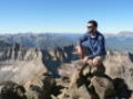
The final ascent was a good scramble on snow covered rocks. The wind was pushing us all over the place we reached the summit, (12,180') at 1:45 p.m. We hung out at the top for 10 minutes and enjoyed the view.The summit of Mt. Zirkel looking west toward Big AgnesBig Agnes The 50mph gusts were so strong we were lucky to keep our feet planted on the summit.
The hike back down was windy! The weather was great if you can endure the heavy wind. We had a spruce tree fall just to the side of us. We cruised down the trail the same way we came up. We got back to the car at 6 p.m. The 16 mile hike with 3,500 vertical feet is a endurance hike that is not easy.This hike is worth the views and lack of people. North Routt is a gem!!
Thumbnails for uploaded photos (click to open slideshow):
for the trip report. The wife and I did the Zirkel Circle on our recent anniversary. There was quite a bit of snow on the pass between Gilpin Lake and Gold Creek Lake. We had great weather and enjoyed being the only ones on the trail that day.
I've been to the Rawah Wilderness/Walden Sand Dunes a couple times now and I've looked longingly west towards Routt National Forest. Looks like a great place for some camping, hiking, and exploring. Thanks for posting on a different area of the state. Nice job!
Zirkel's back on my radar and I appreciate the info.
Caution: The information contained in this report may not be accurate and should not be the only resource used in preparation for your climb. Failure to have the necessary experience, physical conditioning, supplies or equipment can result in injury or death. 14ers.com and the author(s) of this report provide no warranties, either express or implied, that the information provided is accurate or reliable. By using the information provided, you agree to indemnify and hold harmless 14ers.com and the report author(s) with respect to any claims and demands against them, including any attorney fees and expenses. Please read the 14ers.com Safety and Disclaimer pages for more information.
Please respect private property: 14ers.com supports the rights of private landowners to determine how and by whom their land will be used. In Colorado, it is your responsibility to determine if land is private and to obtain the appropriate permission before entering the property.


 Gold Creek Crossing")
 Gold Creek Lake")
 Rusty and I with Ute Pass and the Divide behind us")
 Continental Divide")
 Front Range")
 Red Dirt Pass")
 Rusty just above the Red Dirt Pass saddle")
 Mt. Zirkel")
 View of Gilpin Lake")
 From the summit looking toward Flattop Mountain and Red Dirt Pass")
 Rusty pushing hard to the summit")
 The summit of Mt. Zirkel looking west toward Big Agnes")
")
 Big Agnes")