Download Agreement, Release, and Acknowledgement of Risk:
You (the person requesting this file download) fully understand mountain climbing ("Activity") involves risks and dangers of serious bodily injury, including permanent disability, paralysis, and death ("Risks") and you fully accept and assume all such risks and all responsibility for losses, costs, and damages you incur as a result of your participation in this Activity.
You acknowledge that information in the file you have chosen to download may not be accurate and may contain errors. You agree to assume all risks when using this information and agree to release and discharge 14ers.com, 14ers Inc. and the author(s) of such information (collectively, the "Released Parties").
You hereby discharge the Released Parties from all damages, actions, claims and liabilities of any nature, specifically including, but not limited to, damages, actions, claims and liabilities arising from or related to the negligence of the Released Parties. You further agree to indemnify, hold harmless and defend 14ers.com, 14ers Inc. and each of the other Released Parties from and against any loss, damage, liability and expense, including costs and attorney fees, incurred by 14ers.com, 14ers Inc. or any of the other Released Parties as a result of you using information provided on the 14ers.com or 14ers Inc. websites.
You have read this agreement, fully understand its terms and intend it to be a complete and unconditional release of all liability to the greatest extent allowed by law and agree that if any portion of this agreement is held to be invalid the balance, notwithstanding, shall continue in full force and effect.
By clicking "OK" you agree to these terms. If you DO NOT agree, click "Cancel"...
Snowmass & North Snowmass - Fall Gathering on 'S-Ridge'
Trip Length: 9.63 miles
Elevation Gain: 5,300 ft
Climbers: Luke (Chary), Kay (trailsntales), Natalie (nkan02), Michael (Michael J), myself
Everything about this trip was hastily planned. Once KeithK had put together the 14ers fall gathering in the nearby town of Marble, my interest was immediately piqued. As much fun as pounding beer in the woods and making a hungover assault on Elbert might normally be, these types of gatherings typically only interest me if the mountain and the route is compelling.
I hadn't yet climbed Snowmass, and I had always thought that tackling it from the west slopes or perhaps the lesser-known S-Ridge would be the most fun and least-difficult to plan for, logistically. As the gathering was starting to grow and take shape, so too it seemed, was interest in climbing the S-Ridge. A number of climbers decided to bail as it seemed like the S-Ridge was setting up to be a crowded route that day, and this is not a route to be taken lightly. There's real exposure, but more importantly, it's notoriously loose. More climbers equals more opportunities for rockfall. After all the dust had settled, it turned out that only 8 people or so had taken this route (2 groups of 3 and one group of 2).
After getting down to Marble on Friday afternoon and heading out to Lead King Basin, I learned a couple of important lessons: The road from Marble to the trailhead is only about 7 miles - but it takes much longer to travel than you think it will. Plan for 1.5 to 2 hours one way depending on driving skill and the vehicle you're taking. (Sharp corners make this much easier to navigate with shorter wheelbases). Another issue is that you'll burn much more gas getting back there than you'd initially think. There's a hefty elevation gain, followed by probably a 1,000 vertical-foot descent down to the trailhead. That long downhill approach to the trailhead came as a surprise. I was on fumes by the time I got to the trailhead, and only the generosity of strangers (thanks Norm!) got me out of the basin without having to make an embarrassing hike with an empty gas can. On the other hand, everyone we'd spoken to said that the road through the ghost town of Crystal is shorter, but much, much nastier ... not advised if you have any regard for your vehicle.
Alpenglow on the S-Ridge on the way in. The haze was from the fires in the Pacific Northwest burning at the time.
Our initial hope had been to pack all the way in to Geneva Lake, but the length of time spent on the Lost Trail Road meant that we'd be setting up tents in the dark. So, we pitched tents at the trailhead and settled in for what turned out to be a really cold night. In retrospect, I'm glad we'd stayed lower. I'd underestimated how cold it was going to get at the trailhead.
Luke, Kay and I set out just after 5AM - just behind another group of three from Colorado Springs who were headed for the West Slopes route. We could see as their headlamps faded into the distance that they were moving much faster than us.
First light on the Western Face of Snowmass from Little Gem Lake with Hagerman Peak to the right
I normally move pretty fast in the mountains: ~1,500 vertical feet per hour. So I figured we could make it from the trailhead (9,700 feet) to Little Gem Lake (11,800) in about 2 hours with another 30 minutes to get to the Class 2+ gullies. This would put us on the technical terrain just after first light at 7:30. We didn't get there until after 8:30. We were moving slooooowww ...
Luke and Kay approaching the 2nd gully (on climber's left)
The 3rd / 4th Class rock between the two gullies
Approaching the gullies is where the true character of the mountain begins to show itself. There's a steep Class 2+ option in the gully itself, which looks loose, miserable, and downright treacherous if there's any lingering moisture. The most solid rock and climbing is to the right of the gully itself and contains Class 3 and some low Class 4 moves.
This is the first example on the route where I'd say, "The best way to approach this ridge is to treat it as a Class 4 route." There are typically easier technical alternatives, but the best way to resolve route-finding issues on this ridge is to always pursue the most stable rock. It may require more technical moves and more exposure, but seems to be the safest alternative on a mountain where everything shifts and nothing can be trusted with your full weight until it's been tested.
Daylight breaking on upper Lead King Basin and Little Gem Lake
Solid Class 3 rock with only a couple of Class 4 moves
After some Class 3+ climbing on mostly solid rock, the pitch then begins to relent. Follow a consistent line upwards until you run out of mountain ... then turn left. Welcome to the S-Ridge.
Looking back on Geneva Lake after gaining the ridge
From the bottom of the gully to the ridge took another full hour. My internal schedule was rapidly going out the window. Fortunately, weather did not look to be a factor at all that day.
More Class 3 climbing below the ridge to get to the next landmark, a distinctive fin-shaped rock at the top of the ridge
Kay coming up from below
Luke leading this section on solid Class 3 rock
Looking back at this notch from the previous picture
Class 3 line to the left, Class 4 line to the right
After going through the notch, the best rock is to the right. A solid series of Class 3 moves will get you to the ridge crest. Some sportier Class 3 / 4 slabs can be climbed just to the right as well. All roads lead to the same place.
The Class 3 line up to the ridge
Luke opts for the Class 4 slabs
After passing the 'fin', the ridge provides a flat section for a brief respite. It's the calm before the storm as the crux of the route lays just beyond.
Luke waiting for the stragglers
Kay starting across the flat ridge with Treasury Mountain in the distance, to the right
The last easy section before the crux
Looking up at the Class 4 slabs
Luke and I made a conscious decision to tackle the harder route, the gully on the other side of the notch looked like no fun, whatsoever. This was another section of the mountain where the rock was more stable, but the route was harder and much more exposed.
The slabs start with some fun scrambling, but then the hand-holds begin to peter out after you've gotten high enough where losing it and sliding backwards is no longer an option. A traverse to the right got us back to a section with more handholds where we could keep moving upwards.
The crux of the route is the short, ascending traverse back to the ridge with some major exposure underneath. The rock here, however, is perfectly solid. It's just a no-fall zone for about 30 feet.
Luke making a macho move to traverse around the corner of that block. Kay and I chose to go straight up rather than having to belly-roll around that rock.
Kay moving up before the corner of the exposed block to gain a trench that provided some protection from the exposure.
In the trench and safely past the most exposed section
Working around the last difficulties to regain the ridge
Once back at the ridge, climbers can then traverse over and ascend the loose Class 3 gully, or stay on the ridge proper, then traverse left at the top of the gully. This is yet another place where the rock is better on the ridge. That gully just looked steep, loose, and nasty - like the kind of place where a slide could quickly get out of hand.
There are two intuitive places to make the traverse north out of the gully. We chose the higher line, but the other highlighted option "goes" as well.
Luke leading up to the highlighted crossover point
Luke working back to the ridge and more stable rock. The yellow line is how Kay and I chose to tackle this section
Kay ascending the ridge while looking back at the crux section
After negotiating the crux I knew I had no intention whatsoever of trying to downclimb the S-Ridge. Up was more than enough for me. While I was not looking forward to a West Slopes descent, especially not really knowing or researching it, it seemed the only viable option.
It was here where Scott Farish, Flintster as well as Natalie and Michael's group caught up with us on the ridge ... after we'd had a two-hour head start. This is not only a testament to their speed on the mountain, but shows how slowly we were moving as well. They chose to climb up the gully and skip the Class 4 crux section. Neither option is a cakewalk.
Scott Farish and Flintster's group coming up the Class 3 gully.
Kay negotiating some of the last hard moves with Geneva and Little Gem lakes behind
Once past the crux and north of the gully, the slope relents and the summit is quickly attained. The first thing that stands out about this summit is how small it is. There's room for only maybe 2 or 3 people on the summit, plus a short scramble to get on top of the "true" summit rock.
We topped out at 12:30 - 7.5 hours from the trailhead. This was already 2.5 hours behind the schedule I wanted to keep that day ... but the views made it all worth it.
Looking over on the traverse to Hagerman Peak with the Bells and Pyramid in the background.
During the climb, Luke and I had spied a gully right at the saddle on the Hagerman traverse that looked like a potential 'bail-out' route. I don't know if it's ever been attempted, but it visually looked like one possible way of getting off the mountain. If you can get down that short gully to the talus below Hagerman, it would be an easy hike out to Lake Geneva in a pickle.
Since the weather was still bomber, we didn't give it any serious consideration. However, if one climbs the S-Ridge, you'll get an excellent view of the gully-in-question on the way up.
Capitol from the summit of Snowmass
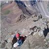
Me on top
Luke on the summit block
Natalie, Michael, scottfarish, flintster and one or two others quickly caught up to us on the summit. I wanted to head over to North Snowmass since the traverse over to the West Slopes route headed north anyhow. Since we were already way late by my internal clock, we didn't linger on the summit very long.
Natalie, Luke and I decided to make a quick trip over to North Snowmass before descending the normal West Slopes route.
The route from Snowmass to North Snowmass. A climber can be seen on Snowmass' summit
The only sketchy part of the traverse to North Snowmass is a Class 3 section just above the snow. The moves weren't terribly difficult, but the exposure was not trivial. Upon return, we chose a Class 4 line that mitigated the exposure.
Once we reached the summit of North Snowmass, we looked back and were surprised to see Michael heading over as well behind us. However, when we spotted him he was right where the 'red X' is in the photo, and staring down at roughly a 200 foot drop. Fortunately, we were able to yell out to him to turn around and pass below this gendarme.
A closer look at the exposed traverse point above the snow. The red line represents a Class 4 alternative used during the return which avoids the exposure.
Natalie working her way up the Class 4 bypass route with North Snowmass and Pierre Lakes behind her
The ridge to Capitol from North Snowmass. I've now seen this ridge from both terminal points ... and it looks horrific from both sides.
Michael on the miniscule summit of North Snowmass. It's about 600 feet of air 1 step behind him.
It was now 2PM and we were still at 14,000 feet. This was far too late for my comfort. It was clearly time to suck it up, head down the West Slopes, and get off the mountain.
First look down the West Slopes
The West Slopes are just a loose Class 2 / Class 3 downclimb where you try to find the path of least resistance and move cautiously to avoid sending down any rocks. While the gully itself is often an intuitive place to be, this is also where rocks will be tumbling down as well. So, for the most part, we chose to stay to the right of the gully (on descent) and minimize rockfall risk.
Michael and Kay working down some Class 3 sections
Just as the safety of the talus field is tantalizingly close at the bottom of the slopes, the mountain throws one last challenge at you. The gully gets steeper and begins to cliff out. While descending you have to work your way to the right and head towards the waterfall.
Some cairns will encourage you to keep going past the waterfall, but this leads to some really sketchy places. Unfortunately, this is where Luke went. While over there, a solo climber above us started a rock slide that headed straight at Luke. Natalie and I were able to bark verbal commands at Luke that allowed him to hide until the danger had passed.
Luke getting into some hairy terrain to the right of the waterfall
Kay started following Luke in the same direction and ended up taking short fall. Natalie and I worked our way down a slippery line at the edge of the waterfall itself. It wasn't ideal, but we got down in one piece.
The best line around the waterfall unfortunately can't be seen from above. Only from below does the best route present itself. So, if you'd climbed the West Slopes, you'd see it on the way up. If you've climbed the S-Ridge, you probably would want to have this photo memorized ahead of time. Once below the waterfall, we were able to guide the other climbers down the right route:
Kay, Michael (and the solo climber) working around the waterfall. The mossy edge of the waterfall can be seen at left.
It was now 4:15pm, and I'd been on the mountain 3 hours longer than I had planned on. While I wasn't happy about our pace, this is also a place where you have to stay with your partners until everyone's down and safe (as was reinforced a week later with slimshady's accident). Once everyone was back on the talus below the waterfall, it was Class 1 and 2 all the way back to the trailhead.
I felt we could call this a successful climb from here and split up. I had to get OUT of Lead King Basin since I knew my wife would start worrying about me (I'm rarely ever late getting off the mountain) and cell phone coverage is essentially non-existent until you make it all the way back to Carbondale. Natalie, Luke and I turned on the afterburners and flew back down to the trailhead.
One last look at the route over the entire western flanks of Snowmass
Luke reflecting on his accomplishments for the day
Natalie leading the way back to Geneva Lake
Geneva Lake with Crystal Peak behind
One last look back at the S-Ridge and the day's adventures
Looking up towards Fravert Basin, the Bells and Sleeping Sexton
At the trailhead, I was able to 'borrow' 2.5 gallons from a camper named Norm who wouldn't even accept payment for the gas. It was already about 6:30PM, and I knew that I was at least 2 to 2.5 hours away from 'civilization' where my cell phone would work again. We dropped Natalie off at the fall gathering campsite in Marble, spent about 10 minutes saying hello to people, then Luke and I got down the road to Carbondale.
It was 9PM by the time I was back in coverage, and my cell phone lit up like a Christmas tree. My wife, who's normally accustomed to hearing from me in the late afternoon, began to fear the worst and had called Pitkin County SAR. The SAR volunteer was able to give her some information that helped alleviate some worries: namely, Lead King Basin is a really remote area where cell phones don't work, the S-Ridge is deceptively long, and it can take 1.5 to 2 hours just to drive the 7 miles from the trailhead to Marble. Once I was able to actually talk to her, she realized that we all had gotten up and down safely, but that a combination of remoteness and slow climbing had placed me uncharacteristically behind schedule.
Lead King Basin is one of the most stunning locations I've ever seen in Colorado, and the S-Ridge completely lived up to the hype. However, it is really remote. If you get in trouble back there, you're pretty much on your own. The most important lesson learned for me on this trip was to not to overestimate the speed of your climbing partners, and to better understand the remoteness of the route so that you can set a realistic itinerary. Spouses don't need to experience undue stress, that way.
My GPS Tracks on Google Maps (made from a .GPX file upload):
Excellent route marking and detail in description. Good lessons learned as well on judging route times based on difficulty. Was surprised by the lack or snow/ice until I saw the climb date. Wonder how the conditions are now.
Congrats to you all on completing a great route. The descent down the West Slopes was worse than Columbia in my opinion, NEVER AGAIN!!!
I have to agree wholeheartedly with Natalie about the weak team member statement. I have ZERO problem helping out or waiting for team members IF they were upfront and truthful concerning their skills or pace. Misrepresenting yourself is dangerous to you and your team, bottom line.
Dave, it might be faster to bike that road in some sections. But one other surprise for me was that it goes up around 3,000 vertical feet from the town of Marble, and then drops back another 1,000 to the trailhead. That would be a serious hump on bike.
Wow. I did this mountain in exact reverse on July 21st. Up the West Slopes and down the S-Ridge. I was curious to see how you opted around the crux on the S-Ridge. I took the same route, only going down. That got my heart pumping, especially with that one airy move. After I did that, I wondered if I had made a mistake and should have gone down and around the other way. Either way, I was glad to have made it...but don't think I will seek it out again! That being said, the S-Ridge was a lot of fun compared to the slog up the West Slopes. Bottomline, there is no 'easy' way up this underated in difficulty mountain.
Well done.
(Ironically, I too got down to the Trailhead and just as I parked, by gas light went on. That stressed me out for my two days of climbing, wondering if I'd have enough fuel to get back to Marble. Fortunately, I had enough to make it to Carbondale. The light simply went on because I was at 1/3 tank going downhill to the trailhead. Still, there is NOTHING as stressful as wondering if you are going to have to hike out to find gas.
I did this same route at the end of August. One of the most underrated 14ers, IMHO. I thought the S Ridge was stable and fun, and underestimated how much time it took to climb it, too.
The West Slopes felt like a death trap to me. Very relieved when I was off the mountain.
It is one of the most beautiful areas I've seen in CO, echo that.
The S Ridge offers stunning views, quite the perch.
Great report - your reports are da bomb!
Congrats on safely completing the climb!
Cheers!
Looking at your route lines, I think we followed you and Luke step-for-step. I still don't regret our decision to come back down the S-ridge... it was just one of those gut feelings I had to go with. Nice meeting you guys at the summit... sorry that we didn't get to share beers back at camp. Oh, and you are spot-on about underestimating that mountain. We saw your headlamps ahead of us that morning, and we went back to the headlamps that night - 14 hours total! YEEHAW!
This makes me sad that I couldn't make it. Looks like an awesome area. I love how detailed your trip reports are...I'll definitely be referring to it if I ever attempt this route.
Classy, too. The S-Ridge is one of the finest routes on a CO 14er, though it can take longer than you expect.
Much classier than the comment seen above about one of your partners. Really surprising...
Nice pictures and a good report. The rock rib to access the ridge is definately the way to go, those gullies are quite loose. I found the ridge itself to be good solid rock that genrally only becomes loose the further you drift from the crest. I too had a long day though with only the summit offering me cell phone reception to call home.
TR...congrats to all of you on what looks to have been an intense and challenging day! And thank you for an informative and very helpful account of the route; I will be religiously reading your trip report again next summer before shooting for the S ridge! Looks a lot like the N Buttress route up El Diente...
I wish I would have had this trip report to follow when I went up.
I appreciate the color-coded lines depicting your route, especially in the crux.
I agree with the report and the 10 comments that follow, so I'll discuss another topic:
In my opinion the road from Marble to Crystal is not half as bad as the sea of switchbacks down into Lead King Basin. I climbed this route on Labor Day weekend and I made the mistake of driving from Gunnison over Schofield Pass instead of driving around. Actually, it wasn't a mistake, but I had no idea what I was getting into. The road from Crystal to the trailhead was the calmest part of that trip.
Nice job, Phil. Let's get out and climb something again. It's been way too long. 1.5 to 2 hours to drive that 7 miles? Holy crap. Surely, it'd be quicker by bike to do that.
Phil, I was glad to finally have an opportunity to climb with you! One good thing, we did S ridge in perfect conditions without any snow on it - I just cannot imagine it with snow, it would add so much more sketchiness to the already difficult ascent line.
And I did not realize until now that MichaelJ and I skipped the crux - we were just following Scott Farish and his group and yelled at them what's the best route to go and they were already in the gully, so we followed, caught up and passed them there (they had about an hour head start on us). I was pretty happy with our ascent time of ~6 hours from the TH to the summit, but unlike you we did not have to take care of the weak partners (sorry, Kay - I was really surprised to see you up there).
Descent of West slopes took forever, I agree (and for the same reasons), but it is not a bad route to descend and can be done reasonably fast with a solid group with some experience with loose rock. As several recent episodes have showed, Snowmass is not the type of mountain to joke around.
Caution: The information contained in this report may not be accurate and should not be the only resource used in preparation for your climb. Failure to have the necessary experience, physical conditioning, supplies or equipment can result in injury or death. 14ers.com and the author(s) of this report provide no warranties, either express or implied, that the information provided is accurate or reliable. By using the information provided, you agree to indemnify and hold harmless 14ers.com and the report author(s) with respect to any claims and demands against them, including any attorney fees and expenses. Please read the 14ers.com Safety and Disclaimer pages for more information.
Please respect private property: 14ers.com supports the rights of private landowners to determine how and by whom their land will be used. In Colorado, it is your responsibility to determine if land is private and to obtain the appropriate permission before entering the property.


")
")
")
")
")
")
")
")
")
")
")
")
")
")
")
")
")
")
")
")
")
")
")
")
")
")
")
")
")
")
")
")
")
")
")
")
")
")
")
")
")
")
")
")
")
")