Download Agreement, Release, and Acknowledgement of Risk:
You (the person requesting this file download) fully understand mountain climbing ("Activity") involves risks and dangers of serious bodily injury, including permanent disability, paralysis, and death ("Risks") and you fully accept and assume all such risks and all responsibility for losses, costs, and damages you incur as a result of your participation in this Activity.
You acknowledge that information in the file you have chosen to download may not be accurate and may contain errors. You agree to assume all risks when using this information and agree to release and discharge 14ers.com, 14ers Inc. and the author(s) of such information (collectively, the "Released Parties").
You hereby discharge the Released Parties from all damages, actions, claims and liabilities of any nature, specifically including, but not limited to, damages, actions, claims and liabilities arising from or related to the negligence of the Released Parties. You further agree to indemnify, hold harmless and defend 14ers.com, 14ers Inc. and each of the other Released Parties from and against any loss, damage, liability and expense, including costs and attorney fees, incurred by 14ers.com, 14ers Inc. or any of the other Released Parties as a result of you using information provided on the 14ers.com or 14ers Inc. websites.
You have read this agreement, fully understand its terms and intend it to be a complete and unconditional release of all liability to the greatest extent allowed by law and agree that if any portion of this agreement is held to be invalid the balance, notwithstanding, shall continue in full force and effect.
By clicking "OK" you agree to these terms. If you DO NOT agree, click "Cancel"...
*Disclaimer* I have Huron tagged but did not summit. I do find this will be useful for Huron Peak hikers though.
Mount Belford, Mount Oxford, Missouri Mountain, Huron Peak*
Start Time: 2:02 AM Belford Summit: 4:35 AM Left Belford Summit: 4:41 AM Oxford Summit: 5:18 AM (37 minutes from Belford) Left Oxford Summit 5:40 AM Belford Re-Summit 6:12 AM (32 minutes from Oxford) Missouri Summit 7:45 AM Back to Missouri Gulch TH: 10:10 AM Left from Huron 2WD TH: 11:00 AM Arrived at Huron 4WD TH: 11:22 AM Found out I was on wrong trail: 11:45 AM Started up Huron Trail: 12:00 PM Lost track of time, failed to ascend Huron back on highway by 2:30 Total Time: ~12 hours Distance: 25 Miles Elevation Gain: ~9300'
9/7/2012
Left Golden at 2:30pm, arrived at the trailhead around 5, prepared pack, ate a boat load of pizza and went to bed at 6pm.
I slept soundly in my car until sometime after dark 2 dudes pull up right beside me and start to prepare their camping stuff. No big deal, I'll just put a hat over my eyes. Then they crank their music, no big deal I'll put in ear plugs. They leave, but must have forgotten something because they came back around 30 minutes later and started cranking their tunes again. Argh!
9/8/2012
Woke up @ 1:30, on the trail by 2. Saw a black bear and unzipped my coat to use as wings and said many mean things to the bear. The bear couldn't handle my verbal thrashing of his character so it ran off. It was a pretty wimpy bear actually. It was dark and I couldn't grab a picture but it looked something like this:
Wimpy bear
Not going to lie though, this freaked me out until I got above tree line.
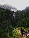
Got to Belford pretty slowly, then I got some energy and ran to Oxford and back a bit quicker. Then the sun came out and I could see Missouri.
Oxford as seen from Belford Missouri Mountain
Many people suggest going to the South of the traverse then regaining the ridge. NO NO NO! there is probably a way to do this, but I dropped down to about 500' above the lake once the climbing got bad and it was a loose steep scree field back up to Missouri. If this is fun for you give it a shot otherwise just descend to Elkhand pass on the NORTH of the Missouri saddle.
The route I took; NOT recommended!
I finally got to the Missouri summit by 7:45 AM, and stretched, got some food and descended.
The easy part - Belford Oxford Missouri Missouri Looking North and West Missouri Looking South and West
My plan was to descend the West side down to Clohesy lake then ascend the East side of Huron, but I could not for the life of me find the descent route off the West side. I thought that it gained the ridge at the same point as the Missouri Gulch trail, which it does according to the route description, but I could not see any sign of a trail, I spent another 20 minutes half regaining the summit of Missouri looking for this but could not see any trail anywhere on the West side.
Looking at the route description I don't think there really is one. If you want to do the Missouri West ridge I highly recommend a GPS with Bill's .gpx file. (this may be easier if you had ascended this way)
My next idea was to go back to my car and then drive as far as I could to the Huron TH and then thumb a ride to Huron.
Fall Colors on Missouri Gulch descent
I got down to my car quickly and downed some more pizza, refilled my camelback, iced my knees and pondered if I wanted to just call it a day. After a bit of a break I decided to head for the Huron TH. I parked at the 2WD trailhead and ran up the 4WD road.
I was running so fast that I did not notice the Huron trail was not the main trail at this trailhead. I started becoming concerned that I was on the incorrect trail because I saw no one on it (I figured a 14er trail on a weekend would be pretty busy) I ran back to a group who I passed, and they reassured me that it was the Huron trail and I should keep going. A few miles up the Apostle Basin trail and I was certain I was lost.
If you see this you've gone way too far
By the time I had ran back to the Huron TH I was incredibly sore from running all day (I had done almost a marathon's worth of running up to then). I started up the Huron TH, popped an ibuprofen and a gel packet, but the soreness did not subside. After getting to treeline I decided to turn around and limped back down to my car.
2 guys gave my a ride the last mile or so which I was really appreciative of because my limp got progressively worse.
I wanted to do these 4 in one day to test my limits. They were certainly tested and I know my limits now. I couldn't blame my lack of success on anyone but myself this time, my knees are simply not that strong. The only disappointing thing is that if I had taken the actual Huron trail I would have made it to the top of Huron instead of almost gotten to the 3 apostles.
I wanted Huron so badly. Honestly I was very tearful when I had to turn back and was incredibly upset with myself. I started blaming other factors in my life for my failure but finally accepted that the problem was with me. This was a very humbling experience for me, but healthy for me to finally experience. I truly gave it my best shot though, and can return next summer to redeem myself with a LaPlata to Huron marathon. I will be training hard in the mean time as I really do not want this to happen to me again.
Thumbnails for uploaded photos (click to open slideshow):
I'm pretty sure I probably saw you at some point today. My partner and I were hiking up the Missouri Mtn standard trail. I'm wondering if you were the one who was asking us about the trail down - you seemed to be moving fast.
First off, I thought you were crazy for trying all 4, but good job on the 3. I didn't get your text about missing the Missouri trail until I was on the ridge 500 ft below Huron summit. I assumed we would either see you coming up the trail as we were descending (Emily and I began descending at 12:05) or you would have called it a day. I'm sorry you got mixed up.
lackerstef: Thanks. I was considering those after failing to find the West Missouri trial.
emohr: Thanks man. I couldn't have taken a pick of the bear anyway it ran away moved so fast.
Doctor No: Nice to meet you too! Thanks again for the ride.
aliciaf: Yes, saw you between the missouri summit and the Elkhead pass trail branch.
HarknessHooligans: Thanks! Google had a limited selection of animated bears.
rambis_21: Sorry Craig. I saw your vehicle and it encouraged me to keep running to catch up with you guys. I might have if I hadn't taken the wrong trail for several miles. Glad you and Emily had a successful trip. Congrats to her on her first 14er!
Impressive indeed, especially your time on the Oxford to Belford slog! Word of advise though from an older man: take care of those knees so they'll be around for a lot longer!
Sounds like you had an epic day. Didn't I tell you to drop way down on the Missouri-Elkhand Pass traverse? I too fell for the same thing even after reading many trip reports that said to drop way down. However I did the peaks in the reverse order. Huron standard route and La Plata Southwest Ridge route from Winfield will make for another Epic Day. Don't forget that you have to walk about 2 miles from Winfield to each trailhead. Good Job
You still had a good last hoorah before the snow flies, as you put it. Since no one has mentioned it, the standard Huron trail is a left turn right at the gate. I almost missed it in the dark last year until other hikers pointed it out.
Don't be upset. I'd suggest scouting each mountain separately, and then link them together. My gps batteries died on West ridge of Missouri, otherwise I'd share a track. I didn't see a good trail up Huron from Clohesy lake though.
Caution: The information contained in this report may not be accurate and should not be the only resource used in preparation for your climb. Failure to have the necessary experience, physical conditioning, supplies or equipment can result in injury or death. 14ers.com and the author(s) of this report provide no warranties, either express or implied, that the information provided is accurate or reliable. By using the information provided, you agree to indemnify and hold harmless 14ers.com and the report author(s) with respect to any claims and demands against them, including any attorney fees and expenses. Please read the 14ers.com Safety and Disclaimer pages for more information.
Please respect private property: 14ers.com supports the rights of private landowners to determine how and by whom their land will be used. In Colorado, it is your responsibility to determine if land is private and to obtain the appropriate permission before entering the property.


 Wimpy bear")
 Missouri Mountain")
 Oxford as seen from Belford")
 The route I took; NOT recommended!")
 If you see this you've gone way too far")
 Fall Colors on Missouri Gulch descent")
 Missouri Looking North and West")
 Missouri Looking South and West")
 The easy part - Belford Oxford Missouri")