Download Agreement, Release, and Acknowledgement of Risk:
You (the person requesting this file download) fully understand mountain climbing ("Activity") involves risks and dangers of serious bodily injury, including permanent disability, paralysis, and death ("Risks") and you fully accept and assume all such risks and all responsibility for losses, costs, and damages you incur as a result of your participation in this Activity.
You acknowledge that information in the file you have chosen to download may not be accurate and may contain errors. You agree to assume all risks when using this information and agree to release and discharge 14ers.com, 14ers Inc. and the author(s) of such information (collectively, the "Released Parties").
You hereby discharge the Released Parties from all damages, actions, claims and liabilities of any nature, specifically including, but not limited to, damages, actions, claims and liabilities arising from or related to the negligence of the Released Parties. You further agree to indemnify, hold harmless and defend 14ers.com, 14ers Inc. and each of the other Released Parties from and against any loss, damage, liability and expense, including costs and attorney fees, incurred by 14ers.com, 14ers Inc. or any of the other Released Parties as a result of you using information provided on the 14ers.com or 14ers Inc. websites.
You have read this agreement, fully understand its terms and intend it to be a complete and unconditional release of all liability to the greatest extent allowed by law and agree that if any portion of this agreement is held to be invalid the balance, notwithstanding, shall continue in full force and effect.
By clicking "OK" you agree to these terms. If you DO NOT agree, click "Cancel"...
The route less traveled - a tribute to fallen climbers
Route: Columbia's East Ridge from Three Elk Creek TH
Climbers: scottfarish, flintster
Total miles: ~11 miles
RT time: 8.5 hours
... It's been a tough week here for the 14ers.com community. As we said goodbye to one friend and brother who lost his life on Hagerman Peak, we were soon dealt another blow by losing a fellow climber on Crestone Peak. I cannot claim to have ever met Rob Jansen or Chris Gray... I most likely saw their pictures on other trip reports or came across their names mentioned in forum posts. But their deaths, followed by the outpouring of tributes and support from this 14ers community, have suddenly made me feel like I knew them in spirit all along. The week has caused me to reflect a lot on life, and the reasons why I get up early in the morning to trudge up thousands of vertical feet only to (hopefully) claim a victory that will probably only be important to me. It may sound cliche, but Rob and Chris both left this world while engaging in their passion. When they left their respective houses that morning, neither man assumed that the worst would happen. We all enter these high-altitude portals knowing the risks, but we accept the risk because the feelings and experiences we enjoy in the high-country squash any feelings of self-doubt or remorse for never even trying. This trip report is dedicated not only to Rob and Chris, but to all the fallen climbers who have left this world while doing what feeds their souls.
On to the report...
Flintster and I originally had other plans to hike Bierstadt with some friends on Friday, but plans fell through for just about everyone except the two of us. I suggested that we hit Columbia instead, and that we take a lesser-traveled route up the east ridge. I had done this same route 7 years ago, and I figured that the trail would probably still be discernible. I have not done the standard route on Columbia, but the route description and stories of its nasty loose west slopes were enough to convince us to seek an alternate route. The parking lot is easy to find using Roach's guide for directions, and it's a surprisingly short distance from the center of Buena Vista. The only drawback to this is that you start hiking at 9,260 feet. The road is a little rough, but any 4WD vehicle should have no problem getting to the trail head. The TH is marked by a beat-up sign for the "Three Elk Creek Trail Head". You start hiking a logging road for about 200 yards before you come to the following junction - at this point, veer left onto the trail:
left onto the trail
This trail is very well-defined, even as you cross the Colorado Trail after ~1.5 miles
Continue across the Colorado Trail
The trail begins to fade a little after the CT, and it crosses 3 Elk Creek several times. By the time you get to tree line, route finding will be at your best guess. The trail fades completely right about here...
a clear view of the 3 Elk Creek basin and Columbia in the distance
With the trail faded, and no clear route to the summit, Flintster and I made a hard right turn and ascended the mild slopes to the east ridge. The best route was to hug the line of dead trees and until the gain the ridge. This is the view you see of the basin as you gain the ridge:
Once we gained the ridge, it was a gradual ascent to the summit. All joking aside though... it is still a LONG way to Columbia on this ridge. The route takes you over several false summits until you finally get a view of Mount Columbia
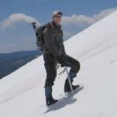
Flintster in front of yet another false summit
We reached the summit after a 5 hour ascent. The weather seemed to be holding for the moment, so we toasted to Rob and Chris and took a few pictures of the surrounding peaks.
A toast to Rob and Chris
Bear Lake in the Horn Fork Basin
For the descent, we decided to skip the east ridge with all its false summits, and decided to drop directly down into 3 Elk Creek basin. This descent is good, for the most part, because of solid grassy slopes. There was a 400/500 foot section that was rather loose, and we didn't particularly enjoy that part. But we regained gentle grassy slopes around 13,000 feet and stayed in the basin all the way until we regained the original trail at tree line.
I loved this east ridge route. We did not see a single other person all day, save for one solo climber at the summit who came up the standard route. Roach describes the east ridge as the "cardinal Colorado climb", and I would have to agree. It provides you with solitude and scenery that you normally don't get in the Collegiate Range. It was a great day to hike with my buddy, Flintster, and the solitude of this area provided the opportunity to contemplate life and how fragile it really is.
Peace to you, Rob Jansen and Chris Gray... you will always be remembered in this 14er community.
Thumbnails for uploaded photos (click to open slideshow):
Great tribute to Chris and Rob. Thanks for posting.
I really enjoyed Columbia (at this point in the sentence, most people would suggest I need to get my head checked) from Three Elk Creek a few years ago - lots of verts and mileage in a day - think we measured 12.6 mi r/t and close to 6500 ft elev gain.
I knew there had to be something better than the standard route on that one. If it weren't for big brother Harvard I think Columbia would much more appreciated.
Caution: The information contained in this report may not be accurate and should not be the only resource used in preparation for your climb. Failure to have the necessary experience, physical conditioning, supplies or equipment can result in injury or death. 14ers.com and the author(s) of this report provide no warranties, either express or implied, that the information provided is accurate or reliable. By using the information provided, you agree to indemnify and hold harmless 14ers.com and the report author(s) with respect to any claims and demands against them, including any attorney fees and expenses. Please read the 14ers.com Safety and Disclaimer pages for more information.
Please respect private property: 14ers.com supports the rights of private landowners to determine how and by whom their land will be used. In Colorado, it is your responsibility to determine if land is private and to obtain the appropriate permission before entering the property.


 left onto the trail")
 Continue across the Colorado Trail")
 a clear view of the 3 Elk Creek basin and Columbia in the distance")
")
 Flintster in front of yet another false summit")
 A toast to Rob and Chris")
 Bear Lake in the Horn Fork Basin")