Download Agreement, Release, and Acknowledgement of Risk:
You (the person requesting this file download) fully understand mountain climbing ("Activity") involves risks and dangers of serious bodily injury, including permanent disability, paralysis, and death ("Risks") and you fully accept and assume all such risks and all responsibility for losses, costs, and damages you incur as a result of your participation in this Activity.
You acknowledge that information in the file you have chosen to download may not be accurate and may contain errors. You agree to assume all risks when using this information and agree to release and discharge 14ers.com, 14ers Inc. and the author(s) of such information (collectively, the "Released Parties").
You hereby discharge the Released Parties from all damages, actions, claims and liabilities of any nature, specifically including, but not limited to, damages, actions, claims and liabilities arising from or related to the negligence of the Released Parties. You further agree to indemnify, hold harmless and defend 14ers.com, 14ers Inc. and each of the other Released Parties from and against any loss, damage, liability and expense, including costs and attorney fees, incurred by 14ers.com, 14ers Inc. or any of the other Released Parties as a result of you using information provided on the 14ers.com or 14ers Inc. websites.
You have read this agreement, fully understand its terms and intend it to be a complete and unconditional release of all liability to the greatest extent allowed by law and agree that if any portion of this agreement is held to be invalid the balance, notwithstanding, shall continue in full force and effect.
By clicking "OK" you agree to these terms. If you DO NOT agree, click "Cancel"...
Peaks Climbed: Mt. of the Holy Cross, Notch Mountain, PT 13,768, and PT 13,248 via Half Moon TH. Start Time: 7:05am End Time: 5:24pm Total Mileage: 15.2 miles Total Elevation Gain: 6000ft.
First, a big shout out to Dillon Sarnelli for providing recent beta that helped me piece together this route:
Staying true to my pattern, I looked over the Google Topographic Map on the route page of the peak to find 13ers I could add along with the 14er. There appeared to be 4 additional 13ers in the area which were attainable with some effort. The effort required turned out to be more than I expected.
How 'bout some rockin' Gregorian Chants to set the mood:
Rock on, Monks. Rock on.
There's not much to really say about the standard route, which hasn't been said before. It's a class 1 trail - follow it. On top of Half Moon Pass, I decided to take the standard route and descend to the creek since I was in need of water before continuing with my cirque route. It absolutely poured the night before I wasn't about to get out of my car to find the nearby stream to fill up my Naglene and bladder. The creek also turned out to be the only viable place to get water on the entire route. I know many people complain about having to lose 1000 vert in order to do the standard route. I get it - it sucks, but I believe many people overlook the amazing views of Mt. of the Holy Cross on this descent. When it first comes into view, it's stoic North and Face faces rise prominently above the surrounding terrain. Plus, there is a good view of a waterfall in the foreground. First view of HC on the descent to the creek.
From the bottom of the creek crossing, it's time to being gaining elevation into the dreaded "Bermuda Triangle" zone of Colorado 14ers. Take some blood pressure medication as it's an intense situation... or just follow the massive cairns built by the CFI crews. Seriously, they're Culebra-esque. Around 12,500', I passed a crew of about 12 working for CFI to continue building a well defined trail on the Slopes. Big thanks to this crews - as well as others on the other 14ers - for their continued work on building sustainable routes we use on a constant basis. Thanks, CFI.
While the CFI crew hadn't made it above 13,000ft with their trail building yet, it was easy to follow the remaining route as it just followed the ridge around the exit point of the Angelica Couloir and up to the summit. The views of the Elk and Gore range were pristine. Clear skies allowed for some excellent views (and pictures) from the Sawatch to the Elks and all the way to Longs. Compared to what Dillon described with the weekend crowd, there were only three others on the summit, all of whom ascended the standard route which told me I would have the Halo Ridge to myself. Time to summit: 3hours 30minutes View of HC from North Ridge Manpris not pictued View of the Elk 14ers. Left to Right: Castle, Conundrum, Pyramid, Maroon Bells, Snowmass
From here is when the peak-bagging extravaganza begins. The descent towards Holy Cross Ridge is much the same as the final ascent up the standard route to the summit - a loosely defined trail with a cairn here and there. After reaching the low point of the connecting saddle, I looked past Holy Cross Ridge and could see the low point for the saddle on the adjacent 13er. I knew that to tag this peak meant I had to retrace my steps, and if I were to ascend Holy Cross Ridge now, I would just have to reascend it on my return trip. I made sense to skip HCR for now and hit the bicentennial peak first.
The terrain was class 2 and for being a rather unvisited peak, there was something of a packed down route in the talus. It made life a little easier since I was afraid I would be side-hlling (something I loath) in order to circumvent HCR. Thankfully, this want not the case as it amounting to nothing more than Talus hopping. Being able to see the low point in the connecting saddle allowed me to maintain a good line.
Once I reached the saddle, I began to get in my head. The previous day and worn me out, especially my feet. I questioned if I should continue to bag this peak or just ascend HCR and make my way out since PT.13,768 looked farther away than I thought it would. Twice I stopped and really considered turning, but I knew I would kick myself later for the decision and that my mind was messing with me more than an any physical limitation. The talus also mentally affected me. While it would appear to be solid, or I would step on a large rock that looked to be secured by the others sitting on top of it or next to it, many of them would move. My shin is lacking some hair follicles from the few rocks that decided to roll and scape my leg when I stepped on them.
Staying on the ridge itself was probably a Class 2+ route in a few sections, and definitely increased the route's exposure. It was easy enough to drop down to the west side and take a slightly easier route. Near the final "pitch" up PT.13,768, the massive North face of the peak comes into view. Sheer would be a good way to describe it, and from a distance on Halo Ridge, it was reminiscent of the Diamond Face of Longs. Corssfitter and Dancesatmoonrise need to make a first ascent of this thing ASAP. The final portion of PT.13,768 was Class 2+ on solid rock that thankfully did not move when stepping on it and a quick walk to the high point with the summit register. From the summit of Holy Cross, it took me an hour to reach PT.13,768's summit. The views of the basin below, and the SE ridge were phenomenal. I was glad that I didn't talk myself out of this peak since the views made it worth the effort - my skinned shins would disagree. "Diamond Face" of Pt.13768 View of Halo Ridge from Pt.13768
The descent and traverse back to Holy Cross Ridge was straight-forward - more Class 2, nice exposure on the ridge's east side, another rock rolling over my ankle - it was all you could ask for... The ascent up the North side of Holy Cross Ridge was a quick Class 2 jaunt that offered much of the same solid rock PT.13,768's summit block had. It took me 42 minutes to traverse from PT.13,768 to Holy Cross Ridge's summit. There's plenty already written about Holy Cross Ridge and Halo Ridge that I won't waste a massive amount of space describing it. I will say that the views of Holy Cross and any ant-sized climbers on the summit make for some startling contrasts; the same can be said about using Halo Ridge; if you're feeling up to making a cirque route, I would highly recommend using Halo Ridge to add to your perspective of the mountain. Plus, it far less traveled in the summer to offer more of a "wilderness experience" (at least it offers more of a wilderness experience than Mt. Rainier's DC route can give). Holy Cross from Holy Cross Ridge
I will say that the descent on Halo Ridge, especially on tired feet is brutal; I guess that's part of the trade-off for the views. It's not the quickest terrain to move on nor does it offer constant talus stability. A few more rocks, which I swear would be solid on any other mountain decided to move when I stepped on them. My ankle and banged up shin were having enough of this. I may have left out a few verbal nasties in the sight of "God's Mountain" - oops. Mea Culpa - Catholic boy knows a little Latin. But seriously, Big Guy, can't you offer a less painful experience on something named "Halo Ridge?" Anyways, the ridge is easy enough to follow, even if the terrain doesn't want to cooperate, as the target to aim for is the Forrest Service Shelter which is in plain sight the entire time. Right before reaching the shelter, you have one up-climb to get another 13er, Pt.13,248. If it wasn't marked on the map, you'd probably not even realize that it was something of significance, but as long as you get to check it off, who cares. The (empty) Cross Couloir
The shelter allowed me to give my feet a well deserved rest and check in with the wife. BTW, cell phone reception on HC was great. At this point, I was feeling mentally drained; perhaps all the talk about the Bermuda Triangle of the 14ers was getting to me. I told Kim I would be descending from here and foregoing an attempt at Notch Mountain. That didn't happen. As I made my way on the Class 1 trail down Halo Ridge, I looked to my left and viewed the summit of Notch Mountain. It sure as heck didn't look far away and I began to reconsider. I pulled out my phone, which I used to snap a picture of Roach's topographic map (easier than carrying a paper map or book) and evaluated my options. Again, I knew that if I skipped it I would kick myself for it later on and that, distance-wise, Notch Mountain offered the shorter route with better views, so the decision was made.
Notch Mountain has two summits to it. The north one is the taller of the two and they're separated by a, well, there separated by a notch. The ascent to the southern summit is a class 2 climb with about 200 vert. I took the eastern slopes rather than the ridge just based on where i began ascending. From the summit of the south summit, what lies ahead is pretty clear and it looks somewhat daunting with the steep downlimb. I followed what I believe (afterwards) was an incorrect set of cairns. Notch Mountain is not supposed to be anything more than Class 3, but the cairns had me do a steep Class 4 downclimb on the Northeast side which would have been far more difficult if I were shorter. The exposure was also great enough to give you pause. Once I got down to the notch, I looked on the west side (facing HC) and there appeared to be a far more gradual route up. Given my disgust at the supposedly marked route, I wasn't in the mood to follow any other cairns. I saw a narrow, grassy ledge on the east sloping downward to a flat spot which lead to easier class 3 climbed up to the Northern summit. This route was far easier than what I just descended.
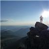
Notch Mountain is known for it's views of the Cross Couloir; they're supposed to even be better than the views at the shelter. If there was snow in there, I would have an opinion on the matter. Alas, a summer climb has it's disadvantages although it's still easy to decipher where the cross would be. Even without views of the cross, the views of Holy Cross and the Bowl of Tears (as well as Class 3 climbing) are worth it. From Notch Mountain: View of descent route.
The remaining descent follows the ridge down to Pt.12-somthing-another (who cares, it's only a 12-er). There's a faint trail on the ridge for the most part. Nearing Pt.12-somthing-another, a cairn and route descending to the east appear. Follow it. The trail switchbacks and weaves through some boulders and willows en route to rejoining the standard HC trail on top of Half Moon Pass. There are a few places were cairns disappear or the trail is harder to decipher, but with careful scouting, you can see where it continues. From the top of Half Moon Pass, it's about a 30 minute hike back to the trailhead. Thanks for reading
Topo Map - So it's not quite a ring. Deal with it.
Thumbnails for uploaded photos (click to open slideshow):
Very ambitious route hitting all of them together! I've done the loop twice, both ways, and I really prefer going the other way. Being at the shelter at dawn is something special.
Wow! Can't believe the couliors are completely dry, even this late! Someday I want to go back again and do Notch first as I missed it the last few times.
Nice choice of music too! Very appropriate in many ways.
Thanks for sharing!
Looks like you made it even more interesting. Way to add that extra peak. I will give this TR an ”acceptable” too, but the festivus, now that was outstanding! Thanks for having me man.
As long as my water supply is completely full next time I'm on this route I would definitely try going the opposite route. I've heard a lot of good things about being on the Halo Ridge in the morning as opposed to the afternoon.
Caution: The information contained in this report may not be accurate and should not be the only resource used in preparation for your climb. Failure to have the necessary experience, physical conditioning, supplies or equipment can result in injury or death. 14ers.com and the author(s) of this report provide no warranties, either express or implied, that the information provided is accurate or reliable. By using the information provided, you agree to indemnify and hold harmless 14ers.com and the report author(s) with respect to any claims and demands against them, including any attorney fees and expenses. Please read the 14ers.com Safety and Disclaimer pages for more information.
Please respect private property: 14ers.com supports the rights of private landowners to determine how and by whom their land will be used. In Colorado, it is your responsibility to determine if land is private and to obtain the appropriate permission before entering the property.


 Cross Couloir")


 Topo Map - So it's not quite a ring. Deal with it.")
 First view of HC on the descent to the creek.")
 Thanks, CFI.")
 View of HC from North Ridge")
 Manpris not pictued")
 View of the Elk 14ers. Left to Right: Castle, Conundrum, Pyramid, Maroon Bells, Snowmass")
 \"Diamond Face\" of Pt.13768")
 View of Halo Ridge from Pt.13768")
 Holy Cross from Holy Cross Ridge")
 The (empty) Cross Couloir")
 Thanks for reading")
 From Notch Mountain: View of descent route.")