Download Agreement, Release, and Acknowledgement of Risk:
You (the person requesting this file download) fully understand mountain climbing ("Activity") involves risks and dangers of serious bodily injury, including permanent disability, paralysis, and death ("Risks") and you fully accept and assume all such risks and all responsibility for losses, costs, and damages you incur as a result of your participation in this Activity.
You acknowledge that information in the file you have chosen to download may not be accurate and may contain errors. You agree to assume all risks when using this information and agree to release and discharge 14ers.com, 14ers Inc. and the author(s) of such information (collectively, the "Released Parties").
You hereby discharge the Released Parties from all damages, actions, claims and liabilities of any nature, specifically including, but not limited to, damages, actions, claims and liabilities arising from or related to the negligence of the Released Parties. You further agree to indemnify, hold harmless and defend 14ers.com, 14ers Inc. and each of the other Released Parties from and against any loss, damage, liability and expense, including costs and attorney fees, incurred by 14ers.com, 14ers Inc. or any of the other Released Parties as a result of you using information provided on the 14ers.com or 14ers Inc. websites.
You have read this agreement, fully understand its terms and intend it to be a complete and unconditional release of all liability to the greatest extent allowed by law and agree that if any portion of this agreement is held to be invalid the balance, notwithstanding, shall continue in full force and effect.
By clicking "OK" you agree to these terms. If you DO NOT agree, click "Cancel"...
I had neglected to pay a visit to Rocky Mountain National Park this summer, so it was time to return. Only two ranked 13ers remain for me in the park, and it was time to hit secluded Alice. Alice is a long day no matter how you slice it. It's hard to combine with other peaks unless you're up for a huge day. It was on the agenda a couple times with McHenry's or Chiefs Head, but weather or waning motivation foiled the plans! My friend Kierstie is working meticulously on the 14ers, so what better way to lure her into the world of ad lib on 13ers than a long hike to Alice from magnificent Glacier Gorge. Alice is usually climbed from Wild Basin, but it's actually a bit shorter mileage wise to do it from Glacier Gorge.
A 50% chance of rain necessitated a very early start. Kierstie and I carpooled from Broomfield and set out from a surprisingly busy Glacier Gorge trailhead at around 4:20. Early on I missed locating the cutoff trail that saves about a half mile or so to Mills Lake which is just past some prominent slabs after back to back bridges. We still made good time up to Black Lake and the landscape has changed drastically since my last visit. A microburst or some very high winds blew down hundreds of trees between Mills Lake and Black Lake. Luckily the park service has cleared the trail, otherwise it would be a huge undertaking navigating this mess!
There were a lot of tree roots ripped out of the ground.
Upon arriving at Black Lake, we were treated to the world class views of this impressive cirque that I will never get tired of.
Glacier Gorge from Mills Lake
Climbing Alice from Glacier Gorge is a bit of a grunt to say the least as it involves losing valuable elevation gain a couple times. One must navigate the slabs above Black Lake to Stone Man Pass. We left the trail at the stream outlet for Black Lake and bushwacked in the trees to the sea of granite slabs south of Arrowhead.
Ribbon Falls below Black Lake
There may be more than one weakness through the cliffs below Arrowhead, but we ended up a bit higher than the weakness we found when I climbed Arrowhead a few years ago. We got on an exposed ramp that I didn't feel like committing to and I spotted the easy gully above a grassy ramp just 50 feet below, so we backtracked to this easier line and picked up the route, which is sporadically cairned. The other option to Stone Man Pass is way less direct, contouring across the flats above the cliffs south of Black Lake.
Pagoda, Spearhead, and Chiefs Head rising up from Glacier Gorge
We were surprised to see a party of two camped in the cirque below the impressive Arrowhead Arete. They were prepping for an 11.a route on Arrowhead's south face. This place is truly a wonderland of glacially smoothed granite, with magnificent walls soaring above you. It is a place that inspires me every time. My Spiderman rock climber cousin had recently done an epic day of endurance alpine climbing up 2500 feet of granite on Arrowhead, Spearhead, and Chiefs Head in one day and I marveled at this achievement! Glacier Gorge is a great place to climb some amazing alpine routes!
McHenry's and Arrowhead with the Arrowhead Arete traverse.
We boulder hopped our way to the cairned trail to Stone Man. It looks sketchy from a distance, but can be kept at a loose 2nd class. We took in a much needed break at Stone Man and soaked up the views on a hot day. My body isn't used to hiking in the heat, and it felt like an oven on the steep sections even at altitude. Hate to be down in the city today!
The grunt up Stone Man.
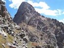
Arrowhead from Stone Man Pass.
We caught our first view of Alice, and it's a bit discouraging.
Alice from Stone Man.
You have a couple options here, and both involve a lot of boulder hopping. You can either take the gully that splits the cliffs on Chiefs Head's northwest ridge or contour below the gully and find a route up to the west ridge. The gully looks pretty nasty from afar, but it isn't bad at all. We followed grass down until it ended, then boulder hopped to the base of the gully. You could also stay higher, but it's way more tedious. Been there, done that!
Gully climb to the west flats of Chiefs Head.
The gully tops out around 12600' and from there it's an enjoyable stroll on grass until the ridge narrows to its namesake hourglass shape. We skirted some minor difficulties on the south side.
Alice looking mighty fine.
The 800' grunt to the summit of Alice was a beat down on such a hot day and it indeed laid the hammer down. I stayed at or very near the crest of the ridge to take in some nice views over the northwest face.
There is sort of a trail a bit east of the ridge, which we took on the way down. We topped out at 11:30am and enjoyed a long break as it looked like the weather might hold for a while. This was a memorable summit for Kierstie as it was her first ranked 13er and she later tells me she is going to do them all!
Looking down the north face of Alice.
The return trip to Stone Man Pass seemed a lot more tedious on the way down. I toyed with the idea of doing a repeat of Chiefs Head or Spearhead, but there were dark clouds looming over Chiefs Head. We called it a day and headed back down the gully, which seemed a lot more loose going down even though there's a trail here and there.
McHenrys from the top of the gully.
After more boulder hopping and a steep grunt back up to the pass, we were ready for another break. We heard voices coming from Stone Man Pass, but they left before we arrived. Now all that was left was the steep descent off Stone Man, and a traverse o rama across endless slabs to the land of the fairies. I felt bad unleashing a couple rocks down the gully on Stone Man, but luckily nobody was coming up this late.
Chiefs Head on the return to Stone Man.
I decided to take the longer route to Black Lake on the way down since the routefinding is easier and we didn't want to be downclimbing slabs in the rain. The trail pretty much peters out in a boulder field, and cairns are sporadic. There is no weakness that I know of on the cliffs south of Black Lake until you are almost due east of the lake. We managed to avoid the willows, weaving up, down, and around slabs and grass. The access gully finally came as thunder was rumbling above, and it started raining pretty good when we hit the trail. The rain was brief though and I was hoping it would last longer as this was the first time Mr Bluebird actually donned a rain shell this summer! Seems like as soon as you put on a shell, the rain stops! We caught up with some folks at Black Lake and it was none other than my friends Darin Baker and Terri Horvath! They had done the Arrowhead Arete on Arrowhead and McHenry's. We enjoyed their company and pumped some water at Mills Lake. On the way down, we caught the shortcut trail and popped out in the land of the tourists on the fairy trail. Another great day in Glacier Gorge!
Thumbnails for uploaded photos (click to open slideshow):
Kevin nice job. I made a long day out of Alice back in June when it was a little cooler from Wild Basin. Its such a great spot tucked away back there and its one super impressive looking peak from afar. Nice picture of Mills Lake too. well done.
I was just up there this morning... 7/23/2012 7:06pm
scouting out the area for a climb on Thursday. Yeah, the trail crews have done an excellent job cleaning out all those downed trees! Thanks for the extra info and pics of the place!
In that region of the park. Kevin, have you done Alice from Wild Basin? I'd be curious to hear which way you think is better, and more importantly, more scenic. I think its tough to find a more aesthetic area than the Lion/Snowbank lake region deep in Wild Basin below Alice/CH. Its just too bad you can't camp around there.
Thanks for the comments, folks. Brian, I have been in Wild Basin a few times, but not up to the high lakes. I still think Glacier Gorge has more mountain porn bang for the buck than Wild Basin, but they are both pretty amazing. The granite walls surrounding you in GG are a sight to behold, especially when you're right underneath them going to Stone Man. I actually think Longs is not the highlight of GG with Spearhead, Pagoda, Chiefs Head, McHenry's, and Arrowhead stealing the show. World class for sure!
Caution: The information contained in this report may not be accurate and should not be the only resource used in preparation for your climb. Failure to have the necessary experience, physical conditioning, supplies or equipment can result in injury or death. 14ers.com and the author(s) of this report provide no warranties, either express or implied, that the information provided is accurate or reliable. By using the information provided, you agree to indemnify and hold harmless 14ers.com and the report author(s) with respect to any claims and demands against them, including any attorney fees and expenses. Please read the 14ers.com Safety and Disclaimer pages for more information.
Please respect private property: 14ers.com supports the rights of private landowners to determine how and by whom their land will be used. In Colorado, it is your responsibility to determine if land is private and to obtain the appropriate permission before entering the property.


 There were a lot of tree roots ripped out of the ground.")
 Glacier Gorge from Mills Lake")
 Ribbon Falls below Black Lake")
 Pagoda, Spearhead, and Chiefs Head rising up from Glacier Gorge")
 McHenry's and Arrowhead with the Arrowhead Arete traverse.")
 The grunt up Stone Man.")
 Arrowhead from Stone Man Pass.")
 Alice from Stone Man.")
 Gully climb to the west flats of Chiefs Head.")
 Alice looking mighty fine.")
")
 Looking down the north face of Alice.")
 Chiefs Head on the return to Stone Man.")
 McHenrys from the top of the gully.")