Download Agreement, Release, and Acknowledgement of Risk:
You (the person requesting this file download) fully understand mountain climbing ("Activity") involves risks and dangers of serious bodily injury, including permanent disability, paralysis, and death ("Risks") and you fully accept and assume all such risks and all responsibility for losses, costs, and damages you incur as a result of your participation in this Activity.
You acknowledge that information in the file you have chosen to download may not be accurate and may contain errors. You agree to assume all risks when using this information and agree to release and discharge 14ers.com, 14ers Inc. and the author(s) of such information (collectively, the "Released Parties").
You hereby discharge the Released Parties from all damages, actions, claims and liabilities of any nature, specifically including, but not limited to, damages, actions, claims and liabilities arising from or related to the negligence of the Released Parties. You further agree to indemnify, hold harmless and defend 14ers.com, 14ers Inc. and each of the other Released Parties from and against any loss, damage, liability and expense, including costs and attorney fees, incurred by 14ers.com, 14ers Inc. or any of the other Released Parties as a result of you using information provided on the 14ers.com or 14ers Inc. websites.
You have read this agreement, fully understand its terms and intend it to be a complete and unconditional release of all liability to the greatest extent allowed by law and agree that if any portion of this agreement is held to be invalid the balance, notwithstanding, shall continue in full force and effect.
By clicking "OK" you agree to these terms. If you DO NOT agree, click "Cancel"...
Most of the 14ers I've climbed have been kind to me, allowing safe passage during good weather. The Blanca group has never been one of them, and Little Bear in particular has been a continual thorn in my side. One Memorial Day trip to climb Blanca and Ellingwood saw me leave with only Blanca. As for Little Bear? One winter attempt that got me to the summit of South Little Bear before snow conditions made me turn around, three planned trips postponed or cancelled due to weather, and another planned trip where the group fell apart at the last minute. Now with plans for another trip, the weather forecast was looking nearly as bad as before. I was finally realizing that Little Bear simply wasn't going to make things easy, so f$#& it--we would go and simply make the safest choices we could with what we had.
Three of us planned to meet up: Brad, I'd of course climbed with many times before, and we'd done many of the state's toughest 14ers together. Brian, on the other hand, I'd only climbed with once. While he'd never done a 4th class peak, he was a great guy with a good head on his shoulders, and we were willing to have him join us for the trip. As it would turn out, he would pass his test with flying colors, and be a great addition to the team.
Thursday, at the ugly hour of 1:30 AM, Brad and I left Longmont and headed south; Brian had family commitments that would delay his departure for another seven hours or so. By 5:30, we'd reached the base of the Como Road, ready to see how far Brad's Xterra could make it. Based on a previous Death March up that road, I'd guessed we'd make it to Jaws 0.5, optimistically getting a bit higher to a shaded camping area to the right of the road. Up we drove, making short work of the baby heads, carefully surmounting the rocky difficulties at 8800', and then finding easier progress on the switchbacks above. We reached the mini-Jaws, studied the terrain...and Brad decided to go for it! We surmounted it, and after encountering a section of road that was just too loose and steep to safely drive, parked at 10000' at a switchback. It was only 7 AM.
"I'm driving up WHAT!!?"
Overjoyed at being able to get so high on the road, and so early, we soon were on our way in the cool morning air. The valley was enchanting in the early morning light, and skies were blue. A number of deer crossed the road as we made our way up, and one of them *ahem* gave us a bit of a show...
dappled deer dropping a deuce in a decidedly delightful dale
Less than two hours later, we were at Lake Como. Given that this day was supposed to have the best weather forecast, Brad and I had planned to go for both Blanca and Ellingwood via their standard routes as insurance against potential bad weather Saturday. As long as the weather was decent Saturday, we'd gladly return and climb the peaks again with Brian then, but we were feeling fresh and ready to tackle the pair today. After quickly stashing non-necessary heavy stuff at camp, we were off, Ellingwood in our sights.
We slowly wound our way up the valley, following the good trail through rocky terrain and past several lakes. I was interested to see where the trail would go, since most of it had been buried in snow during my last trip. At the last headwall, we ran into a group of college kids doing trail improvement work, chatting with them a bit. Thanks for your hard work, guys! We reached the last small flat area where I'd started my direct climb of Blanca last year, this time turning left for Ellingwood.
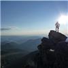
Talus abounded, but the route proved pretty straightforward. We bypassed the cliffy section at a weak spot, contending with a bit of easy 3rd class rock, then continued up the talus toward a promising-looking spot on the ridge. Making a hard push, we soon reached the ridge, traversed one or two easy bumps, and found ourselves on the summit. I was actually a bit disappointed the final ridge was as tame as it was, but we were stoked at getting a 14er that was new for both of us!
Brad topping out on Ellingwood. Those are not happy clouds! me on top, rocking the half-climber-half-beachcomber look. For you naysayers, I did have synthetic clothes in my pack
The whole time, however, nasty-looking clouds had been building, portending thunderstorms in the next few hours. While I didn't feel comfortable continuing on to Blanca that day, I was glad when Brad (who had never climbed it) confirmed my feelings. We beat a hasty retreat down the mountain. Passing the trail workers again, we let them know of the brewing storm clouds we'd seen, then hurried back toward camp. On the way, we made sure to note the turnoff for Ellingwood's Southwest Ridge route, which we hoped to climb in two days. In a meadow below the turnoff, we noticed a fox cavorting in the grass! Down we went, arriving at our stuff still sitting on the prime piece of Lake Como real estate we'd picked out. Thunder rumbled overhead as we puzzled out how to set up Brad's new 4-person tent--luckily, it turned out to be pretty straightforward. Just as we got the rain fly on, it began to hail--perfect timing! Without further ado, we moved most of our stuff inside, set up sleeping bags and pads, and both nodded off for a much-needed afternoon nap.
We had planned to meet Brian at the lake, but given his later start and inability to drive much of the road in his car, we weren't expecting to see him show up until sometime close to dark. Around 6:30, I groggily awoke, pulling on a sweater in the chilly air (is it ever warm at Lake Como in the afternoon?). Deciding it might be a good idea to wait outside so Brian would see me, I eventually poked my head out of the tent--only to see Brian truding the last few steps to the lake! Talk about absolutely perfect timing...I found out he'd had to park nearly at the beginning of the road. Also, with him never having packed in and camped overnight before, his pack was much heavier than necessary--around 60 pounds. And he'd still made it up the road well ahead of schedule! What a beast...
All of us now present, we began to make plans for Little Bear the next morning. We had already decided that none of us wanted to descend the Hourglass, a route Brad and I once swore we would never do. This left the most logical choice of a Tour de Little Bear involving a partial Southwest Ridge descent, much like Jeff had done a few months earlier. While we would still have to make the somewhat-dangerous upclimb of the Hourglass, this route would allow us to avoid two other dangers: descending the Hourglass, and being subjected to rockfall. Our plan to be at the base of the Hourglass at first light would also ensure that no parties were above us to knock rockfall down. I did not realize it at the time, but our climb would fall on Friday the 13th--perhaps not an ideal date for one of the most dangerous mountains around!
We found out that the group camped near us was also planning to climb Little Bear the next day. Chris, a solo climber from Denver, asked us if he and the two others--Casey and Blake from Missouri--could join us for the route. Brad and I were very uncomfortable with the idea of six of us being in the Hourglass at once, and we finally agreed that their group would come up half an hour later, giving us time to get up the Hourglass and most of the way to the summit. We planned for a 2:30 AM start time. After dark, Brad and I played cards a while, including such classics as "Go Bear", and Blackjack, betting with an ante of five Little Bears. Soon, we all went to sleep as best we were able.
The next morning, we set off in the dark, leaving at 2:45. Finding the waypoint I had taken for the turnoff, we headed up talus to the sketchy gully leading to the West Ridge. Slow, careful uphill progress along the right side of the gully got us to the notch, where we took a breather and enjoyed the nighttime views of the San Luis Valley. We'd noticed the other party already on their way up the gully, so we didn't linger long.
From here, we slowly picked our way along the side of the ridge, finding trail segments and cairns, only to lose them again. Lots of class 2+ and a few wrong turns later, we were nearing the base of the Hourglass. The other group had been gaining on us, and we watched them draw nearer as we gassed up on food and water. At last, it was go time.
shit just got real--in the 4th class section
I went first, with Brian in the middle and Brad taking up the rear. From the get-go, I took my time and made each move carefully, even though the initial section was only class 3. Higher up, we rounded a bend, and I could at last see the crux of the route--covered in cold, wet runoff, as we'd expected. Very carefully, we proceeded, picking our own lines, occasionally backtracking or downclimbing. At one point, I went to the right of the others, going directly up the wet stream, then trying to cut left. At one particularly scary move, I found myself with only one decent (but wet) handhold, with nearly-nonexistent footholds, and the only decent option a sloping ledge that was partially wet. For five minutes, I tried to figure something out, my hands getting colder and more numb by the second. At last, I braced myself and went for it, and thank goodness, my foothold stayed in place! My nerves somewhat shot, I upclimbed to a safer, dry area, and waited several minutes for my hands to warm. The worst was over, but we weren't out of the woods yet...
Brian and Brad negotiating the Hourglass
From here on, the route was actually pretty decent. Solid class 3 scrambling abounded, with occasional moves on looser class 2 junk. Even though the other group hadn't begun their upclimb yet, we were all especially cautious not to knock anything down--barring tiny stuff, it's doable with care. We crossed a few rock ribs, carefully making our way upward, and finally found ourselves at what looked to be the base of a gully leading right to the summit.
Brian and I nearing the summit (photo by Brad) the Mama Bear traverse, seen while topping out on the Bear
We headed straight up the easy terrain, and right as I crested the top of the gully, golden sunlight reached me for the first time all day. Within moments, around 7 AM, all of us had topped out. Little Bear was ours, and damn, did it feel good.
We took some time to relax on the summit, waiting for the other party to join us. Brad decided to explore the first part of the LB-Blanca traverse, a route he'd considered doing at some point. Ten minutes later he returned, saying there was no way in hell he'd ever do that route! I wasn't surprised--it looks freaking scary, and I have no desire to do it in this lifetime. Our next objective, the Mama Bear traverse, looked tricky but more doable. We lounged on the summit a while, relaxing and joking and taking pictures. We'd been hearing the other group for a time, but hadn't seen them; to our surprise, Chris suddenly popped over the rightmost ridge we could see, just a short distance from the summit! The other two followed soon afterward, and we regrouped. Now for the Mama Bear...
Bear Party!! (I've been waiting half a year to be invited to one) Brad, Brian, and I, relieved to have survived the Hourglass (photo from Brad)
Brad and I had a history with this part of the route, as we'd made a winter attempt of Little Bear. While I had turned around at South Little Bear, he'd somehow made it to the true summit. Thus, he was the logical person to lead the traverse. We set off in short order, six ducks in a row, going at a brisk but safe pace as Brad adeptly negotiated the ridge's difficulties. Down to the notch we went, though he then deviated from what I believe is the standard route. We passed the 4th class upclimb below on ledges, then cut back to the left to gain the crest of the ridge via class 3+ rock.
on a less-exposed ridge section, looking back at the summit. Casey is at right Brian, Casey, and I on an exposed section of ridge (photo by Brad) feeling that exposure--oh, yeah! (photo by Brad)
It was at this point that Brian grabbed an unassuming and solid-looking handhold, which broke loose and began to roll down the mountain. We all watched in horror as the head-sized boulder picked up speed, ricocheting its way down, straight into the Hourglass. Shit. All we could do was yell "ROCK!" as loudly as possible and pray that there were no parties in harm's way; luckily, there weren't. Brian was not being careless; this simply illustrates how horribly dangerous this route can be, and why we were so set on being the first group up the mountain.
the Little Bear-Blanca traverse, with Ellingwood left of center. Not in this lifetime!
The rest of the traverse ended up being surprisingly fun, and not as difficult as expected. The rock was generally solid, even on the sections where we were crawling along the top of the ridge. The exposure on the left was generally horrific, but not all that bad on the right, and ledges abounded on the latter side. There was one point where bypassing the ridge on the left was a valid option, at a slightly sloping area of rock with decent handholds. At another place, we were able to bypass several towers on an easy ledge to the right. At this point, another unfortunate occurrence: Brian's camera somehow detached from its carabiner and fell, bouncing its way down the Hourglass. Brian was understandably upset--more so at losing the memory card than the camera itself--but Brad told him that he needed to focus on the climb right now and get safely across. We mentally regrouped and continued on.
The move on the traverse we'd heard as being the scariest involves passing an unclimbable fin of rock on the right side (going south). Apparently it was class 3, but horribly exposed and loose. It turned out to be cake--the ledge was solid, easily passable, without the overhanging rock I'd expected, and with only moderate exposure. From here, it was a slightly loose class 2+ scramble to the top of South Little Bear. Within five minutes or so, we'd all reached the summit, having taken only 45 minutes to complete the traverse.
Now, clouds were building, and we knew time was of the essence. A bit more tricky terrain remained, however. The descent off South Little Bear, so scary with some snow cover, was much easier in summer conditions. We soon reached the knife edge en route to the false summit, and Brad and I immediately went for it. Unbeknownst to us, there was a very spicy move we'd somehow missed last time, which involved going across a tilted sharp knife-edged portion with essentially no footholds--you simply had to grab the edge with your hands and hope your feet wouldn't slip from under you! This may well have been the hardest move of the traverse, as we did it, and it definitely wigged Brian out. We waited for everyone to cross, and then began to high-tail it down the Southwest Ridge.
Brian, negotiating the freaky knife edge. "That JUST happened!!" (photo by Brad) Blake on the knife edge, Blanca in the background (photo by Brad)
It soon became obvious that two of our group, Chris and Blake, were lagging. We gave them a quick description of where to leave the ridge, let them know we'd leave something at the critical point, and began to book it--it would be no good for all of us to be stuck on the ridge when the almost-inevitable storms hit. The difficulty gradually eased, and in a rather astonishing two and a half hours after leaving Little Bear's summit, we were on the last ridge point at 12600'--way faster than Brad and I had descended last time! Brad and I were doing well; Brian was just behind, though his knee was starting to bother him. Casey, from the other group, was keeping up handily--impressive for a guy who'd flown in yesterday and had six 14ers under his belt! Of the other two, there was no sign...
the southwest face of Little Bear, in all its terrifying glory. South Little Bear is at center
We left a red camera bag just below the top, then began heading down the easier talus to the right. Prior to this spot, the terrain to the right was steep, cliffy, and forbidding, but our route would turn out to not be a cakewalk either. The talus was loose, shifty, and prone to sliding in spots, so I led and tried to find the least steep route of descent; this tended to be down and slightly to the left. Nearing the trees, we crossed some grassier patches, then found ourselves above a gully that at first glance looked horribly dangerous. We traversed over the top of it, now realizing that it was short, vegetated, and quite passable.
the gully that granted us passage to the valley below Little Bear Lake
A few more loose rocks and several minutes later, and we were down on the final talus slopes leading to the woods. Casey managed to get through to Blake on his phone, and we relayed the coordinates of our descent gully to him. Around this time, it began to lightly rain.
We regrouped again at 11800' in the trees, putting on rain gear and debating what to do about the other two climbers. After a bit of deliberation, we decided to continue on for now, with the plan to keep in contact with Blake and Chris. We bushwhacked through the lonely forest, making the short trip to Little Bear Lake.
Brad levitating across a meadow. Or something.
From here, we could see our ascent route, a 700' talus-hop up into a right-slanting gully.
our gully back over the West Ridge. Camp, here we come!
Though it was still lightly drizzling and the rock was slick, we made the decision to go for it--we weren't hearing thunder, and we could always turn around if bad weather hit before the top. The gully proved mostly straightforward class 2+ talus-hopping, with one choke point that should only be tricky when wet. We left one of Brad's orange karate shirts in the gully, hoping the other two would see it. I led up the gully, and was greatly relieved when it dumped us exactly at the notch in the ridge along the standard route!
Once all present, we started down, while Casey tried making a few more calls (he was unsuccessful). Down the steep gully we went, carefully trying not to knock crap down or slip. It was a relief to reach the bottom, and we were back at camp shortly after--eleven and a half hours after starting. It was an easy day for a bear.
a storm is coming...
We decided that, if the other two hadn't returned by 6:30, we'd head back up the gully to look for them. Then, we all conked out for a few hours. Around 6, we awoke to find out that the pair had just arrived back in camp--after having detoured another mile or two away from the mountain to ascend the ridge! We were relieved that everyone had made it back safely, if not in time for afternoon tea.
The three of us filtered water, then ate dinner. Much of mine consisted of "delicious" beef summer sausage, followed by Brian's actually-delicious tortillas with honey.
The next morning, we awoke slightly later, heading out of camp at 3:40. Just past the lake, our headlamps illuminated a deer that'd clearly just been sleeping in the grass. She stood, staring bleary-eyed at us, as if to say "I'm a deer, and what the freak is going on here?".
Brad and I were planning to do Ellingwood's Southwest Ridge, but as his nerves were shot, Brian decided to tag along with a group heading up the standard route for one member's finisher. We split above the first set of switchbacks, and Brad and I made it up the rocky couloir to the ridge crest around 12900'. We may have taken the "wrong" branch of the couloir, ending up in a notch, but it proved not to be a significant obstacle. We both had some much-needed food and then began, seeing what the ridge held in store.
typical Southwest Ridge terrain
Overall, this route is a classic: it's replete with class 3, mostly solid, and horrifically exposed in many spots. I'd call it only slightly easier than the Mama Bear traverse, but two and a half times in length; it's comparable to a tougher climb of Kelso Ridge, minus the easy sections. If you're starting fresh, it's a blast; for Brad and I, it was about as tough as we could mentally handle after yesterday's adventures.
I led most of the way, working largely off of my own route-finding skills; we hadn't brought along a detailed route description. The first section was replete with tricky, narrow ridgetop scrambles, as well as a bypass of a cliffy wall with some Eolus-like ledge scrambling. At a notch, we encountered some of the toughest and least-obvious scrambling (class 3+ at least), after which the difficulty eased for a while. About halfway up, the sun popped up from behind the mountain, making it difficult to see the terrain ahead. The last 400' or so up Ellingwood looked challenging, though we wouldn't know until we got there--much of what looks difficult on this route turns out to be easy, and vice versa.
Brad just being his typical BAMF self on a knife-edgy part of the ridge Little Bear's east side lit by the sun. "Damn Little Bear, you scary!" "This is cake, man!"
Nearing the final summit climb, we saw a steep, dramatic section of ridge with a sheer dropoff to the left; this proved to be one of the only parts of the ridge where the best route involved dropping well below the crest. We found cairns, and even trail segments here, but then the obvious way disappeared. We could see a red gully ahead leading to a notch on the ridge, and the last steep climbing of the day, but had a hell of a time getting over to it. The ridge crest proved too sketchy and exposed, so we painstakingly looked for ways across the steep rocky ribs and loose gullies before the notch.
me, trying to figure out the last section before the summit (photo by Brad)
After some scary and frustrating route-finding, we reached the notch. It wasn't obvious how to proceed from here, so we just started up, making a few moves on flaky rock. Past these, the rock became solid and easier, then class 2+, then class 2, and with little fanfare, we found ourselves at the far end of Ellingwood's summit ridge!
what we spent the last two and a half hours doing...
A few minutes of easy talus-walking brought us back to the top, less than 48 hours since we'd last been there. The Southwest Ridge had taken us two and a half hours from notch to summit. We could see several parties on Blanca, but we didn't know where Brian was.
Brad and I were anxious to get to Blanca, which he still needed, so we left shortly after. This time, we were a bit better at finding the standard route on our descent, but it still was often difficult to follow. We were planning to try the 3rd-class traverse option, and we found a promising initial ledge that quickly petered out. Two climbers below us were passing in the other direction, so we backtracked and found an obvious cairned route where they'd gone. While it held a few class 3 moves, it was surprisingly easy, with some lengthy trail segments. The trail took us below a large group congregating near the saddle, and from there, we followed talus up to the ridge. The standard route up Blanca awaited, and the clouds were starting to build yet again.
We judged that there'd be plenty of time to safely summit, and so started ahead at a brisk pace. Meanwhile, the large group that'd been above us were making their way across the traverse, higher than where we'd been, choosing their own routes and generally making a ruckus. "I'm going to go this way!" "Who the fuck cares!?". Pleasant group...
Up we went, following trail segments interspersed with talus-hopping. The rocks here were wet from yesterday's rains, and not yet in the sun, so care was required. At one point, we saw what looked to be Brian, heading down Blanca off the standard route with two other guys. It was him, and we agreed to just meet back at camp.
Brad and I continued, staying to the right of the class 3 options near the top of the ridge, finding trail segments that took us to just below the summit. We topped out to hazy views and building clouds, an hour and a half after leaving Ellingwood, and completing Brad's Sangre de Cristo 14ers.
3 for 3! Brad and I atop Blanca...but we all know who the real star of the show is
I made him take the two-minute side trip to tag the Huerfano County highpoint, back along the ridge leading to Ellingwood. At 10:20, we began to descend. We passed several parties still heading up (at this point, not a stupid decision, though I hope most of them didn't stay too long on the summit). We ran into Chris again and chatted a few minutes. Near the base of the mountain, the route became nebulous, and it took us a few minutes to find the start of the tricky switchbacks on the steep slopes above the trail workers. However, find it we did, and we were soon passing the trail workers, the tricky terrain over. We booked it back to camp as quickly as we were able, still having to take occasional rest breaks.
our Southwest Ridge route on Ellingwood, looking totally nuts (photo by Brad)
We rolled into camp around 12:45, finding Brian mostly packed up. After a short rest, we broke down the tent, packed our stuff, and were ready to go. We marveled at a couple of Jeeps rolling into the lake area, friendly folks who'd brought their dogs. One of them gave us a cold liter of water. We also found out that Casey had spent part of his rest day actually hiking back up and over the notch to retrieve Brad's shirt he'd left as a marker for the other guys the day before. Thanks, Casey!
At 1:45, we began booking it down the loose, crappy Como Road, as peals of thunder and threatening clouds loomed overhead. We didn't mind a little rain, but hoped it wouldn't get too bad and make the drive back down the road even more dangerous. Two other climbers heading down at about the same pace met up with us, and we agreed to give them a ride down along with Brian. On the higher parts of the road, we found ourselves constantly having to step off to the side as yet another Jeep or ATV grunted their way up the road; it brought back unpleasant memories of Antero. Back in the thicker trees, it started lightly raining.
Finally, we reached the short uphill stretch on the road, and knew the end of the hiking was imminent. By about 3 PM, we'd reached Brad's vehicle, and in only five or ten minutes, we'd all piled ourselves and our gear inside. Now all we had to do was get down, then to Alamosa, where Mexican food awaited!
At Jaws 0.5, we all piled out, and I guided Brad down the rocks as several others hiking up the road watched. Past that obstacle, we ended up just in front of a group hiking down, who we let pass--they'd prove to be slightly faster than us the whole way down. Lots of people were trudging up or down the road on this Saturday afternoon, and all of them looked miserable. Luckily, we didn't run into anyone driving up the road this late in the day, and so we made good time downhill. We made it through the shitty section at 8800', the Xterra's front guard picking up one or two dings in the process, then made it onto safe ground on the baby heads. Whew! We dropped the two other guys off, then Brian lower down at his car, and caravaned into Alamosa. We headed straight toward Calvillo's, the Mexican buffet place I'd eaten at last year, and had been fantasizing about ever since. It was everything I'd remembered. As my hiking partner on my previous trip had said, you have to earn eating here. And we certainly did--several times over.
An hour later, we waddled out, stuffed to the gills. After saying our goodbyes, we began the long drive home, but could rest easy in knowing that all three of us had had an amazingly successful trip. And that we'd never have to go up that infernal road ever again.
a stormy parting shot of the Blanca group, with Little Bear again stealing the show. I'll be back...for Lindsey, anyway
Thumbnails for uploaded photos (click to open slideshow):
Thanks! I'm relieved to have them behind me...as for the anchor, it's still in place, I don't know how good of condition it's in, though. I remember seeing only one piece of webbing that looked relatively new. The rope that's in place seems to have been put in fairly recently, but someone else mentioned that it'd lost a part of its outer casing already, so I wouldn't place all your trust in it. None of us used the rope on the ascent.
Anna--driving up to 10k on the road made that approach about a million times less unpleasant! And I'm sure that traverse is quite the adventure, but I may just have to save it for more hardcore people like you ;)
Lemmiwinks--he's, uh, leaning on that other bear for moral support! (what happens on Little Bear, stays on Little Bear)
Brad--thanks for going back for the Bear Party with me. It was an epic trip, and we made it all work somehow...
I don't know if the gully you used to descend was the same as ours, but I hope not. Talk about misery, haha. Thanks for the kudos, Brad, and congrats to all on a fine trip to the Sangres. I still have to return to the area one more time for Blanca. It'll be my fourth trip up the road.
I don't think it was the same one, as it was only about 100' tall, and not really any worse than the other gullies on the route--we made it most of the way toward the valley on talus fields.
You poor bastard...I forgot you've been up that awful road so many times! Here's to next time being the last!
Nice TR Chris! Hope to climb with you again sometime! If it's alright, I might add a couple thoughts rather than write up the shortest TR. Having led our group above the Hourglass, I liked the terrain on climber's far left. I'd call it mostly class 3 with an occasional more difficult move but all solid and less risk of sending rocks down the Hourglass. I don't recall much immediate exposure.
On my mission to save Brad's shirt (second and third time through the gully on the Little Bear basin side), I found the rock rib (climber's right ascending) to be more enjoyable and stable than the gully itself. As Brad had done the day before, I climbed out of the gully at the narrowest point.
-Casey
For a guy with no car, you sure get around 7/17/2012 1:59am
Wow, Chris. From Gannett to Little Bear, it's hard to gauge whether your best stuff of 2012 has even gone down in Colorado.
In the midst of a superlative TR covering three 14ers, we get the true Chrisinaz:
”I made him take the two-minute side trip to tag the Huerfano County highpoint.” Big surprise...
Great stuff, man!
Chris, as proud as I am, I am shocked and dismayed at your foul language. I have never heard you swear like this in person before, it's not befitting a soon to be doctor. Fortunately, the Jesus Bear will be accompanying us on the Crestones traverse and will hopefully moderate your foul mouth...
P.S. and yes you earned that buffet
in image #15 sure brings back memories when we did the SW Ridge of LB. My brother took one look and said he'd had enough. My nephew flew across it, no problem. I stood there staring at it for several minutes and finally got the nerve to cross it. Still get sweaty thinking about it! Great report, thanks.
Rob--thanks, we got the idea for the general route from you guys!
Casey--thanks for the extra beta. It was great climbing with you, and feel free to give us a shout next time you're in CO!
Matt--do you really think I would let Brad go back down the Como Road without tagging it--especially after introducing him to LoJ? ;)
Brian--I'll try not to offend the Jesus Bear's delicate sensibilities. It'll be easier if the rock isn't wet...
painless--that move was certainly airy, and I wasn't really expecting it (I still have no idea how I missed it the first time!). Glad you made it up on your climb.
Just thought I'd comment, great report, will be heading to do Blanca/Ellingwood in August, I'll save Little Bear for another time and may do exactly what you guys did for the decent
Congratulations on making all three!
I'm curious, what's the state of the anchor that the rope in the hourglass is tied to?
Caution: The information contained in this report may not be accurate and should not be the only resource used in preparation for your climb. Failure to have the necessary experience, physical conditioning, supplies or equipment can result in injury or death. 14ers.com and the author(s) of this report provide no warranties, either express or implied, that the information provided is accurate or reliable. By using the information provided, you agree to indemnify and hold harmless 14ers.com and the report author(s) with respect to any claims and demands against them, including any attorney fees and expenses. Please read the 14ers.com Safety and Disclaimer pages for more information.
Please respect private property: 14ers.com supports the rights of private landowners to determine how and by whom their land will be used. In Colorado, it is your responsibility to determine if land is private and to obtain the appropriate permission before entering the property.


")

")
")

")
")

")
")


")


")

 \"I'm driving up WHAT!!?\"")
 dappled deer dropping a deuce in a decidedly delightful dale")
 Brad topping out on Ellingwood. Those are not happy clouds!")
 me on top, rocking the half-climber-half-beachcomber look. For you naysayers, I did have synthetic clothes in my pack")
 shit just got real--in the 4th class section")
 Brian and Brad negotiating the Hourglass")
 Brian and I nearing the summit (photo by Brad)")
 the Mama Bear traverse, seen while topping out on the Bear")
 Bear Party!! (I've been waiting half a year to be invited to one)")
 Brad, Brian, and I, relieved to have survived the Hourglass (photo from Brad)")
 on a less-exposed ridge section, looking back at the summit. Casey is at right")
 Brian, Casey, and I on an exposed section of ridge (photo by Brad)")
 feeling that exposure--oh, yeah! (photo by Brad)")
 the Little Bear-Blanca traverse, with Ellingwood left of center. Not in this lifetime!")
 Brian, negotiating the freaky knife edge. \"That JUST happened!!\" (photo by Brad)")
 Blake on the knife edge, Blanca in the background (photo by Brad)")
 the southwest face of Little Bear, in all its terrifying glory. South Little Bear is at center")
 the gully that granted us passage to the valley below Little Bear Lake")
 Brad levitating across a meadow. Or something.")
 our gully back over the West Ridge. Camp, here we come!")
 a storm is coming...")
 typical Southwest Ridge terrain")
 Brad just being his typical BAMF self on a knife-edgy part of the ridge")
 Little Bear's east side lit by the sun. \"Damn Little Bear, you scary!\"")
 \"This is cake, man!\"")
 me, trying to figure out the last section before the summit (photo by Brad)")
 what we spent the last two and a half hours doing...")
 3 for 3! Brad and I atop Blanca...but we all know who the real star of the show is")
 our Southwest Ridge route on Ellingwood, looking totally nuts (photo by Brad)")
 a stormy parting shot of the Blanca group, with Little Bear again stealing the show. I'll be back...for Lindsey, anyway")