| Peak(s): |
Mt. Massive - 14,427 feet "North Massive" - 14,337 feet "Massive Green" - 14,311 feet "South Massive" - 14,157 feet |
| Date Posted: | 07/13/2012 |
| Date Climbed: | 06/23/2012 |
| Author: | TaylorHolt |
| Additional Members: | Big Schwimm |
| Peak(s): |
Mt. Massive - 14,427 feet "North Massive" - 14,337 feet "Massive Green" - 14,311 feet "South Massive" - 14,157 feet |
| Date Posted: | 07/13/2012 |
| Date Climbed: | 06/23/2012 |
| Author: | TaylorHolt |
| Additional Members: | Big Schwimm |
| Massive Mania |
|---|
|
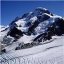
Trailhead: Windsor Lake (ascent), Mt. Massive (descent) Route: Massive Mania (North Ridge ascent, South Ridge descent) Start Time: 8:00 am Finish Time: 6:00 pm I arrived at the Mt. Massive TH at 6:45 to find my climbing partner, Seth, patiently waiting and ready to set up our shuttle to the Windsor Lake TH. He hopped in my car, and we headed of in search of Windsor Lake TH. I say "in search" because neither of us knew exactly where it was. This proved to be problematic when we drove past the trailhead turnoff and didn't realize it for about ten minutes. For anyone reading this for trailhead beta from Leadville, the turnoff for Windsor Lake trailhead is a dirt road on the left hand side of the road before you reach the Mary Queen Campground. Anyway, we backtracked and finally found the right turnoff that would lead us up to Native Lake TH and Windsor Lake TH. This confusion cost us about a half hour, and we headed up the trail to Windsor Lake at 8 am, later than we intended. The one mile up to the lake went by very quickly and we arrived in what seemed like no time at all. The trail led us around the northern shore of the lake and past the Hagerman Tunnel, a collapsed railroad tunnel that was the highest railroad tunnel in the world at the time of its construction. From the western side of the lake the path became a "pick-your-route" boulder hop up to the ridge. The boulders eventually turned into loose scree towards the top, but we made quick work and reached the ridge in about 20 minutes.   Once we gained the North Ridge of Mt. Massive, the entire route was laid out in front of us. Despite the fact that we could see the summit, it was still miles away. This began our long tundra march along the ridge towards 13,000 ft. The ridge was a gradual uphill slog that consisted of a few ups and downs over "ridge bumps," some of which can be contoured around. As we were walking up the tundra, I looked to the east and caught our first glimpse of the Treasure Fire. It looked small at first, but with the windy and dry conditions, I knew I could quickly grow, and we watched it do so throughout the day.    The remaining hike up North Massive was long but technically easy. The wind picked up quite a bit, but with the hot conditions expected, it didn't feel too bad. I particularly enjoyed the view to the west during this section of the hike. We were not only able to see the nearby Sawatch 13ers but also the entire Elk Range. When we reached the summit, I opened the summit register canister only to find a soggy wet paper ball inside that when ripped to shreds when I attempted to remove it. Oh well.      The most technically difficult section came between "North Massive" and "Massive Green," as a class III gendarme between these summits presented us with some challenges. We were unsure of the exact route, but I remember reading that it's best to stay just on the east side of the gendarme. As we made our way around to the east, we ran into a snowfield, that was relatively narrow, but very long (approx 400 vertical ft from top to bottom and we were near the top). Since neither of us brought any snow gear and there were no tracks to follow, we decided to climb over to the west side of the ridge and give that a shot. We tried a couple different routes but kept getting cliffed out. As a result, I began to reconsider that crossing the snowfield may actually be our best option. A fall on the snow could have easily resulted in injury, but the downclimb around the base of the snowfield would have been a major detour, so I decided to at least try it out by kicking a few steps. As expected on a warm day, the snow was very soft and I postholed nearly the entire length of my leg. This made travel slow, but I at least knew that my footing was pretty secure. Once I was about two thirds of the way across, Seth followed my tracks and made it across much faster. The trail reappeared after the snowfield, and the rest of the route was easy to follow up to the summit of "Massive Green." Since our ultimate goal was so close (it literally looked like a stone's throw away), we only spent a few minutes atop "Massive Green" before following the trail onwards towards Mt. Massive.  As I was leading the way down Massive towards "South Massive", I hear Seth behind me exclaim in despair "Uh Oh..." followed by "We have a problem." I turned around not knowing what to expect really, perhaps he suffered an injury?!? I hesitantly ask what's wrong, and Seth responded, "I left my keys in your car." I was at first relieved but then realized what a significant inconvenience this would provide. Our shuttle was not only useless but was now a hindrance. Hiking from one trailhead to the other certainly wasn't an option, and we were too far down the south side of Massive to head back over to the north ridge. By process of elimination, we decided that relying on the kindness of strangers at the trailhead to give us a ride back to my car was our best option. From this point forward, I knew we had to set a fast pace the rest of the day because it was already late in the afternoon, and we would have more ride options the earlier we got back to Mt. Massive TH. The remaining route on the south side of Mt. Massive was comparable to the north side, a lot of ups and downs on a class II ridge. We quickly summited "South Massive" and Pt. 13,630 ("South South Massive") and then began the long steep tundra walk down to Pt. 12,381 (this was the most annoying section of the hike, can't imagine having to go up that section). Just below Pt. 12,381 we finally reached treeline again after about 9 hours above it. The "route" from here: bushwack through the trees on an easternly bearing until you reach the Colorado Trail. Judging by the map, I figured we would run into the trail at around 11,000 ft, and Seth's altimeter helped us judge our progress through the trees. After about 45 minutes of bushwacking, we were back on the trail and headed for Seth's locked Jeep. When we returned to the trailhead, the search emediately began for a ride back to Windsor Lake TH. We were happy to see a multiple people still in the parking lot. After evaluating the scene, Seth figured our best chance was to ask the guy leaning against his hatchback drinking a beer. When we first approached him (his name was Chris), he initially assumed we wanted food or beer, but agreed to give us a ride since he was waiting on a couple of friends to join him from Denver. Turns out he had climbed Belford and Oxford that day and was camping at the TH to climb Massive the next day. We hopped in and took the twenty minute "stranger shuttle" back to my car. We located Seth's keys, and I drove him back to the Mt. Massive TH, ending a long but rewarding day on the Massive Massif!   Thanks for the invite Seth, and thanks for the ride Chris. Thumbnails for uploaded photos (click to open slideshow):  Windsor Lake")
 Mt. Massive comes into view")
")
")
 Seth taking in the remaining route")
")
 Seth working his way up North Massive with the majority of our route in the background")
")
 The view west to the Bells and Snowmass")
 Final stretch up North Massive")
 North Massive summit photo")
 North Massive summit photo")
 Summit photo on Massive")
 Summit photo on Massive")
")
")
")
")
")
 Treasure Fire")
")
 Mt. Elbert")
 Pt. 12,381")
 Arriving at the vehicle that we can't get into")
 Enjoying the sunset behind Massive on my drive back to Buena Vista")
|
| Comments or Questions | ||||||
|---|---|---|---|---|---|---|
|
Caution: The information contained in this report may not be accurate and should not be the only resource used in preparation for your climb. Failure to have the necessary experience, physical conditioning, supplies or equipment can result in injury or death. 14ers.com and the author(s) of this report provide no warranties, either express or implied, that the information provided is accurate or reliable. By using the information provided, you agree to indemnify and hold harmless 14ers.com and the report author(s) with respect to any claims and demands against them, including any attorney fees and expenses. Please read the 14ers.com Safety and Disclaimer pages for more information.