Download Agreement, Release, and Acknowledgement of Risk:
You (the person requesting this file download) fully understand mountain climbing ("Activity") involves risks and dangers of serious bodily injury, including permanent disability, paralysis, and death ("Risks") and you fully accept and assume all such risks and all responsibility for losses, costs, and damages you incur as a result of your participation in this Activity.
You acknowledge that information in the file you have chosen to download may not be accurate and may contain errors. You agree to assume all risks when using this information and agree to release and discharge 14ers.com, 14ers Inc. and the author(s) of such information (collectively, the "Released Parties").
You hereby discharge the Released Parties from all damages, actions, claims and liabilities of any nature, specifically including, but not limited to, damages, actions, claims and liabilities arising from or related to the negligence of the Released Parties. You further agree to indemnify, hold harmless and defend 14ers.com, 14ers Inc. and each of the other Released Parties from and against any loss, damage, liability and expense, including costs and attorney fees, incurred by 14ers.com, 14ers Inc. or any of the other Released Parties as a result of you using information provided on the 14ers.com or 14ers Inc. websites.
You have read this agreement, fully understand its terms and intend it to be a complete and unconditional release of all liability to the greatest extent allowed by law and agree that if any portion of this agreement is held to be invalid the balance, notwithstanding, shall continue in full force and effect.
By clicking "OK" you agree to these terms. If you DO NOT agree, click "Cancel"...
South Wilson-14,110 feet (An unranked 14er .35 miles south of Mt. Wilson)
Climb Date: 08 June, 2012
Crew: sgladbach (Steve), globreal (Britt)
Mileage: 12.5 miles (plus side trips to West Wilson & Mt. Wilson-not mentioned in this TR)
Vertical Feet: 4,000+ (We did over 5,000 feet with our other peaks)
Trailhead: Kilpacker Basin, 10,100
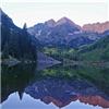
South Wilson is one those "unranked" 14er points that doesn't have the required 300 feet of prominence from it's adjacent peak to make the official list of ranked 14ers. In the above photo, you can see South Wilson from the Kilpacker trailhead parking lot. It's the peak with the sliver of snow on it in the upper right portion of the photo. (That's El Diente, upper left in shadows.)
Soon after Bill Middlebrook added the unranked 14ers to the list of ranked 14ers here on 14ers.com....well, I knew I wanted to go after them. For some reason I personally just wanted to be able to say, "I've climbed all the 14ers" without adding any qualifiers or definitions.
The first time I climbed El Diente and Mt. Wilson in June 2010, I didn't know about the neighboring unranked West Wilson and South Wilson. A year later in September 2011, I was back for these two peaks. However, a friend I was leading to the summit of El Diente wasn't feeling well. So, I knew I needed to escort him back down to the bottom of the basin. I therefore missed out on the El Diente-Mt. Wilson traverse with Tommy Driscoll where I would have picked up West Wilson. Once my friend was back down safe and and resting, I then headed up to meet up with Tommy coming off of Mt. Wilson. We then went to try for South Wilson. However, we learned that what looks like the easiest route isn't always the easiest route and we didn't end up getting South Wilson. I'll explain all that later.
I knew I wasn't coming back in winter for these two Wilsons, so I had so sit on my laurels for almost a year before finishing off these last 2 peaks and thus reaching my goal of climbing all of the 14ers.
I discussed the idea of going after these two unranked Wilsons' with my friend Steve Gladbach during our winter climb of Phoenix Peak together. He said he could join me over the second weekend in June. Our date was pretty much set all the way back in February, 2012.
Now, if you don't know where South Wilson is, you are not alone. This peak has not seen many visitors. It's on the south ridge coming off of it's famous parent peak; 14er-Mt. Wilson. The basic route for South Wilson isn't to difficult. You start at the Kilpacker trailhead. You can follow the route description from here:
However, at 12,600 feet, instead of following the route (in the 14er.com route shown in the link above) to El Diente, continue on east further up into the basin. (See map below.)
Once you get above treeline and above the big waterfall, you will be able to see South Wilson straight ahead of you. (You can't see Mt. Wilson yet. It's hiding upper left out of frame and behind the ridge in the foreground.)
As you continue deep into the horseshoe shaped basin, you will eventually see this big imposing set of cliffs. While South Wilson is up and to the right behind those cliffs, you must get to the top of those cliffs by climbing just to the left (north) edge of them where you can see a snow path in this photo.
If you have snow, you'll want crampons as it gets moderately steep here. If the snow has melted out, climbing the large talus/boulders isn't to bad. They were pretty stable in my opinion when I climbed that section last September.
Up above that set of cliffs at 13,000, you get a nice view of the saddle between South Wilson (left) and Pt. 13,777 (right).
Steve is making his way across the somewhat flat shelf, above those cliffs with the El Diente-Mt. Wilson traverse-ridge behind him to the north.
Now this is where I got suckered back in September 2011. Tom and I took what looked like the easiest route....up the smooth, yet steep slope to the saddle. You can see our earlier attempted route in green, from this photo taken over on El Diente looking southeast. photo by Ken Nolan
Ken Nolan has climbed this peak and gave me his route info. (For those who don't know who Ken Nolan is...he is a legendary climber in the state of Colorado who has climbed most of the states' highest 2,000 peaks!) He ascended the red route and descended the blue route shown in the photo. Take note, at the top of the big major cliff band, instead of turning right immediately above those cliffs and aiming straight for the saddle as our route shown in green, you'll want to angle on up to a second shelf as shown in red. You can see this second shelf by the big brown spot and steep area between the green and red lines.
To follow Ken Nolan's red route, this is what you will want to look for. It's what I call "the knob." It's the high point that sticks up above the ridgeline as you look left from the saddle over towards South Wilson. That's the shortest and "easiest" (relative term) gully up to the ridge.
This is the view at the base of "knob gully," looking west toward Pt. 13,777.
When I said "easiest" I didn't say it was easy! This gully is like walking on broken dinner plates!!! I went up the right side of "knob gully" as shown here. Steve went up the left. We didn't want to be below each other in case of rock fall. photo by sgladbach
Walking on broken dinner plates. Can you just imagine the brittle, ceramic sound that would make? That's what it sounds like and that's what it feels like on this stuff!
Here's how Ken Nolan described it to me: "Everything is
hideously loose and insecure." Steve found that out the hard way! (Sorry Steve, don't we need to show people what it's really like?)
However, as I mentioned, from the point where we got off of snow and onto the "broken dinner plates" it was a short climb. It only took us about 10-15 minutes to climb up through this loose stuff up to the ridge. photo by sgladbach (taken during our descent)
Now, go back in time with me to September 2011. When Tom and I made it to the ridge at the easier looking saddle, (to the right of "knob gully") we turned left and headed up toward South Wilson. It started out just fine, until we encounter this....
Remember what Ken said about "hideously loose?" Remember my wording of "broken dinner plates?" Marry those concepts, with "knife edge" and "exposure!" Tom and I made it across two sections of knife edges and we believed there were at least two more to go. It was hard to tell with the fog and with "the knob" blocking our view on up to the summit. Combine all that with fog, wind, snow and now sewing machine legs!!! We called it. We turned around and went home.
Now, imagine my surprise when Steve and I reached this ridge on June 8th, 2012 and saw this!
With Ken's beta, we nailed it! We are past all the knife edges and it's an easy path to the summit. Yoo hoo!
But first, Steve came over to investigate the knife edge that was beside us. That's "the knob" I mentioned between Steve and Pt. 13,777. I made to the ridge up and out of "knob gully" right where I am standing taking this picture. What's hard to get perspective on is the steepness of the drop from those knife edges. A fall off one of those would not be pretty.
So, I can't tell you how overjoyed I was to be looking up at the summit and not seeing knife edges and loose rock! photo by sgladbach
I though this view looked a lot like the ridgeline up to Southwest Little Bear from the southwest ridge route.
Steve is making his way up the ridgeline. This is such a nice hike at this point.
Looking off to the right (east) is a great view of Lizard Head Peak (13,113) dubbed as Colorado's hardest 13er to climb.
However, our work isn't hard right now. I am loving this hike. What a stellar day to be out climbing. That's "the knob" and our approach gully just behind my right shoulder. Note, last year during my attempt, I reached the ridge to the saddle where the rock color is beige...just above that snow patch. photo by sgladbach
The route on up to the summit gets a little bit steeper the last 100 feet or so, but it's still delightful as it's no where near as loose as in the "knob gully."
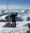
And once we reached the summit, we were met with this spectacular view of Mt. Wilson just a 1/3 of a mile away to the north.
I'd be curious to hear how it is on the scramble from Mt. Wilson to South Wilson. There are a few spots where you just can't see if it will go or not. My guess is someone will try it before to long. And when they do I hope they will let us all know what it's like on this traverse.
Now, I mentioned earlier that this is a lonely peak with not many visitors. Since October 16, 2009, only four different people had come to see her and sign in. Me and Steve were number 5 and 6.
There was not a cloud in the sky on this glorious day and it was wonderful to be on a new summit that neither of us had ever visited. (For those of you who know Steve, can you imagine?)
On the way back down, we noticed a nice gentle slope descending off the ridge to the east. And it's a very mild slope all the way down to State Creek Basin below.
If someone wanted to climb South Wilson only, a shorter route (5 � miles one way instead of 6 � miles via Kilpacker) could be had by starting at Lizard Head Creek. This starting point would be about two miles southwest of Lizard Head Pass on CO 145. There is actually a trail shown on the map from Lizard Head Creek that will take you over to the State Creek Basin. Then you could come up that gentle slope shown in the photo above. (Disclaimer. I just viewed this on an online map, I've not done this route and so you'll have to do your own research.)
If you wanted to stick with the Kilpacker Basin route, then I would suggest as Ken Nolan did to me: "Consider a spring attempt when snow might at
least approach the ridge crest." Had Steve and my schedules been able to come do this climb in May, I think it would have been a blissful snow climb. photo by Ken Nolan
And again, you can see Ken Nolan original route via "the knob gully" shown in red. Steve gave Ken's blue line descent route a go, but it's longer going that way. photo by Ken Nolan
Maybe this TR will bring some more visitors to this lonely, neglected peak. Steve, thanks again for going with me and helping me finish my goal of climbing all the listed 14ers in Colorado.
Thumbnails for uploaded photos (click to open slideshow):
Great finish to an amazing journey! 6/13/2012 3:05pm
Wow, Britt. This report really captures the remoteness of what you've accomplished. Thanks so much for sharing your story with us all over the years. So inspiring, buddy. Here's to many more journeys to come! -Dan-
as always Brit! I may give this one a try, but may scope out the gentler route you discovered. Thanks for the information and again, congratulations on completing, without questions or caveats, ALL the 14ers!
Britt, you have shown yourself to be a great mentor and example of how with God, all things are possible. From my first real 14er at Shavano, where you took a chance with this Missouri flatlander, you have inspired me to follow you up the peaks. God has honored your careful planning, emphasis on safety, constructive post-climb analyses (always trying to improve your technique while leading others), and reliance on God as evidenced by your faith and prayers to the God of the Bible, which are always the first thing to ascend heavenward at every trailhead. As the tired September 2011 friend you mentioned above, I watched you and Tommy from the horseshoe basin below make your first attempt until the crazy fog and groppel set in. It seems fitting that your finish this week was picture perfect. God is good-and I am humbled to be your friend.
Congrats, Britt, on your accomplishment. Great TR too.
I believe in the CMC book Roof of the Rockiesthe traverse from S. Wilson to Mt. Wilson was attempted by the Wilson geological survey team during the first attempted ascent. The surveyors came to a prominent, loose low 5th class gulley right before Mt. Wilson and called it quits from there.
I believe this is correct, it may have been another route though.
On 8/25/12, I summited S Wilson following the knob gully route. I used your topo map to setup the knob waypt which you show at ~13860'. I tried to confirm this in Google Earth, but it did not look right. I found the knob to be at 13620'. Sure enough, my GPS track confirmed this. Can you take another look at your map route. I ascended the knob gully, but sure did not like the steep loose finish. So much so, I decided to descend the ridge to the saddle. You sure were right about this. That knife ridge was the worst thing I've ever been on. There is a 15' section where you cannot do anything but scoot your butt across, and pray the whole thing does not collapse. If it does, there will be nothing to try to cling to - just go down with the whole mess most likely to your demise. An angel was with me that day!
Congrats on getting this lonely peak! What were you, the 9th person to sign that register?
That route on the map was hand drawn, not from a GPS. So, it's not to be taken literally...just to give the big picture. Thanks for documenting the elevation of the ”knob.” I didn't think to take a reading.
Yep...don't like that brittle knife edge! I'd prefer to slide back down some broken dinner plates than fall off an exposed ridge!
I did peek down the blue descent route to the N which did look more appealing, but did not go since did not know for sure how it would go. I was the 9th entry & person to the register, 10th summit. Tommy Driscoll on 6/25 & Greg Fischer 8/18 (see his TR on 5th class Wilson traverse at this site) in bewteen you & me.
Caution: The information contained in this report may not be accurate and should not be the only resource used in preparation for your climb. Failure to have the necessary experience, physical conditioning, supplies or equipment can result in injury or death. 14ers.com and the author(s) of this report provide no warranties, either express or implied, that the information provided is accurate or reliable. By using the information provided, you agree to indemnify and hold harmless 14ers.com and the report author(s) with respect to any claims and demands against them, including any attorney fees and expenses. Please read the 14ers.com Safety and Disclaimer pages for more information.
Please respect private property: 14ers.com supports the rights of private landowners to determine how and by whom their land will be used. In Colorado, it is your responsibility to determine if land is private and to obtain the appropriate permission before entering the property.


")


")
")
")
")
")
")
")
 photo by Ken Nolan")
")
")
 photo by sgladbach")
")
")
 photo by sgladbach (taken during our descent)")
")
")
")
")
 photo by sgladbach")
")
")
")
 photo by sgladbach")
")
")
")
")
")
 photo by Ken Nolan")
 photo by Ken Nolan")