Download Agreement, Release, and Acknowledgement of Risk:
You (the person requesting this file download) fully understand mountain climbing ("Activity") involves risks and dangers of serious bodily injury, including permanent disability, paralysis, and death ("Risks") and you fully accept and assume all such risks and all responsibility for losses, costs, and damages you incur as a result of your participation in this Activity.
You acknowledge that information in the file you have chosen to download may not be accurate and may contain errors. You agree to assume all risks when using this information and agree to release and discharge 14ers.com, 14ers Inc. and the author(s) of such information (collectively, the "Released Parties").
You hereby discharge the Released Parties from all damages, actions, claims and liabilities of any nature, specifically including, but not limited to, damages, actions, claims and liabilities arising from or related to the negligence of the Released Parties. You further agree to indemnify, hold harmless and defend 14ers.com, 14ers Inc. and each of the other Released Parties from and against any loss, damage, liability and expense, including costs and attorney fees, incurred by 14ers.com, 14ers Inc. or any of the other Released Parties as a result of you using information provided on the 14ers.com or 14ers Inc. websites.
You have read this agreement, fully understand its terms and intend it to be a complete and unconditional release of all liability to the greatest extent allowed by law and agree that if any portion of this agreement is held to be invalid the balance, notwithstanding, shall continue in full force and effect.
By clicking "OK" you agree to these terms. If you DO NOT agree, click "Cancel"...
Peaks Climbed: Mt. Belford - 14,197ft, Mt. Oxford - 14,153ft, Missouri Mountain - 14,067ft, Emerald Peak - 13,904ft, Iowa Peak 13,831ft, Pecks Peak - 13,270ft, Waverly Mountain - 13,292ft (I'm restricted to adding up to 5 peaks in the TR window so Waverly and Pecks got left off)
Start Time: 6:45am End Time: 5:49pm
Total Time: 11 hours 4 minutes
Miles: ~21.5
Vertical Gain: 10,500ft
Trailhead: Missouri Gulch
To begin, this is my first TR and it's going to suck. It's not a matter of not having confidence, but I forgot to bring my wife's camera to supplement the TR. I did find some useful photos which I annotated to help with the explanation. With no SurfnTurf, our resident English major and TR aficionado, it's mine turn to try... Here we go:
Anyone who has read Gerry Roach's Bible on climbing 14ers is probably aware of his Longs Peak "Radical Slam" Extra Credit route. With my goal being to hit all three 14ers in the Belford group in one attempt, I picked up my copy of his book and began doing my research. As I each peak and the various "extra credit" options he gave, it hit me that Roach did not propose a "Grand Slam" option for all the peaks in the Belford group.
I immediately got to planning to see how I could make this work and hit all the seven peaks. It seemed feasible albeit a long day. Granted, with my Tough Mudder a few days away I figured the physical demand of the Belford Group Grand Slam would be a perfect training opportunity.
The morning of the climb arrived. I arrived at the TH at 6:30 (FYI: Chaffee County Rd 309 is a complete washboard. It's definitely 2WD, but make sure all fillings are secure) and began at 6:45 up the trail. My first goal was Pecks Peak, which is at the far end of Belford's northern ridge; it's a mile from the Belford's summit. Pecks Peak is marked as seen from Belford. When on the main trail, Pecks is directly to the left after reaching the old cabin
When I reached the cabin, I began to make my way to the base of Peck's rising massif. I took a direct line up to the summit and, for the most part, it was a fairly steep tundra terrain climb. Depending on the route one takes, it can become more of a talus/scree climb.
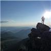
From Pecks's summit, it's an easy, grassy walk to Belford. Picture 1 shows exactly what can be expected. On the way, I encountered a few areas where snow remains, but they're easily by-passed. I made the summit of Belford two and half hours after leaving my car. The next goal was Oxford. There's absolutely no snow on the connecting ridge trail - pristine summer conditions with the wildflowers beginning to appear. I summited Oxford 40 minutes after leaving Belford.
The next peak on my list was Waverly Mountain. It's a lowly 13er 1.2 miles away from Oxford's summit on the east ridge. It was quite apparent there are seldom any visitors to this side of the mountain as there is no trail to follow. My route on the way to Waverly wasn't great. Since there was no trail to follow, I ended up in a mix of talus and scree. It took some time, but I corrected my route and regained the ridge which was much more pleasant. After gaining Waverly's summit, I returned using the ridge route which was much more energy efficient. There are a few places where the talus is unavoidable, but it's very manageable. Waverly is marked (as best I can). Ridge route is best choice to reach it.
After returning from Waverly, I skirted Oxford's summit to the south and headed back down the well maintained trail on the Bel-Ox saddle. I avoided Belford's summit to the south and took the Class 1 trail to Elkhead Pass. Again, there was no snow on the route and allowed for some great downhill trail running. Upon reaching the Elkhead Pass, I descended the south side into the Pine Creek watershed. My goal was to circumvent around the two lakes below the east side of Emerald and Iowa Peaks in order to hit Emerald then work my way north to Missouri Mountain, but there was far too much snow to deal with in trail running shoes for me to feasibly reach the saddle between Iowa and Emerald. I ended up side-hilling on a plethora of tundra, talus, scree, and snow to work my way up to the Iowa-Missouri saddle. Not the most efficient use of time and irritating as all-hell since I hate sidehilling, but it worked. Route Approximation from Emerald Pass to Iowa-Missouri Saddle
The .3 mile hike up Iowa is quick. There's a rough trail to follow to the false summit, but there's still snow impeding the most direct route to the summit from there. As a sat on Iowa's summit, I contemplated my next move with it being a little before 2pm. I considered not going for Emerald but knew I would have kicked myself later for not completing the Grand Slam. With fatigue setting in at this point, Emerald, .8 mile away, appeared further away than I would have liked and the saddle looked like a decent descent (and regain after getting Emerald).
There was an ominous cloud gathering over Emerald when I approached the massif. I waited a few minutes questioning my decision as the 20% of a storm in the forecast seemed to be growing rapidly. I watched the cloud for a few minutes and saw that it was going south; the sky remained relatively clear north of Missouri, so I decided to go for it. Emerald does have a trail up it; it's on the east side and gains the ridge to the summit, but I decided to go for a talus climb to the summit. Putting a little more work on my hands rather than my feet was a relief. Emerald's massif contained no snow. Emerald Peak as seen below Iowa's summit
Finally, I could begin the trek back to the TH via Missouri Mountain. After descending Emerald (and the clouds gathering again), I quickly regained Iowa to the east side of the summit in order to minimize vertical gain and continued to the Missouri-Iowa saddle. From here the trail mostly follows the ridge up to Missouri's summit. The slog up Missouri was snow-free and mainly a class 1 climb. From there I began to descend the ridge following the standard route. There's snow in a few areas on a ridge, but enough people have stamped a path through it that post-holing isn't a major concern. Just be sure to follow the trail down; I made a mistake and began descending a scree gully which was quite unpleasant. The Missouri trail contained snow in a few areas nearing the bottom of the gulch that scream of postholing, but they can be avoided by circumventing it on the surrounding rock. There's areas on the trail where snow cannot be avoided, usually near water drainage. The other important note for the trail above the treeline is the multiple areas it crosses the creek. Currently, the snow-melt has elevated the water levels and many of the rocks used for crossings are submerged. Topographic Map with route outlined
That's all I got. Now it's time to see who is up to the challenge of the Belford Group Grand Slam and beat the time*. Oh, and keeping with the spirit of Roach with the Longs "Radical Slam" where 50 push-ups are required at the end of it, you need to complete 25 burpees for the Belford Slam. And, yes, I did the burpees.
*Dancesatmoonrise and SummitLounger are not allowed to complete. It would just be unfair
Thumbnails for uploaded photos (click to open slideshow):
These types of TR's are usually only written by a select group of elites! Awesome endurance Greg. But this is not encouraging considering that I have to keep up with you in the near future. Eat some donuts and sit on the couch for a week or so. Great write up, my friend.
Every time I'm feeling good about myself, someone posts a trip report like this and suddenly I'm shaken back into the reality that I'm not a real man. Sigh...
Wow. I did the 3 14ers in a single day in January (8500' gain) and it was TOUGH. I can't imagine adding on the other peaks and another 1000' gain. Well done. Well done, indeed!
I just saw this. How did I miss this??!?!. Well done. I like the captions in the pictures. Very helpful man. I'm headed out to BelOxMis next Sunday. Last month, on the summit of Tabaguache, I briefly spoke with a guy who recommended this route. Guess I would need a pretty ridiculous weather window to make this happen now. Again well done! Dan I'll eat some donuts on the summits for you.
Well written account over a worthy endurance adventure! Thanks.
Caution: The information contained in this report may not be accurate and should not be the only resource used in preparation for your climb. Failure to have the necessary experience, physical conditioning, supplies or equipment can result in injury or death. 14ers.com and the author(s) of this report provide no warranties, either express or implied, that the information provided is accurate or reliable. By using the information provided, you agree to indemnify and hold harmless 14ers.com and the report author(s) with respect to any claims and demands against them, including any attorney fees and expenses. Please read the 14ers.com Safety and Disclaimer pages for more information.
Please respect private property: 14ers.com supports the rights of private landowners to determine how and by whom their land will be used. In Colorado, it is your responsibility to determine if land is private and to obtain the appropriate permission before entering the property.


. Ridge route is best choice to reach it.")


 Pecks Peak is marked as seen from Belford. When on the main trail, Pecks is directly to the left after reaching the old cabin")
 Waverly is marked (as best I can). Ridge route is best choice to reach it.")
 Route Approximation from Emerald Pass to Iowa-Missouri Saddle")
 Emerald Peak as seen below Iowa's summit")
 Topographic Map with route outlined")