Download Agreement, Release, and Acknowledgement of Risk:
You (the person requesting this file download) fully understand mountain climbing ("Activity") involves risks and dangers of serious bodily injury, including permanent disability, paralysis, and death ("Risks") and you fully accept and assume all such risks and all responsibility for losses, costs, and damages you incur as a result of your participation in this Activity.
You acknowledge that information in the file you have chosen to download may not be accurate and may contain errors. You agree to assume all risks when using this information and agree to release and discharge 14ers.com, 14ers Inc. and the author(s) of such information (collectively, the "Released Parties").
You hereby discharge the Released Parties from all damages, actions, claims and liabilities of any nature, specifically including, but not limited to, damages, actions, claims and liabilities arising from or related to the negligence of the Released Parties. You further agree to indemnify, hold harmless and defend 14ers.com, 14ers Inc. and each of the other Released Parties from and against any loss, damage, liability and expense, including costs and attorney fees, incurred by 14ers.com, 14ers Inc. or any of the other Released Parties as a result of you using information provided on the 14ers.com or 14ers Inc. websites.
You have read this agreement, fully understand its terms and intend it to be a complete and unconditional release of all liability to the greatest extent allowed by law and agree that if any portion of this agreement is held to be invalid the balance, notwithstanding, shall continue in full force and effect.
By clicking "OK" you agree to these terms. If you DO NOT agree, click "Cancel"...
Date: May 20, 2012
Group: Ryan (Monster5), Ryan (Monterado), Chris and Natalie (nkan02)
RT time: ~11 hours camp to camp by the Crater lake.
We all agreed to meet by the Crater Lake campgrounds, but conveniently ran into each other at the Maroon Lake parking lot. Upon reading a very timely update (thank you, unclegar) about another porcupine assault earlier in the week, both Monster Ryan and I came prepared. However, the chicken fences that we brought only covered about half the perimeter of the car, so we parked our cars next to each other, connected the wires and tried to cover the full perimeter. Alas, even so, the front area of each car remained unprotected. Unwilling to leave it at the mercy of the hungry porcupines, we collected some rocks and erected a barricade, then generously sprinkled it with mothballs. A good pour of ammonia went around the perimeter of the fence. This engineering feat delayed our departure time to the Crater lake by over an hour. As we were leaving, Ryan's main concern was to find a family of porcupines trapped under the cars and unable to figure out how to escape. I concluded that he likely spent too much time reading the "Cows in Conundrum Hot Springs" thread.
Porcupine-proof
We reached our campsites #10-11 just before 7pm, promptly set up camp and hit the sack shortly after 8pm. I was conveniently tired from skiing some runs at the Independence Pass earlier that day and slept rather well. We were up by 2.30 am and moving at 3.15am. We saw several headlamps that passed our camp as we were ready to leave, but a couple of them were headed towards Thunder Pyramid. We could see one lone headlamp ahead of us. The hike in the dark up the apron was rather uneventful.
Ryan
It was a little slow going for me, and I was cursing my slightly tired legs from skiing the previous day and inability to swallow any food at such an early hour. Still, I was fairly confident that eventually I would wake up. We caught up with the lone hiker in about an hour and went as a group for a while. But first, we had to find the entrance to the couloir, which was not very easy in the dark. Monster Ryan had the right instinct to go left, but got deterred by bushes and rocks in the Garbage Chute area. We reluctantly went right on rather steep snow. Luckily for us, the dawn was breaking, and we finally could see where we were headed. The sunrise caught us at 11,600 ft, or just at the bottom of the couloir "proper". With stops for route finding and sunrise pictures, I had a chance to swallow some food and energy stuff and was finally ready for the climb.
The next 2,000 feet were nothing short of spectacular. From what it looked like, the Bells got some snow the day before (which was rapidly melting under the morning sun), but aside from a few localized areas, the snow was well consolidated and provided good purchase for crampons. Both Ryans kept switching leads and making steps and I tried to stay not too far behind.
Localized wetslide
Two skiers can be spotted way down below
At some point, I looked down to see how two others were doing and noticed a couple of skiers at the very bottom of the climb - mind it, it was probably around 5.30am. Remembering this TR and the fact that I was near Aspen, I decided to withhold my judgment, and I am sure glad I did!
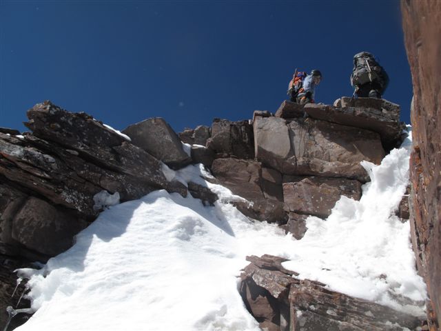
Ryans are topping out
When I looked down next time from probably around 13K, the skiers were already approaching 12K. Both Ryans topped out a quarter to 8am, me shortly thereafter. As we looked down the couloirs to see how far the rest of our group was, we saw ascending skiers. It turns out they started from the Maroon Lake parking lot at 4.30am. Even more impressive, they carried 120mm skis with telemark bindings and planned to ski the Southeastern (Y) couloir.
At the saddle
A group of us enjoyed a well deserved break, contemplating our options and the route ahead. Chris joined us at about 8.30am with the news that the fifth person had turned around. One look at the western (shaded) side of the Maroon Peak revealed that gaining the remaining 400 feet to the summit would not be an easy task.
The following discussion ensued:
- How do we get down this?
- We have a rope, we could rappel.
- Will it be long enough?
- We have two ropes.
- Ummm, okay.
How do we get down this?
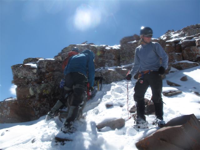
I made a mistake of switching from crampons to microspikes on the top of the couloir as I assumed that it would be enough to navigate the rocks and snow covered ledges. Wrong! After a few moves on the rocks, I had to traverse a little bit of snow to the next group of rocks and quickly discovered that microspikes are not doing anything for traction. I retreated, perched myself on a slanting ledge and quickly put crampons back, while Monster Ryan was keeping my backpack from sliding a couple of thousand feet down the mountain. The four of us pushed on, trying to find any indication of the route, well hidden under the snow.
Easier with crampons
From time to time, the Ryans would spot a random cairn. A few rather "interesting" cruxes followed. I forbade myself to look at the GPS - I knew we were close, but the summit could be as far as the other side of the pass. Finally, both Ryans climbed the last obstacle, and the snow covered summit was within sight.
Some of the typical moves
>
Final obstacle
Then an unusual thing happened - Ryans told me to go ahead. I responded that I did not deserve the honor since I was mostly following them, but they insisted: "ladies first". And here I was, strolling into the pristine, snow-covered peak of South Maroon, adorned by a large cornice. What a treat! The recent snowfall covered all the previous tracks and it looked as if nobody had been on the summit for a while (probably just a few days). This was definitely one of the highlights of the trip for me and I appreciated the honor very much.
> Pristine summit
Snowmass-Capitol
North Maroon
The rest of the group and both skiers joined me on the summit and we took a quick break, admiring the sweeping views. It was already 10am, however, and it was time to decide on the descent route. Given the difficulty in gaining just 400 feet up the Western face of the peak, we were concerned that the traverse to North Maroon would take an inordinate amount of time. The skiers were heading down to ski the Southeastern (Y) couloir, and we briefly considered following them, but decided to head back the way we came.
The descent back to the couloir was "interesting". The cruxes that were a challenge coming up were even bigger challenge coming down. The descent route through initial ledges was on everybody's mind. Both Ryans were eager to put the ropes they were carrying all day to use. The trick was to find a large and stable rock - a tall order in the Elks. However, the Ryans were able to find just the right rock and even additional ledge to put protection in.
Setting up the rappel
me on the rappel
Monster5/Ryan on the rappel
We spent the next hour rappelling down into the notch of the couloir, which was pretty exciting. As I was landing on the ledges, I appreciated that we did not have to descend them - they were slanted, not very stationary, and rather slippery with snow and ice on them. Whew! We are back at Bell Cord and it is already 12pm.
back at the notch
Monster Ryan, who was rappelling last, told the two slowpokes - myself and Chris - to start descending to save time, while the Ryans are packing up the ropes. I obliged, and quickly dropped into the couloir. Fifty feet down, and I don't hear any movement, hundred feet, nothing. I decide to stop and inquire about what's going on. It turns out the rope got stuck on some of the ledges and one of the Ryans went up to retrieve it. Darn, I missed the commotion. Although I did not appreciate sitting in the couloir waiting for the situation to resolve for the next 30 minutes, nothing happened. The snow was getting soft, but the boot penetration (bootpen test) was about to an ankle - not too bad, considering how late in the day it was getting. Finally, with the ropes retrieved and packed, three heads were poking over the lip of the couloir:
- How is it?
- It's fine.
- (Rather incredulously) It's fine?
- It's fine. Get over here.
Back in the couloir
Pyramid & friends
The next hour was spent rather frantically, trying to descend 1,500 feet as quickly as possible. I decided early on, that the style points can go to h*ll, and I would be downclimbing facing in - this way I could get 3 points of contact with the snow, and would be in the self-arrest position should there ever be a need for self arrest. It was a surprisingly efficient way to travel. Not a single rock fell while we were descending. Somewhere around 12,500ft, I stood up and discovered that I can walk down the mountain. But why walk, especially since the knees were asking for a break? With angle no higher than 25 degrees, I was able to glissade a few hundred feet to meet Monster Ryan who was chilling out in a safe spot. Then we waited for the other Ryan and Chris, who had trouble with crampons, as his strap-ons kept coming off on the descent. We could also see the ski tracks on the SE/Y couloir. We wondered if the skiers were already eating lunch at their Aspen home. The area through the Garbage Chute was much easier to navigate at daylight, and after a few more glissades down the apron we stumbled back into the camp at 2.30pm.
We quickly packed up the camp, made a few obligatory shots of the Bells on the hike out and reached the cars at about 4pm to find our car barricade untouched and no porcupines in sight. Overall, a great day in the Elks. Nice climbing with you guys.
Nice report, Natalie! It was nice climbing with you guys.
~1” Webbing (other Ryan's - I'll reward a clean up with beverage of choice)around a convenient block. Backed the first few raps up with a #2 in a cliffband 20' away. A single 30m would at least get somebody down to manageable terrain.
Once the fresh stuff melts (likely by now), no rap is warranted. We did not use a rap ring and our knot also caught in a notch. Lesson learned.
My hands were sweating just reading the logs. Our plan is to climb this on 8 June, hoping the Cord will be in good shape, but the last 300 feet will be snow free. Vort.
Thanks for writing, great pictures and info. Looks like a really amazing trip. Ryan/Monster - were you guys able to set up the rap with just some webbing/cord?? Thx.
Saxlover - I thought it might be you, but was not sure (no time for a chat trying to keep up with the Ryans! . It was nice meeting you, although briefly.
Wyoming Bob - Congratulations on the ”Thunder”. You are correct, route finding in the dark was not easy. We ended up going to the right of the Garbage Chute on the steepest snow of the day ~50 degrees. Good practice I guess.
Abe - you bet.
Gueza - We saw the skiers walk on the snow off the summit, I guess they were not after style points either. They said they skied the peak several times before. My understanding is that some ridge walking/downclimbing is involved to get down to SE/Y and they said it would be easy. But I wouldn't trust them on that 8)
unclegar - thank you again for the timely beta. Much appreciated!
mattpayne11 - not for the first time. We did Ice Mtn together last year.
Egogo, dmmcool, chinook, d_baker, AlexMack, John_Young, Dillon, Michael/Boggy B, Vorticity - thank you very much
Caution: The information contained in this report may not be accurate and should not be the only resource used in preparation for your climb. Failure to have the necessary experience, physical conditioning, supplies or equipment can result in injury or death. 14ers.com and the author(s) of this report provide no warranties, either express or implied, that the information provided is accurate or reliable. By using the information provided, you agree to indemnify and hold harmless 14ers.com and the report author(s) with respect to any claims and demands against them, including any attorney fees and expenses. Please read the 14ers.com Safety and Disclaimer pages for more information.
Please respect private property: 14ers.com supports the rights of private landowners to determine how and by whom their land will be used. In Colorado, it is your responsibility to determine if land is private and to obtain the appropriate permission before entering the property.


 >
>
 >
>


 Ryan")
 me on the rappel")
 back at the notch")


