Download Agreement, Release, and Acknowledgement of Risk:
You (the person requesting this file download) fully understand mountain climbing ("Activity") involves risks and dangers of serious bodily injury, including permanent disability, paralysis, and death ("Risks") and you fully accept and assume all such risks and all responsibility for losses, costs, and damages you incur as a result of your participation in this Activity.
You acknowledge that information in the file you have chosen to download may not be accurate and may contain errors. You agree to assume all risks when using this information and agree to release and discharge 14ers.com, 14ers Inc. and the author(s) of such information (collectively, the "Released Parties").
You hereby discharge the Released Parties from all damages, actions, claims and liabilities of any nature, specifically including, but not limited to, damages, actions, claims and liabilities arising from or related to the negligence of the Released Parties. You further agree to indemnify, hold harmless and defend 14ers.com, 14ers Inc. and each of the other Released Parties from and against any loss, damage, liability and expense, including costs and attorney fees, incurred by 14ers.com, 14ers Inc. or any of the other Released Parties as a result of you using information provided on the 14ers.com or 14ers Inc. websites.
You have read this agreement, fully understand its terms and intend it to be a complete and unconditional release of all liability to the greatest extent allowed by law and agree that if any portion of this agreement is held to be invalid the balance, notwithstanding, shall continue in full force and effect.
By clicking "OK" you agree to these terms. If you DO NOT agree, click "Cancel"...
MOUNTAIN: Little Bear Peak (14,037') ROUTE: Hourglass, with modified descent of Southwest Ridge DEPART LAKE COMO: 4 a.m. LITTLE BEAR SUMMIT: 9 a.m. RETURN LAKE COMO: 6 p.m. CLIMBERS: Ryan (kushrocks), Dan (dmccool), Rob (RJansen77), Greg (gregory_fischer), Ben (BenfromtheEast), Jeff (SurfNTurf)
I punched out for the last time, threw a cardboard box of cubicle goodies in my trunk and turned my thoughts to Little Bear. I was staring a major life decision in the face, something that should have scared me. I was saying goodbye to a field in which I'd made my career since college. Was I making the right choice? Ben, Ryan and Rob arrived before my mind could go all existential. It took a bit of Jetta Tetris, but somehow we were able to fit four overnight packs into Ben's sedan and off we raced down I-25 bound for the Lake Como Road. We were swelling with optimism and excited for an adventure unlike any other, but a nagging question loomed in the back of all our minds:
Would it go?
The Hourglass, research suggests, comes into snow-climbing condition between late April and May in a typical year. This is not a typical year. Dan, who needed all three peaks in the Lake Como group, suggested giving it a go the last weekend of March. I was dismissive at first, wanting to hear first-hand beta before heading up that damned road chasing a pipe dream. But one by one my other plans fell through, and Dan was able to convince me to join him on Operation Guinea Pig.
The group, initially small, swelled to six - Ben (BenfromtheEast), Ryan (kushrocks), Dan (dmccool), Jeff (SurfNTurf), Greg (gregory_fischer) and Rob (RJansen77). A bit large for the Hourglass, we all admitted"but we were all friends and trusted partners, so who could tell who not to come?
We met Dan and Greg at the base of the Lake Como Road. We took a long while to study the Hourglass from afar. It looks filled, right? See that right branch? As long as we can get above the choke, we should be golden. Yeah. Yeah. Let's do this. We piled into Dan's truck, brimming with excitement, and parked at 8,800'. We hadn't been able to leave Denver until nearly 2 p.m. and the second half of our approach would be in the dark.
That meant two things: a miserable time setting up camp, and a spectacular San Luis Valley sunset.
Rob, Ben, me, Dan and Greg hiking up the Lake Como Road, with a view.
We filled our water bottles and made dinner as fast as we could, but we still didn't turn in until nearly midnight. With alarms set for 3 a.m. and nervous excitement boiling in our stomachs, nobody managed much sleep. Dan and I actually woke up at about 2 a.m. and couldn't sit still. I drove the rest from their slumber by blasting pump-up music: Bon Jovi, Audioslave, Justin Bieber, the Gorillaz. Game on.
We left camp at 4 a.m. We couldn't see it, but we stumbled our way to the base of the West Ridge entrance gully. It was awful. The north-facing couloir was filled with snow that was about as supportive as a stripper's father. It took us much longer than anticipated to slog our way to the West Ridge proper, where we were greeted by the lights of Alamosa and the first rays of sun to the east.
(taken later) The gully leading from Lake Como to Little Bear's West Ridge.
Me and Ben topping out on the gully well before dawn.
We picked our way along the ridge, staying mostly low and to the right following either cairns or random piles of misleading loose rock. The line didn't much matter. Our goal was now in sight. We turned the headlamps off about the time we reached the first snowfield. Crampons went on, axes off the packs. Rob was the first to reach the base of the dreaded Hourglass at 7:15 a.m. When we yelled to ask what it looked like, he shrugged. It looks like a little bit of everything, he said.
Rob traversing across to the base of the Hourglass.
Little Bear's mountain shadow over the San Luis Valley.
The apron, at least, was decent snow. We cramponed up to the first safe zone, seeming to have our dreams realized. Would it go? It's going to go.
Rob and Ryan were the first pair up the next section. "Ice," they muttered, and kept going. The steady "thwock thwock" of Ryan's ice ax rang through the morning silence. Greg, Dan, Ben and I looked at each other, and followed.
First group starting up the Hourglass on decent snow.
Ryan, a little excited to be there.
The first section of ice was easy. The ax picks snagged good purchase and there were abundant rock holds for extra peace of mind. We made quick, comfortable work up and past the base of the fixed rope. Conditions changed intermittently from firm snow to nice malleable ice. The higher we climbed, the more difficult and unavoidable the ice became.
Finally, the question.
Should we keep going?
Decision time. We were prepared for this scenario. Ice meant two things: we either turn around and call it a day, or we keep on to the summit and descend a different route. A quick poll led to a unanimous decision. Let's push on. Each climber was comfortable in his ability to ascend what was in front of him, and we knew from our studies that the Southwest Ridge had several bailout options to reach Little Bear Lake, and thus our return notch over the West Ridge to Lake Como. It wasn't ideal - we'd much rather descend the Hourglass and be back at camp for brunch - but it was the safest plan that included a Little Bear summit.
So much for a straightforward snow climb.
Me, followed by Ben, hacking our way up the Hourglass.
Dan and I coming through the choke point.
Hourglass.
We finally reached a section of ice that daunted us. Ryan, route-finding genius that he is, found a single Class 5 move onto rock that led to easier terrain. The move got the adrenaline pumping, especially in crampons, but before long all six of us were on Class 3 and 4 rock with a clear path to the summit.
Off the snow and ice, the final rock pitch to the summit.
"Rock!"
"Rock!"
"Rock!"
The Hourglass lives up to its reputation. I'm just glad no one was below us. Even being cautious, ascending in close-knit teams from safe zone to safe zone, Ben and I caught rocks on the helmet. Upward we slogged, inching close and closer to the most difficult of 14er summits. Finally. The ridge. Solid rock. Exposure. A turn left, a few hundred feed of scrambling, and nowhere else to go. Welcome to the summit of 14,037' Little Bear Peak.
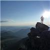
Rob revels in the final ridge run to Little Bear.
Rob and Ryan cheer on the rest of us.
Group shot on the summit. It was a privilege to climb with these guys.
Ellingwood, Blanca, Lindsey.
We hugged. We high-fived. We took pictures. There's not a feeling in the world better than that, finally achieving a goal that had scared you since you first heard the word "14er." Reality didn't escape us, though. We were only halfway there. Not even halfway. One by one, we gazed across the Mama Bear Traverse to South Little Bear and down the neverending Southwest Ridge. My prevailing thought: we should have brought more water.
The Mama Bear Traverse to South Little Bear.
The Mama Bear was dry, solid, and exposed. The route-finding was a bit of an adventure, but again Ryan faithfully led the way. The hardest part was regaining the ridge proper after dropping down a bit from the Little Bear summit. Once back on the true traverse, the line was fairly obvious. The way down, however, wasn't.
Rob regaining the ridge crest on the traverse.
"Which way down?"
Group on the Mama Bear.
Ryan, again, is the first to reach the top.
Looking back toward Little Bear, from South Little Bear.
The gullies that had looked so good on topo maps and from the Little Bear summit got steeper with every step. It wasn't time to panic"worst-case scenario, we'd go all the way down the Southwest Ridge past Little Bear Lake, descend the easy talus slopes right before treeline and regain a ton of elevation back to our notch on the West Ridge. But it was time for reality to set in. This was going to be a long day.
South Little Bear was nearly as spectacular as its taller cousin. The traverse was definitely worth the time, but we were now focused on getting down. We took a long hard look at our bailout options from the Southwest Ridge, delayered, and set off. No use complaining. We had to get back to camp, and it was going to suck.
Easier ground never came. We'd been scrambling for hours upon hours now without a break, and an easy Class 2 walk sounded enticing. The upper part of the Southwest Ridge route, however, is about the antithesis of "enticing." It's loose, exposed, hot and miserable.
The first and second potential bailout gullies were dismissed with little more than a tentative glance. The third and fourth were explored and deemed impossible. Farther and farther down the ridge we went, with each of us slowly resigning ourselves to a descent to treeline.
Ben peering down the abyss.
Keep on keepin' on...
Me and Greg, ready for a drink.
Dan trying to find a way down, with the day's work in the background.
Finally, we reached the last possible gully before the final ridge point above treeline. If it went, it would save hundreds of feet of elevation gain. It looked good. We started down. It was loose and steep, but it seemingly offered a direct descent to the drainage. It took a bit of maneuvering and route-finding, and infinite screams of "ROCK," but sure enough we found our way to Tobin Creek. For the record, I wouldn't recommend this route. It would have been safer and arguably just as quick to continue down to the easier slopes below the last ridge point and come back up past Little Bear Lake.
Descent gully (not recommended!).
After a quick break we stared up at our final obstacle: a 500-foot gully of loose talus and scree back to the top of the West Ridge. From there, we'd have an easy glissade back to Lake Como. But "there" seemed as far away as the moon. One step in front of the other. Getting closer. Almost there. Finally! We'd obtained our glorious notch, which was our gateway back to the food and celebratory drinks awaiting at Lake Como.
One blissful glissade later, we reached the place we'd stashed our snowshoes what seemed like an eternity ago. Of course, Little Bear wouldn't let us go that easily. The snowshoe down from 11,900' to 11,750' was a posthole nightmare, one more slap in the face to end an already tedious day.
The glissade back to Lake Como, 14 hours later.
Only when we reached camp and dropped our packs did it hit us. We'd done it. All six of us had summited Little Bear and had nary a scratch to show for it. It had taken 14 hours. But we'd done it.
Rob relaxes the next morning at Lake Como, soaking in the accomplishment.
Rough map of our route (by Rob).
So yeah. Compared to the weekend, the first day at my new job today was a breeze. Dan, Greg, Ryan and Ben went on to summit both Blanca and Ellingwood the next day, while Rob and I relaxed in the sun at camp. Little Bear is a mountain that commands your best, and I can't thank my five partners enough. I wouldn't have gone up there with anyone else.
Thumbnails for uploaded photos (click to open slideshow):
...about as supportive as a stripper's father 4/3/2012 3:39am
That pretty much sums up the entire mountain. This was such a humbling experience for me. The obvious reason being that the mountain was so formidable. But being around such a fantastic group of men and getting to experience all the physical, emotional, and mental ups and downs together will keep this climb alive for the ages. Well done my friends.
Way to persevere and get it done, guys! So glad you all stayed safe and it sounds like the ultimate team mentality made for a successful day. Great trip report as usual, Jeff, keep up the good work
I'll remember this one for a while... 4/3/2012 1:22pm
I don't think I've ever been part of a more focused and well-functioning team. It was a privilege to share the climb with these guys; everyone brought something to the table and we were able to depend on each other throughout the trip. I know I won't be forgetting this one for a while. Hope to see you all out in the hills again soon.
You know the old saying, when life hands you tequila, make margaritas ... or something like that. You made the best of the hand you were dealt and came away winning! Congrats to all. Thanks for posting ... great report. Happy trails!
Great job everyone and nice write up. Very impressive route finding. It is, well, committing to choose a different descent route on a tough mountain.
IMHO route finding and making calculated decisions is so much more important than most other skills one needs in the mountains. Its awesome to see people doing it right!
”It was quite the leisurely day. I almost felt like I was cheating.” HAHA - No seriously though that day was really long and exhausting but so worth it.
If I think of a functioning team on a mountain that is exactly what we had. We all worked together getting each other through the tough parts and were very conscious of how everyone else was doing. It was an honor and a privilege to climb with you guys. I am really looking forward to next time.
I probably would have done something similar with the mixed climbing conditions in the hourglass. It looks like conditions were about the same as they were over Memorial Day last year. Fortunately, the group I was with had ropes and gear, so we just rapped through the constriction on the hourglass. Congrats!
That was one hell of a trip to start the Spring season. Mentally, I still don't know how to come to terms with what we accomplished. Crazy, dangerous, and death-defying all seem like appropriate terms. But, man, was it AWESOME! I know that thought never occurred to me on the ”route,” but a few days of perspective has me pumped.
Jeff, I need to take offense to one thing: ”I can't thank my five partners enough. I wouldn't have gone up there with anyone else.” Really? Not one??? Remember, WWID.
~Greg
Caution: The information contained in this report may not be accurate and should not be the only resource used in preparation for your climb. Failure to have the necessary experience, physical conditioning, supplies or equipment can result in injury or death. 14ers.com and the author(s) of this report provide no warranties, either express or implied, that the information provided is accurate or reliable. By using the information provided, you agree to indemnify and hold harmless 14ers.com and the report author(s) with respect to any claims and demands against them, including any attorney fees and expenses. Please read the 14ers.com Safety and Disclaimer pages for more information.
Please respect private property: 14ers.com supports the rights of private landowners to determine how and by whom their land will be used. In Colorado, it is your responsibility to determine if land is private and to obtain the appropriate permission before entering the property.


 The gully leading from Lake Como to Little Bear's West Ridge.")


.")


.")
 Rob, Ben, me, Dan and Greg hiking up the Lake Como Road, with a view.")
 (taken later) The gully leading from Lake Como to Little Bear's West Ridge.")
 Me and Ben topping out on the gully well before dawn.")
 Rob traversing across to the base of the Hourglass.")
 Little Bear's mountain shadow over the San Luis Valley.")
 First group starting up the Hourglass on decent snow.")
 Ryan, a little excited to be there.")
 So much for a straightforward snow climb.")
 Me, followed by Ben, hacking our way up the Hourglass.")
 Dan and I coming through the choke point.")
 Off the snow and ice, the final rock pitch to the summit.")
 Rob revels in the final ridge run to Little Bear.")
 Rob and Ryan cheer on the rest of us.")
 Hourglass.")
 Group shot on the summit. It was a privilege to climb with these guys.")
 Ellingwood, Blanca, Lindsey.")
 The Mama Bear Traverse to South Little Bear.")
 Rob regaining the ridge crest on the traverse.")
 \"Which way down?\"")
 Group on the Mama Bear.")
 Ryan, again, is the first to reach the top.")
 Looking back toward Little Bear, from South Little Bear.")
 Ben peering down the abyss.")
 Keep on keepin' on...")
 Me and Greg, ready for a drink.")
 Dan trying to find a way down, with the day's work in the background.")
 Descent gully (not recommended!).")
 The glissade back to Lake Como, 14 hours later.")
 Rob relaxes the next morning at Lake Como, soaking in the accomplishment.")
 Rough map of our route (by Rob).")