Download Agreement, Release, and Acknowledgement of Risk:
You (the person requesting this file download) fully understand mountain climbing ("Activity") involves risks and dangers of serious bodily injury, including permanent disability, paralysis, and death ("Risks") and you fully accept and assume all such risks and all responsibility for losses, costs, and damages you incur as a result of your participation in this Activity.
You acknowledge that information in the file you have chosen to download may not be accurate and may contain errors. You agree to assume all risks when using this information and agree to release and discharge 14ers.com, 14ers Inc. and the author(s) of such information (collectively, the "Released Parties").
You hereby discharge the Released Parties from all damages, actions, claims and liabilities of any nature, specifically including, but not limited to, damages, actions, claims and liabilities arising from or related to the negligence of the Released Parties. You further agree to indemnify, hold harmless and defend 14ers.com, 14ers Inc. and each of the other Released Parties from and against any loss, damage, liability and expense, including costs and attorney fees, incurred by 14ers.com, 14ers Inc. or any of the other Released Parties as a result of you using information provided on the 14ers.com or 14ers Inc. websites.
You have read this agreement, fully understand its terms and intend it to be a complete and unconditional release of all liability to the greatest extent allowed by law and agree that if any portion of this agreement is held to be invalid the balance, notwithstanding, shall continue in full force and effect.
By clicking "OK" you agree to these terms. If you DO NOT agree, click "Cancel"...
Mountains: Cupid, Grizzly, Torreys Route: Westridge from Loveland Pass, to and fro Who: Myself
Forecast was excellent. Left my bed in Denver a quarter to 5:00 and enjoyed the full moon and NPR on the nice drive up the hill, just me and a lot of tractor trailers.
Top of Loveland Pass/Trail head, Full Moon just past 6:00
I had been scoping this route (West Ridge from Loveland pass, Continental Divider Roller Coaster) for a real long time and continually checking weather for the right time to try it. Well for those who were out.. this past weekend turned out to be awesome blue bird days with no wind.
The Starting Line Full Moon and Sunrise over Loveland/Continental Divide
Cupid W/ Torreys and the goal towering above!
After riding at A-basin last week and getting a good look at the snow and ridge lines above, I felt no need to bring flotation and very much did not regret that decision. I was walking along dirt/grass trail and rock 80% of the time.
Wind Waves A top Cupid with Grizzly, Torreys, Grays in view Fun section between Cupid and Grizzly Looking back
Arapahoe Basin back there!! Keystone, Breck, Tenmile and Gore Ranges. Grizzly Gulch On Top Grizzly looing south towards Lenawee and East Wall of the Basin
Looking at the Ridge that continues south towards Lenawee!! looks like a lot of fun, I think I may start at Loveland pass trailhead another day and go for that ridge and hike into Abasin and maybe bring my season pass along and decend Lenawee down into A-basin and hitch a ride back up the Pass to my car!
Does anyone have any info or advice on this ridge/route, East wall?? maybe class 3/4? it did look more aggressive, any info? Thanks
Looking Back at progress Lonnnnng way to go!
Fun section decending Grizzly
I threw on my microspikes on the decent of Grizzly, the top section was the most technical of the route with most exposure, glad I had some traction and poles. About midway down I traversed across some snow fields, tried to stay with some rock bands, post holed very little and didnt suspect any Avy Danger but I am no expert!!
Huge saddle, looking back up Grizzly
Strenuous Talus Field, Choose your route Rear view Mirror Dig in VERY TIRED! cant quite
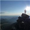
Torreys' Big Sis Summit
I finally summited at half till noon, took me almost six hours. I took a nice break, ate the rest of my food. Nearly right as I sat down my phone rang... haha it was my mom, just checking up on me.. she had no idea I was hiking, we had a nice long talk, she told to be safe and stop going solo.. I have verizon service, worked great. Shortly after I noticed some movement and the silhouttes of some friendlies on the switch backs heading up Grays. It was amazing I could hear their voices and just nearly make out the words in the silence of the summit.
Kelso Stevens Gulch, Mcclelland, Edwards and ANNA's sweet route!!!! Bierstadt, the Sawtooth and Evans A bit of butt tubbing on the decent of Torreys Divided
Holy crap I was tired going back up Grizzly and Cupid and up and down and up and down the remaining miles of the mellow trail leading back to my car. I made it back to the trailhead at 16:00 and chated a bit with some tourists from Chicago wondering where I was coming from. Total round trip was 10 hours. I really loved the route but not sure I would do this one agian
Thumbnails for uploaded photos (click to open slideshow):
I've never done this route, but have wondered about it's feasibility with the low snow year we've had. Looks like you caught a great day, I really like the shot with the moon over the divide. Congrats!
Nice work! Grizzly twice on one sitting is no joke. A few weeks after the Basin shut down last season I made the trek from the pass onto Lenawee Ridge. Once you start across Black Mountain route finding can be difficult. The time it took me to traverse it was equal to if not more than crossing Cupid and Grizz. Obviously there is no skiing on the East Wall this season. Hopefully next winter will give us that oppertunity. My advice for when that chance comes... save your legs and stick to the lifts.
Going tomorrow and cant wait. Thanks for posting you're pictures. I have attempted so many summit's this year and have had plenty of failed attempts, but that's just part of the fun.
Stay on the mountain side!
Caution: The information contained in this report may not be accurate and should not be the only resource used in preparation for your climb. Failure to have the necessary experience, physical conditioning, supplies or equipment can result in injury or death. 14ers.com and the author(s) of this report provide no warranties, either express or implied, that the information provided is accurate or reliable. By using the information provided, you agree to indemnify and hold harmless 14ers.com and the report author(s) with respect to any claims and demands against them, including any attorney fees and expenses. Please read the 14ers.com Safety and Disclaimer pages for more information.
Please respect private property: 14ers.com supports the rights of private landowners to determine how and by whom their land will be used. In Colorado, it is your responsibility to determine if land is private and to obtain the appropriate permission before entering the property.


 Top of Loveland Pass/Trail head, Full Moon just past 6:00")
 The Starting Line")
 Full Moon and Sunrise over Loveland/Continental Divide")
 Cupid W/ Torreys and the goal towering above!")
")
 Wind Waves")
 A top Cupid with Grizzly, Torreys, Grays in view")
 Fun section between Cupid and Grizzly")
 Looking back")
 Arapahoe Basin back there!! Keystone, Breck, Tenmile and Gore Ranges.")
 Grizzly Gulch")
 On Top Grizzly looing south towards Lenawee and East Wall of the Basin")
 Looking Back at progress")
 Lonnnnng way to go!")
 Fun section decending Grizzly")
")
 Huge saddle, looking back up Grizzly")
 Strenuous")
 Talus Field, Choose your route")
 Rear view Mirror")
 Dig in VERY TIRED! cant quite")
 Torreys' Big Sis")
 Summit")
 Kelso")
 Stevens Gulch, Mcclelland, Edwards and ANNA's sweet route!!!!")
 Bierstadt, the Sawtooth and Evans")
 A bit of butt tubbing on the decent of Torreys")
 Divided")