Download Agreement, Release, and Acknowledgement of Risk:
You (the person requesting this file download) fully understand mountain climbing ("Activity") involves risks and dangers of serious bodily injury, including permanent disability, paralysis, and death ("Risks") and you fully accept and assume all such risks and all responsibility for losses, costs, and damages you incur as a result of your participation in this Activity.
You acknowledge that information in the file you have chosen to download may not be accurate and may contain errors. You agree to assume all risks when using this information and agree to release and discharge 14ers.com, 14ers Inc. and the author(s) of such information (collectively, the "Released Parties").
You hereby discharge the Released Parties from all damages, actions, claims and liabilities of any nature, specifically including, but not limited to, damages, actions, claims and liabilities arising from or related to the negligence of the Released Parties. You further agree to indemnify, hold harmless and defend 14ers.com, 14ers Inc. and each of the other Released Parties from and against any loss, damage, liability and expense, including costs and attorney fees, incurred by 14ers.com, 14ers Inc. or any of the other Released Parties as a result of you using information provided on the 14ers.com or 14ers Inc. websites.
You have read this agreement, fully understand its terms and intend it to be a complete and unconditional release of all liability to the greatest extent allowed by law and agree that if any portion of this agreement is held to be invalid the balance, notwithstanding, shall continue in full force and effect.
By clicking "OK" you agree to these terms. If you DO NOT agree, click "Cancel"...
Route: Up - variation of Southwest Ridge from Fourmile Creek, Down - South slope (snow route) Date: January 7, 2012 RT Distance: Over 10 miles
Elevation Gain: approximately 3,100 feet (started a mile below the Leavick site) Time: under 7 hours with lots of stops for pictures as I took 277 photos (which actually comes down to 0.7 pictures per minute) Who: Lynn (LynnKH) and Natalie (nkan02), as part of the larger group with DoubelDD, awilbur77 and others.
Prologue:
I check the Sherman weather the first thing in the morning on Friday and immediately text Lynn to say that I am out. Although the Sherman forecast is not totally out-of-question - it calls for high of 22 F, wind gusts under 30 mph and mostly overcast skies, the forecasts for nearby peaks are much worse - 70% to 80% chance of precipitation after 11 am. "There is no point of doing this", I tell Lynn. She convinces me to hold off until Friday afternoon to make the final call. In the meantime, she points out that is we were to start at 6 am, we should theoretically make it back to the road by 11 am or so, - which would be an acceptable level of risk in case of a white-out. By Friday afternoon I am reluctantly willing to give it a try. We are meticulously checking the weather nearly every hour to see if the forecast has changed. It has not. By Friday night, more people have bailed out from the hike due to the weather and I get a surprise call from Lynn - she is also thinking of bailing out. I call her back and we decide that the trip is still a go, even if we only walk to the gate past the Leavick site. We set alarms for 3am and arrange to meet in Denver at 4am, with very low expectations for a successful summit day.
Not an auspicious beginning
Things go generally according to plan until we are approaching the Fourmile creek TH at 6am. Light snow is already coming down. Our hearts sink. I am certain that the thought of turning around then and there has occurred to both of us, but it was not voiced. At the same time we see a car driving in our direction, and we think there is someone else deciding to turn around. It is DoubelDD and he is just re-parking, as the road is getting markedly worse further on. We gather the hike is still on. Another car arrives. We gear up and hit the road by 6.25am.
Early morning cloud action
We split up very early on into small groups, as everyone has different goals for the day and various hiking speeds. We are not feeling our best and are just chugging along the road. To our surprise, weather conditions are gradually starting to improve. Out of the blue, we are treated to a spectacular sunrise. Our spirits lift up. We continue to marvel at the beautiful area around us.
Sunrise
Blue skies ahead?
Maybe not.
Get ready to run
The last time I hiked Sherman in August'10, I was distracted by crowds of fellow climbers and the abject dilapidation of the mining ruins. Back then, I was in a mood for some solitude and in search of "raw nature". Artifacts of human activity such as mining ruins were unwelcome reminder of the civilization that was never too far away. This time it was different. We were alone, save for a few hikers appearing and disappearing on the horizon, and the ruins looked unique against the backdrop of a stormy sky.
Mining ruins #1
Mining ruins #2
Mining ruins #3 (high ruins)
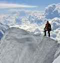
We got to the "highest" ruins just before 9 am and evaluated our options for the summit bid. We saw some hikers to the right of us, working the talus. We saw another hiker (awilbur77) directly ascending the Sherman-Sheridan saddle. Although the saddle route looked cool, we were spurned by the view of expansive (albeit thin) cornice adorning the ridge.
Going up the Sherman-Sheridan saddle
cornice detail
DoubelDD was also ascending the headwall as a snow climb, but it looked like he was mostly avoiding the cornices and was moving in the general direction of the Sherman summit. We decided to follow his path. Who knew that Sherman would be a cool snow climb? We got out our ice axes and got some practice ascending a 30 degree nearly bullet-proof snow slope with microspikes. I stopped a lot to take pictures, so by the time we reached 13,000 feet, we could see the weather was fast moving in. The proper Sherman summit was still about an hour away. We sped up.
Clouds lift up momentarily
Alas, not for long. The storm is coming
Looking back at Sheridan
Iowa Gulch
The weather has been very mild until approximately 500 vertical feet from the summit, when the winds suddenly picked up and temperatures cooled off considerably. After briefly talking to awilbur77 on his descent and on our way to the summit, we pushed on. By now, we were in a cloud with limited visibility.
Sherman's summit ridge in a cloud
Near the summit (false summit?)
Departing from the summit (no time to sign the register)
It was very clear that it was time for a quick descent. While ascending the Sherman's summit ridge, we spotted 2 people on the snow route down in the basin, and we estimated that this would be a faster descent option than retracing our steps on the ridge back to the saddle (our original plan was to take the ridge up to Sheridan and/or possibly adding Gemini). After staying on the Sherman summit for whopping 5 minutes, we began dropping elevation rather quickly, mostly sticking to snow, but on the lookout for any avy danger. The snow was not in great condition - very hard, almost bullet proof, with breakable layers, but the angle of the slope was not very steep. We made fast progress, and were glad to find sunny skies after emerging from the summit cloud.
Cloud action on the descent
We stopped to refuel and to take pictures, marveling at the clouds and lamenting the forgone option to attempt Sheridan today. Weather seemed to be improving, and the grey cloud was lifted off Sheridan for a while.
One minute Sheridan looks like this
Soon thereafter like this
Recalling the forecast, we were expecting to see some weather moving in around 11am. We continued to descend the snow route, which turned out to be quick and easy, and would be a blast on skis.
Our descent gully. Skiable, if you don't mind hard-packed crusty snow
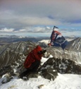
Weather seemed to hold. We emerged from a rather narrow rocky gully to reach the Fourmile creek road a few hundred feet below the gate closure and stopped for a quick break with our backs towards Sheridan and Sherman.
Rather narrow, rocky gully. We nick-named it a "cable route"
Lynn emerges from the rocky gully a.k.a. "cable route" as it merges with the Fourmile creek road.
After 10 or 15 minutes or so we turned around to find that the weather conditions have changed drastically - thick, milky clouds were enveloping the peaks.
Last look at Sherman before clounds move in.
Clouds are in.
We conceded that not trying to summit more than one peak today was a prudent idea for us (given our moderate pace today), and made haste down the road. Within the remaining hour, the visibility got progressively worse, and the snow was coming down heavily just as we reached the car shortly after 1pm.
Mining ruins #4
Came full circle. Almost back at the car.
We were thankful that we got to enjoy great weather while it lasted and to summit a peak in a beautiful area. We sure will be back.
I believe this is called a "weather window" (on the drive out)
Just another day in paradise
P.S. Sherman is a great mountain and SurfNTurf is totally off base
Thumbnails for uploaded photos (click to open slideshow):
And Sherman taketh away. Most of the time, in my case, it taketh away. Nice work ladies. When you go back later to ski it, please make sure not to call me.
Nice! Sorry we missed you, but we left a lot later (8:30) and went up Sheridan first, hung out a lot with Steve and Aaron a bit, ran into Double DD on Sherman, had a fine day as you obviously did, the weather was very benign for deep ”winter”, but the drive home sure did suck, ouch!
that we talked each other into this one! It looks like the mountains might smile upon us for your birthday next week (they sure do like us). Looking forward to another great day (days?) with you!!
Beautiful cloud action made for a great day in the basin.
Jim - thanks
Jeff - on the contrary. You should try to hike Sherman with us sometimes. Maybe you'll get a chance to see a gentle, milder and more beautiful side of the mountain.
Caution: The information contained in this report may not be accurate and should not be the only resource used in preparation for your climb. Failure to have the necessary experience, physical conditioning, supplies or equipment can result in injury or death. 14ers.com and the author(s) of this report provide no warranties, either express or implied, that the information provided is accurate or reliable. By using the information provided, you agree to indemnify and hold harmless 14ers.com and the report author(s) with respect to any claims and demands against them, including any attorney fees and expenses. Please read the 14ers.com Safety and Disclaimer pages for more information.
Please respect private property: 14ers.com supports the rights of private landowners to determine how and by whom their land will be used. In Colorado, it is your responsibility to determine if land is private and to obtain the appropriate permission before entering the property.


")


")
")


")

 Early morning cloud action")
 Sunrise")
 Blue skies ahead?")
 Maybe not.")
 Mining ruins #1")
 Mining ruins #2")
 Mining ruins #3 (high ruins)")
 Going up the Sherman-Sheridan saddle")
 cornice detail")
 Clouds lift up momentarily")
 Alas, not for long. The storm is coming")
 Looking back at Sheridan")
 Iowa Gulch")
 Sherman's summit ridge in a cloud")
 Near the summit (false summit?)")
 Departing from the summit (no time to sign the register)")
 Cloud action on the descent")
 One minute Sheridan looks like this")
 Soon thereafter like this")
 Our descent gully. Skiable, if you don't mind hard-packed crusty snow")
 Rather narrow, rocky gully. We nick-named it a \"cable route\"")
 Lynn emerges from the rocky gully a.k.a. \"cable route\" as it merges with the Fourmile creek road.")
 Last look at Sherman before clounds move in.")
 Clouds are in.")
 Mining ruins #4")
 Came full circle. Almost back at the car.")
 I believe this is called a \"weather window\" (on the drive out)")
 Just another day in paradise")
")