Download Agreement, Release, and Acknowledgement of Risk:
You (the person requesting this file download) fully understand mountain climbing ("Activity") involves risks and dangers of serious bodily injury, including permanent disability, paralysis, and death ("Risks") and you fully accept and assume all such risks and all responsibility for losses, costs, and damages you incur as a result of your participation in this Activity.
You acknowledge that information in the file you have chosen to download may not be accurate and may contain errors. You agree to assume all risks when using this information and agree to release and discharge 14ers.com, 14ers Inc. and the author(s) of such information (collectively, the "Released Parties").
You hereby discharge the Released Parties from all damages, actions, claims and liabilities of any nature, specifically including, but not limited to, damages, actions, claims and liabilities arising from or related to the negligence of the Released Parties. You further agree to indemnify, hold harmless and defend 14ers.com, 14ers Inc. and each of the other Released Parties from and against any loss, damage, liability and expense, including costs and attorney fees, incurred by 14ers.com, 14ers Inc. or any of the other Released Parties as a result of you using information provided on the 14ers.com or 14ers Inc. websites.
You have read this agreement, fully understand its terms and intend it to be a complete and unconditional release of all liability to the greatest extent allowed by law and agree that if any portion of this agreement is held to be invalid the balance, notwithstanding, shall continue in full force and effect.
By clicking "OK" you agree to these terms. If you DO NOT agree, click "Cancel"...
To commemorate the tenth anniversary of the 9/11 attacks, a few of us from the Air force Academy decided to skip the ceremonies and hike Colorado's highest peak, accompanied by a reminder of the day's tragic events and what's transpired since.
As usual, we rendezvoused in Colorado Springs and departed shortly after 0415 with a party of six in one SUV and made good time to the South Elbert Trailhead and the East Ridge approach. The 4WD road to the trailhead was really no problem at all and should be easily passable by any all-wheel drive car. There were several Subarus and similar vehicles that seemed to have no trouble. We were in an LR3 and it was easy, if slow. We arrived shortly before 0700 and assembled our gear for the hike before taking a pre-climb photo and setting off up the Colorado Trail at 0708
Again, conditions were nearly perfect with little or no wind and starting temperatures in the upper 30s. Several in the group overdressed and were taking off layers within a quarter mile. We started by crossing the little bridge at the trailhead and then covered the quarter mile or so to the trail turnoff quickly. The left-turn towards Elbert is very well marked and unmissable. You turn LEFT up the hill. (Remember that). From there we hiked through some of the most beautiful aspen groves I've seen, though the leaves aren't really even beginning to turn yet.
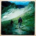
I liked this trail a lot because of the condition of the path and the fact that the grade varies throughout. You'll have a steep stretch of a few hundred meters and then it'll level out and you can make good time. We made good time through the forested areas and noticed frost on the ground plants and near any standing water. The trees opened as we neared 12kft and we had excellent views of the southeast ridgeline coming from Elbert's summit.
Another great aspect of this trail was the lack of people. By the time we'd passed treeline, we had only seen two other people outside of our group. Once we attained the east ridgeline and could see north, we saw the snake of people coming up from the classic route and were happy to have chosen this path.
We passed a few more people as the trail headed above treeline and on the spine of the ridge. We also picked up some wind and temperatures dropped, probably back into the upper 30s or low 40s"at least the wind chill was about that. I added some cotton gloves, but still hiked in two short-sleeve shirts and shorts, with a wide-brimmed hat.
The trail next takes a rather long traverse (or set of traverses) leading to the southwest. The path is not very steep at all here and you can cover a lot of ground quickly on the solid packed path. We were getting hungry for the summit now, too, and thought we would easily make it to the top in under three hours. Our group was scattered at this point, though, with two of us in the lead, passing a few other small groups that had started earlier. It was rather hard to spot the peak at this point, too, though we knew we were not far as we passed through 13,500' and on to 14kft. In fact, I could see a group of people standing around well above me to the north-northwest, but they looked to be relaxing and not on the summit since several other points farther west looked higher.
As the long traverse turned into a series of shorter, steeper switchback up the southeast face of the summit, though, it became happily apparent that we were looking at the summit"almost a false summit in reverse effect!
I made it to the top in 2:31 with my next climbing buddy just a few minutes behind. The remaining four in our group were all on the summit within the next 20 to 25 minutes and we enjoyed a rather large crowd that had gathered in the excellent weather. We had a few passing wind gusts, but it was quite comfortable, despite the fact that some seemed dressed for an Arctic expedition. Some non-threatening clouds were also in the area, but there seemed to be no signs of convection, so we stayed quite a while at the top.
As usual, I took many pictures of other climbers in groups and as individual, as well as photographing a couple of four-legged peak baggers. The nicely crafted summit stone at Elbert is an excellent photo prop, by the way.
One group had ridden/carried their bikes to the summit and was preparing to descend via the East Ridge route. We followed them as they went and it seemed remarkably successful. Later in our descent we saw their tire marks and didn't see any bloody rocks, so we presume they made it down without incident.
Some folks took a few pictures of the trip report author (me) downing my summit soda. That, and the altitude, I will admit made me a little more emotional than I expected as I pulled a new summit registry from my backpack. You see, 10 years and one hour before summiting on this day, I was in the Pentagon when the plane hit. I was uninjured and, frankly, on the other side of the building from the impact, but it was still a day I'll always remember"as were the days that followed. A good friend on the trip made a special tube and new registry for the summit that contains all of the names of those that died on 9/11/01 as well as all of those that have perished defending our nation against terrorism in the years to that day. He added several pages for climbers to sign as well. We passed the registry around and everyone was very happy to sign. We took pictures of the tube, too, and hope that it has a long stay on the summit. If you go, please sign it and feel free to add a personal message. If, at some point, you just can't jam any additional paper into the tube, please send me a message"I'd like to arrange to have it sent back to us here at the Academy.
After taking a few more pictures, snacking and relaxing with others on the summit, we finally at about 1100. As nice as the trail is going up, it's even better going down. I just dread the downhill returns on most 14ers, but the East Ridge of Elbert is probably the easiest, most stable, and fastest descent I've experienced. I did put on my micro-spikes to limit slipping in some spots, but that was hardly an issue. The lead two made it down the mountain in just over 1.5 hours and we were cooling our feet in the stream of the trailhead soon after. We did manage to take some other pictures on the descent, too, especially of the small streams, aspen, and ground cover.
Three others in the group were all down within 30 minutes or so, but our sixth member was missing. Luckily, we had cell phone coverage in the area (AT&T) and we got a call from him. He'd turned left coming down the East Ridge Trail when he hit the Colorado Trail instead of going right. We told him to turn around and backtrack, but then he took some bad advice from other hikers who told him to "stay left" and he'd get back to the trailhead. Well, staying left would get him back to A trailhead, just not THE trailhead. Thirty minutes later he was on Forest Road 122 (our trailhead is on FR 125) and we were trying to vector him south and west to our spot. He finally stumbled into shortly after 1430 and we loaded him quickly and took off. Lessons learned: If you start the day by turning LEFT at the only turn on the trail, be sure to turn RIGHT when you get back to the same point; always have your own topo map or GPS with you; don't follow someone else's instructions after you've figured out what you need to do"especially if you're not sure where you are and there MAY be multiple starting points for that 14er. In the end, all were safe and we count ourselves lucky that there was cell phone coverage. That probably helped us avoid a SAR event.
All-in-all, a great day on our highest peak and an excellent way to peacefully commemorate an horrific day in our nation's history.
Note: ALL of the pictures from this trip are available at my website using this link: http://martyfrance.zenfolio.com/p445588272
I'll have a GPX file posted soon.
Thumbnails for uploaded photos (click to open slideshow):
This reminds me of the last time I climbed Elbert by the same route. It was September 15, 2001, just a few days after 9/11. When I reached the summit, there was a huge American Flag there and I immediately burst into tears remembering all the victims. Your new summit register is absolutely wonderful! Hope I get to sign it!!! Thank you for your bravery and service to our Country!!!!!
We had just finished up on the summit and were eating a little lower when you guys came up. You told us your climb time, Nice work! we did it in about 3 hours and thought we were cooking. I wish we would have hung out near the summit for a little longer it would have been great to sign that register!
Thank you for a great report...and tribute! 9/15/2011 1:26pm
Our group of 4 reached the summit the day after you to find your amazing and touching tribute to 9/11. It touched me because I was working as an air traffic controller that day when we were instructed to clear the skies by our command center as a result of a horrible event in NYC. We didn't immediately understand, but soon did. Your tribute brought back that day as if it occurred yesterday. I will always remember.
Thank you for a great trip report (made me wish we'd taken the east route!), but, more importantly, thank you for your service to our great nation.
Caution: The information contained in this report may not be accurate and should not be the only resource used in preparation for your climb. Failure to have the necessary experience, physical conditioning, supplies or equipment can result in injury or death. 14ers.com and the author(s) of this report provide no warranties, either express or implied, that the information provided is accurate or reliable. By using the information provided, you agree to indemnify and hold harmless 14ers.com and the report author(s) with respect to any claims and demands against them, including any attorney fees and expenses. Please read the 14ers.com Safety and Disclaimer pages for more information.
Please respect private property: 14ers.com supports the rights of private landowners to determine how and by whom their land will be used. In Colorado, it is your responsibility to determine if land is private and to obtain the appropriate permission before entering the property.


")
")
")
")
")
")
")
")
")
")
")
")
")
")
")
")
")
")
")
")
")
")
")
")
")
")
")
")
")
")