Download Agreement, Release, and Acknowledgement of Risk:
You (the person requesting this file download) fully understand mountain climbing ("Activity") involves risks and dangers of serious bodily injury, including permanent disability, paralysis, and death ("Risks") and you fully accept and assume all such risks and all responsibility for losses, costs, and damages you incur as a result of your participation in this Activity.
You acknowledge that information in the file you have chosen to download may not be accurate and may contain errors. You agree to assume all risks when using this information and agree to release and discharge 14ers.com, 14ers Inc. and the author(s) of such information (collectively, the "Released Parties").
You hereby discharge the Released Parties from all damages, actions, claims and liabilities of any nature, specifically including, but not limited to, damages, actions, claims and liabilities arising from or related to the negligence of the Released Parties. You further agree to indemnify, hold harmless and defend 14ers.com, 14ers Inc. and each of the other Released Parties from and against any loss, damage, liability and expense, including costs and attorney fees, incurred by 14ers.com, 14ers Inc. or any of the other Released Parties as a result of you using information provided on the 14ers.com or 14ers Inc. websites.
You have read this agreement, fully understand its terms and intend it to be a complete and unconditional release of all liability to the greatest extent allowed by law and agree that if any portion of this agreement is held to be invalid the balance, notwithstanding, shall continue in full force and effect.
By clicking "OK" you agree to these terms. If you DO NOT agree, click "Cancel"...
It was the best of climbs, it was the worst of climbs . . .
I've had a few days to ruminate on this hike now, and I think it's safe to say that it could count as both my favorite and least favorite 14er trek. It combined breathtaking views and some great ridge-running with a boring, miserable, mosquito-infested approach. Every part of this hike above about 11,750 feet was an absolute pleasure; everything below that elevation I could have done without. In total my route was about 30 miles with around 9,250 feet of vertical gain, but this includes the 15 miles I spent on Tigiwon Road due to the road closure and a 3-mile detour on the Fall Creek Trail. Even without this additional mileage, however, this route is pretty strenuous. I think it would be extremely difficult to do in one day even from the Half Moon/Fall Creek Trailhead.
I got a much later start from Denver than I wanted and didn't end up leaving until around 12:20 p.m. on Sunday, July 17th. I also got stuck in traffic on I-70 for an hour, so I didn't make it to the trailhead until nearly 3 p.m. After loading up my gear, I started up Tigiwon Road at about 3:10. In most years, the 7.5-mile Tigiwon Road is drivable all the way to the Half Moon/Fall Creek Trailhead, but it is currently closed due to logging operations in the Holy Cross Wilderness. This added about 15 miles roundtrip to the route. This might not have been so bad if the road wasn't swarming with mosquitoes. I think I expended more energy swatting mosquitoes than I did hiking!
I stopped briefly for a snack at the Tigiwon Community House at around 5:10 p.m. and made it to the Half Moon/Fall Creek Trailhead at 6:30. I had hoped to make it up to the Notch Mountain Shelter, but this proved overly optimistic, especially when I missed the Notch Mountain Trail turnoff. There is a stream crossing on the Fall Creek Trail at which the trail turns sharply uphill and follows a few switchbacks until reaching the junction with the Notch Mountain Trail. I had been too busy taking photos of the stream crossing to notice this, and instead continued straight across the stream. Although I soon realized my error and headed uphill to regain the Fall Creek Trail, this caused me to bypass the Notch Creek Trail turnoff. In the growing darkness, I actually continued on the Fall Creek Trail nearly to Lake Constantine before realizing my mistake. I therefore resigned to spend the night just north of Lake Constantine and crawled into my bivvy and fell asleep at around 11 p.m. This detour added roughly 3 miles to an already long hike.
When I woke up at around 5:30 a.m. on Monday, July 18th, I could get a clear glimpse of the surrounding topography in the daylight and quickly figured out that I was far south of the Notch Mountain Trail. I backtracked along the Fall Creek Trail a bit past the Notch Mountain Trail to see where I had gone wrong, then headed up the Notch Mountain Trail at about 8 a.m. I was at the Notch Mountain Shelter by 11 a.m., too late to start across the Halo Ridge. This was fine with me; I didn't mind spending the rest of the day resting, praying, and watching marmots as I enjoyed views of the Cross Couloir.
A view of the Gore Range taken from the Tigiwon Community House.
Navigational error: I needed to turn right and head up a switchback here; I instead kept going straight and missed the Notch
The Notch Mountain Shelter and Point 13,248.
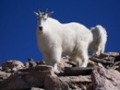
One of several marmots who entertained me on Notch Mountain.
The view from Notch Mountain: (left to right) Point 13,831, Mount of the Holy Cross, and Holy Cross's north ridge.
This photo shows a good portion of the Halo Ridge, from Point 13,373 to Point 13,831 and then over to Holy Cross.
A close-up of the Holy Cross Couloir.
It's hard not to get inspired by this photo.
Spending the night at the Notch Mountain Shelter was fantastic. It was great to be able to safely and dryly watch the afternoon thunderclouds roll in from 13,000 feet. The neighborhood marmots were quite entertaining, I slept like a baby, and even the rat that made his appearance as I was preparing coffee at 4 a.m. in the morning on Tuesday, July 19th didn't cause too much trouble. I was also able to take some great sunrise photos before I started across the Halo Ridge at 6:15 a.m.
Interior of the Notch Mountain Shelter--very cozy.
This marmot refused to let my socks dry on my trekking poles.
Stormclouds rolling in.
This brown rat tried to nab my morning coffee.
Watching the sun rise from Notch Mountain.
A touch of alpenglow on the Notch Mountain Shelter.
Holy Cross at dawn.
I had a blast hiking around the Bowl of Tears on Halo Ridge, and I made fairly good time. I was on the top of Point 13,831 by 10 a.m. and on the summit of Mount of the Holy Cross by 11:15. Except for a benign snowfield just above the Teardrop Couloir, I was able to avoid snow for the entire route. Gerry Roach gives this route a Class 2 rating. I would probably lean toward Class 2+, as I found myself putting both hands down for balance throughout several sections of the Halo Ridge. Regardless, the route required no technical moves and also had very little exposure. It was some of the best hiking I've done above 13,000 feet.
The three Halo Ridge 13ers: Point 13,248, Point 13,373, and Point 13,831.
A closer view of Point 13,373.
The Teardrop Couloir between Point 13,831 and Holy Cross.
Clouds passing over the top of Holy Cross.
From the top of Point 13,373, looking back across Point 13,248 toward Notch Mountain. The Bowl of Tears lies below.
About half-way around the Halo Ridge, looking at Point 13,831.
The Teardrop Couloir.
Looking back along the Halo Ridge from Point 13,831.
The last section of the Halo Ridge leading up to the summit of Holy Cross.
There is basically nothing holding this cornice onto the mountain.
Looking down the Holy Cross Couloir. My hat goes off to those of you who have skied or boarded down this!
Looking across to Notch Mountain.
My descent down the north ridge was fairly uneventful. I followed Gerry Roach's admonition to stick close to the ridge crest, but I could see how easy it would be to veer too far to the west, as there are several fairly well-defined paths that lead in that direction. I crossed the East Cross Creek at 3:20 p.m. and then started gaining elevation again until I reached the top of the Half Moon Pass at 4:45. An hour later I was at the Half Moon/Fall Creek Trailhead, then had to begin the long slog back down Tigiwon Road. I was at the Tigiwon Community House at 6:45 and made it back down to my car at 8:40 p.m.
Lake Patricia and the Half Moon Pass. The north ridge of Holy Cross is on the far left.
Holy Cross from the northeast and the Angelica Couloir.
Despite the onerous approach, there is still a great deal of satisfaction to be found in this route. The view of the Cross Couloir from Notch Mountain alone is worth the effort. Hiking along the Halo Ridge is also extraordinary. Finally, it's pretty rewarding to encircle an entire mountain and get views of it from every angle. Being able to examine all three of Holy Cross's famous couloirs was pretty neat. With Tigiwon Road reopened and armed with plenty of mosquito repellent, a lot of the negative aspects of my experience will be able to be avoided.
I did not see another hiker on this route from the time I started up the Notch Mountain Trail until I returned to my car. I would never advocate attempting to summit any 14er alone; there are just too many things that can go wrong (a simple sprained ankle can kill you up there). Nevertheless, I had soloed something like 19 of my 26 previously completed 14ers, so I felt fairly comfortable hiking and camping by myself. I'm a loner, I enjoy solitude, I don't make friends easily, and I've accepted the inevitable risks that come with going solo. That being said, I was a bit afraid of tackling Mount of the Holy Cross, the infamous "Bermuda Triangle" of Colorado, by myself. Its habit of swallowing hikers without a trace is well-known to members of this site. I explained my pre-hike apprehension about this route to my father after I had returned from it, and he asked a reasonable question: If I had been nervous about soloing this mountain, then why had I gone alone? The truth was, the fact that I was afraid of hiking up Mount of the Holy Cross alone was the very reason I had to do it. I think Edmund Hillary's famous quote summarizes why many of us spend our weekends above 14,000 feet: "It is not the mountains we conquer, but ourselves." For me, soloing Mount of the Holy Cross had little to do with standing alone on the summit of a mountain; it had everything to do with surmounting my own self-doubt. I returned having conquered both the mountain without and the greater mountain within.
My route, without showing detour to Lake Constantine (click on image to enlarge).
Thumbnails for uploaded photos (click to open slideshow):
Nice trip report. I totally understand your motives, your self-doubt and your need to challenge your inner mountain. I have this paragraph as my personal axiom:
And from the mountain we shall get nothing but the truth. It lays bare our weaknesses, while opening us to a source of strength. We learn from it the limit of our capabilities, and while it rewards us for success and for unsuccessful effort more truly than we know, we must never expect it to pass over a mistake.
I did 51 of the 14ers by myself the first time, although many times there were other people around. Let's all give a salute to the men and women of mountain rescue organizations who come to selflessly help us self-preservationally-challenged peeps when the mountain does not pass over a mistake.
Wow! Super nice! Did the Half Moon Trail route last year - still a fair amount of snow and allowed you to capture some fine shots esp of The Cross - way to go! Thanks for posting! 8)
Yeah, this is one of my absolute favorites! Don't know if I'd do it again hiking an extra 15 miles though; it's pretty grueling even without hiking Tigiwon! Great job! It is one fantastic climb! Nice marmot shot too! That's got to be a classic!
I love the marmot. Great shots of the Cross as well. This still is my favorite peak.
Caution: The information contained in this report may not be accurate and should not be the only resource used in preparation for your climb. Failure to have the necessary experience, physical conditioning, supplies or equipment can result in injury or death. 14ers.com and the author(s) of this report provide no warranties, either express or implied, that the information provided is accurate or reliable. By using the information provided, you agree to indemnify and hold harmless 14ers.com and the report author(s) with respect to any claims and demands against them, including any attorney fees and expenses. Please read the 14ers.com Safety and Disclaimer pages for more information.
Please respect private property: 14ers.com supports the rights of private landowners to determine how and by whom their land will be used. In Colorado, it is your responsibility to determine if land is private and to obtain the appropriate permission before entering the property.


 Point 13,831, Mount of the Holy Cross, and Holy Cross's north ridge.")


.")
 A view of the Gore Range taken from the Tigiwon Community House.")
 Navigational error: I needed to turn right and head up a switchback here; I instead kept going straight and missed the Notch")
 The Notch Mountain Shelter and Point 13,248.")
 One of several marmots who entertained me on Notch Mountain.")
 The view from Notch Mountain: (left to right) Point 13,831, Mount of the Holy Cross, and Holy Cross's north ridge.")
 This photo shows a good portion of the Halo Ridge, from Point 13,373 to Point 13,831 and then over to Holy Cross.")
 A close-up of the Holy Cross Couloir.")
 It's hard not to get inspired by this photo.")
 Interior of the Notch Mountain Shelter--very cozy.")
 This marmot refused to let my socks dry on my trekking poles.")
 Stormclouds rolling in.")
 This brown rat tried to nab my morning coffee.")
 Watching the sun rise from Notch Mountain.")
 A touch of alpenglow on the Notch Mountain Shelter.")
 Holy Cross at dawn.")
 The three Halo Ridge 13ers: Point 13,248, Point 13,373, and Point 13,831.")
 A closer view of Point 13,373.")
 The Teardrop Couloir between Point 13,831 and Holy Cross.")
 Clouds passing over the top of Holy Cross.")
 From the top of Point 13,373, looking back across Point 13,248 toward Notch Mountain. The Bowl of Tears lies below.")
 About half-way around the Halo Ridge, looking at Point 13,831.")
 The Teardrop Couloir.")
 Looking back along the Halo Ridge from Point 13,831.")
 The last section of the Halo Ridge leading up to the summit of Holy Cross.")
 There is basically nothing holding this cornice onto the mountain.")
 Looking down the Holy Cross Couloir. My hat goes off to those of you who have skied or boarded down this!")
 Looking across to Notch Mountain.")
 Lake Patricia and the Half Moon Pass. The north ridge of Holy Cross is on the far left.")
 Holy Cross from the northeast and the Angelica Couloir.")
 My route, without showing detour to Lake Constantine (click on image to enlarge).")