Download Agreement, Release, and Acknowledgement of Risk:
You (the person requesting this file download) fully understand mountain climbing ("Activity") involves risks and dangers of serious bodily injury, including permanent disability, paralysis, and death ("Risks") and you fully accept and assume all such risks and all responsibility for losses, costs, and damages you incur as a result of your participation in this Activity.
You acknowledge that information in the file you have chosen to download may not be accurate and may contain errors. You agree to assume all risks when using this information and agree to release and discharge 14ers.com, 14ers Inc. and the author(s) of such information (collectively, the "Released Parties").
You hereby discharge the Released Parties from all damages, actions, claims and liabilities of any nature, specifically including, but not limited to, damages, actions, claims and liabilities arising from or related to the negligence of the Released Parties. You further agree to indemnify, hold harmless and defend 14ers.com, 14ers Inc. and each of the other Released Parties from and against any loss, damage, liability and expense, including costs and attorney fees, incurred by 14ers.com, 14ers Inc. or any of the other Released Parties as a result of you using information provided on the 14ers.com or 14ers Inc. websites.
You have read this agreement, fully understand its terms and intend it to be a complete and unconditional release of all liability to the greatest extent allowed by law and agree that if any portion of this agreement is held to be invalid the balance, notwithstanding, shall continue in full force and effect.
By clicking "OK" you agree to these terms. If you DO NOT agree, click "Cancel"...
Peak(s):
Little Bear Peak - 14,041 feet
"South Little Bear" - 14,028 feet
Peaks: Little Bear and South Little Bear
Route: Southwest Ridge
I was happy to have Aggieclimber86 join me for my "finishing" 14er on this cloudless Friday in June. We did not see a single person all day, on any of the peaks, or by the lakes. Perhaps just poor eyesight? Although I was not in optimum shape yet, Jamie pointed out that we wanted to take advantage of the long hours of daylight this time of year, and I am very glad we did. Our trip time - 14.5 hours, from 5 AM to 7:30 PM. You want a perfect weather day due to the very long time you spend on the ridge above 13,000'.
Since we found this trip to be well described in previous reports, I only want to add what I hope are a few helpful notes and suggestions for this less traveled route.
Trailhead:
If you look at the Google aerial and street maps for the large subdivision northeast of Highways 150 and 160, the trailhead is located at the northeast corner of the northern most street - 20 4th Street and Finton Avenue.
We found LynnKH's directions to this trailhead to be very helpful, and they got us there. However, I want to add a few additional tidbits for those who like more detail. I couldn't figure out how you could drive east and then turn right and end up at the base of the mountain to the north. Also, the highway numbers were reversed which I have corrected below:
From Highway 160, turn North on 150 and set your odometer.
After 2.6 miles turn right (reset the odometer) onto 18th Street.
Drive straight east on this dirt road for 2.4 miles where you pass a road on your right (the unlabeled and diagonal Grant Avenue on Google Maps)
After 2.5 miles on this road, which suddenly curves around to the left 90 degrees, turn right at the fork (onto what is Grant Avenue) and head northeast.
After 3.1 miles, you should pass a white camper trailer currently parked on the right. See photo below:
Trailer beside road to trailhead.
The road gets rough at 3.5 and a 4wd high clearance is necessary here.
After 4.4 miles the road takes a hard left (from Finton Avenue onto 20 4th Street). Park here.
The trail begins by heading straight north at this corner. BTW, we did not see any street signs mentioned above during the drive, except for possibly 18th Street out by Highway 150.
Night before - We checked out the trailhead and beginning of the hike the night before, hiking in perhaps a quarter mile. This was very helpful for our dawn start when the ribbons are much less visible. It took us 30 minutes to reach the trailhead from the Fort Garland Motor Inn, our second stay at this clean little motel.
Route/ribbons:
Overview - Before starting the trip, we tried to mentally prepare for what we anticipated would be a horrendous battle to reach tree line. However, we loved the route we followed, mostly because it seemed absent the extensive bushwhacking, route finding and losing, loose talus, and general flailing described in some previous reports. We very much enjoyed the entire day, with the only exception being that we ran out of energy long before we ran out of trail.
In summary, we followed a very well marked path all of the way up to the first large open boulder field on the south side of the ridge. The path through the remaining trees above this boulder field was less well marked, but since you are following the ridge anyway, this was not a problem for us, either going up or down. Just follow the ridge!
Jamie following orange ribbons in the shadow of Little Bear.
Ribbons - Many of the original ribbons (surveyors tape) are fading to white, and deteriorating and falling off the branches. New orange, white, and a few yellow ribbons have been added. We added a few pink ribbons along the way at what we considered key turning points, or to fill gaps in the ribbons. There are plenty of ribbons to get you there, but you will only be able to see and follow all of them in daylight. If you lose the ribbon path, stop and go back and find it! It is really worth it, and the path is there. The payoff for us was a pleasant hike with nothing I would consider bushwhacking, no loose talus to speak of, and no flailing around, wasting time and energy. On the way back, wearing shorts and a t-shirt (Jamie wore shorts up and back and was very happy with his choice), we had little to no scratches. I can only find 2 half inch red marks the morning after. Yes, there are some scratchy branches and small Yucca plants along the way, and I had a few twigs in my backpack and stickers in my shoes. One trick for me was to plant my pole at the base of an intruding bush, and simply push it out of the way as I walked by. Based on the very unpleasant descriptions about this section in other reports, we were surprised and relieved at what we found.
Fork in the Ribbon Road - When we hiked in a short distance the night before, we noticed a fork in the ribbon-marked path when it was heading east and crossed a tiny road/trail which headed north. I first followed the ribbon path east and soon lost sight of any additional markings. However, I believe continuing northeast from this option will prove to be the most direct route, but I would wait until it is better marked or use a GPS to arrive at the audio speaker mentioned below. A waypoint for the speaker anyone?
Instead, we took the very well ribbon-marked road/trail north at this first juncture, which eventually leaves the vanishing road and curves east, then runs into another larger north/south dirt road. The path turns right/south along this road, which unfortunately is also downhill. After going about 50 to 100 yards, and right where you wonder if you are headed back toward your car, look for extra ribbons and a small, square audio speaker on your left sitting on the ground under some trees, on the east side of the road. The correct path leaves the road here and heads east toward Tobin Creek. I say this because we also noticed ribbons leading southwest from this point back toward the car from the speaker. This would appear to be the most direct path back to the car at the end of the day, avoiding the better marked, but circular path we took. But who knows if there are ribbons the entire way.
Tobin Creek - There was no water in Tobin Creek where we crossed it, although I thought I could hear it flowing further north later on. The route actually descends into the creek bed, heads north along the creek bed for perhaps a hundred yards, then heads up and east out of the creek bed to gain the ridge on the creek's east bank.
The Ridge - The rest of your day is spent following this ridge on the east side of the creek, which continues all the way to Little Bear. I estimate the entire remaining route is never more than 100 yards away from the high point of this ridge. The ridge initially starts out by heading north along with the creek, then curves around to the northeast. We left a couple of our water bottles at this curve (1 hour from the trailhead), and also at the last of the trees on the ridge (about 3 hours from the trailhead). Unfortunately, neither were still in the shade by the time we got back to them at the end of the day! Yum, hot water tasting like plastic.
Above tree line, we followed others advice to stay on the ridge, or very close to it. It is very good advice. The hiking is much more solid. We occasionally hiked slightly to the right/south side of the ridge to try minimize the strong winds. But, to echo previous reports, above tree line stick to the ridge! The elevation losses are just too minimal to attempt to avoid by skirting around these mini-summits on loose talus.
Traverse - We reached South Little Bear about 12:30, and left our packs there. The traverse took us 50 minutes north, and 30 minutes back. In various places, we each took slightly different routes north, and again near South Little Bear on the way back, where we hiked up more toward the right or east. In other words, we found a few options in some of the more difficult places. Although there are many loose rocks poised to go, we were pleased to send not a single one tumbling down the hillside.
Cary on SLB, celebrating with Cheetos. Blanca on the right, LB summit on left.
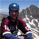
Jamie on summit of LB.
Wind - It was quite windy (say 30 to 40 MPH) from just below tree line to the summit of South Little Bear, concerning us all morning about the traverse. Fortunately, the wind was mild and not really a factor during the traverse. This seems to be a common occurrence. I also appreciated that the wind was mostly at our backs on the way up, encouraging us along, and cooling us down during the hot afternoon trek back.
LB above to the left, SLB up to the right.
It was a very enjoyable way to complete my final 14er! Thanks, Jamie! You made it happen, bud!
Cary headed toward LB from SLB.
Thumbnails for uploaded photos (click to open slideshow):
What a day huh?! Awesome job on finishing the 14ers with the infamous Little Bear! I can't think of a thing that I would have rather done yesterday than conquer the Mama Bear traverse with you. Keep climbing at least until you get to your long term goal of 100 14er summits!!! I may need your help on 1 or 2 of my last 5!!
Way to get em all! Thanks for posting your photos. It looks like there isn't much snow left. I was thinking about LB-Blanca-Ellingwood in the next few weeks. One of your photos seems to have the LB-Blanca traverse shown with almost no snow. I'd greatly appreciate your thoughts on conditions for the traverse.
I thought about your question further, and was wondering which route you planned to use on LB. We noticed a fan of snow and probably ice below the hourglass. It looks like it would be hard to get up to the hourglass. We could not look into the hourglass from our angle to see if it is clear or not. My guess would be that it is not. Again, if you would like me to send additional photos, please send your email address to me.
Thanks,
Cary
Thank you, Johnson! I am not aware of a congrats list. Does it also include a nice 14er plaque to put on my wall?
Caution: The information contained in this report may not be accurate and should not be the only resource used in preparation for your climb. Failure to have the necessary experience, physical conditioning, supplies or equipment can result in injury or death. 14ers.com and the author(s) of this report provide no warranties, either express or implied, that the information provided is accurate or reliable. By using the information provided, you agree to indemnify and hold harmless 14ers.com and the report author(s) with respect to any claims and demands against them, including any attorney fees and expenses. Please read the 14ers.com Safety and Disclaimer pages for more information.
Please respect private property: 14ers.com supports the rights of private landowners to determine how and by whom their land will be used. In Colorado, it is your responsibility to determine if land is private and to obtain the appropriate permission before entering the property.


 Trailer beside road to trailhead.")
 Cary on SLB, celebrating with Cheetos. Blanca on the right, LB summit on left.")
 Jamie following orange ribbons in the shadow of Little Bear.")
 LB above to the left, SLB up to the right.")
 Jamie on summit of LB.")
 Cary headed toward LB from SLB.")