Download Agreement, Release, and Acknowledgement of Risk:
You (the person requesting this file download) fully understand mountain climbing ("Activity") involves risks and dangers of serious bodily injury, including permanent disability, paralysis, and death ("Risks") and you fully accept and assume all such risks and all responsibility for losses, costs, and damages you incur as a result of your participation in this Activity.
You acknowledge that information in the file you have chosen to download may not be accurate and may contain errors. You agree to assume all risks when using this information and agree to release and discharge 14ers.com, 14ers Inc. and the author(s) of such information (collectively, the "Released Parties").
You hereby discharge the Released Parties from all damages, actions, claims and liabilities of any nature, specifically including, but not limited to, damages, actions, claims and liabilities arising from or related to the negligence of the Released Parties. You further agree to indemnify, hold harmless and defend 14ers.com, 14ers Inc. and each of the other Released Parties from and against any loss, damage, liability and expense, including costs and attorney fees, incurred by 14ers.com, 14ers Inc. or any of the other Released Parties as a result of you using information provided on the 14ers.com or 14ers Inc. websites.
You have read this agreement, fully understand its terms and intend it to be a complete and unconditional release of all liability to the greatest extent allowed by law and agree that if any portion of this agreement is held to be invalid the balance, notwithstanding, shall continue in full force and effect.
By clicking "OK" you agree to these terms. If you DO NOT agree, click "Cancel"...
Date of Climb : 6/19/11
Peaks Climbed :
1) Mt Elbert - 14433'
Distance : 9.0 miles
Elev Gain : 4539'
Time : ~10 hrs, 7am - 5pm, Ascent 5hrs, Descent 5 hrs
Ascent Party : John B. & Allison B.
I spent the day climbing Colorado's highest mountain with my youngest daughter on Father's Day. We drove out that morning leaving home at 4a. The forecast called for snow & rain by 3p and strong winds for the day. Fortunately the weather held beautifully for us all day!
The plan was to climb the NNE ridge per Roach's NE ridge Class 2 variation & descend the standard NE route. However, given the weather forecast & no real beta (pics) about the non-std route, we opted to ascend the std route, and then check out the new route for descent if the weather was good.
Alli negotiating the only real stream of the day.
Mt Elbert trail turn-off from the CO trail at 10560'.
Winds started gusting near 13000'.
Finally getting around that big bump at 13700' we'd been staring at for so long. Can see all the way to Turquoise Lake & Leadville.
Stunning views of Massive, Oklahoma, Deer, & K49 at 13850'.
Alli climbing the final ridgeline to the summit.
A look at the NNE ridge. I knew the 1st 1000' would be the toughest. Would we face scree slides?
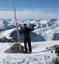
Allison on the summit of Colorado. Her 5th 14er and 10th State Highpoint.
Alli & her dad on Mt Elbert's summit. What a great Father's Day!
Starting the descent of the NNE ridge. A giant cairn marks the start near 14360'. The slope is somewhat steep, but the scree holds firm, and there seems to be a faint trail mostly here & there.
Looking down the NNE ridge.
Looking up the NNE ridge. Some spots rockier than others. Easy Class 2 if stay on the E side. We ended up on the W side to avoid some snow and got into a little Class 3 section.
At the 13380' N ridge / NNE ridge saddle. We could now see the storm coming in from the NW.
We decided to traverse the same contour level rather than climb all the bumps along the ridgeline.
Of course we came across a few snow fields we could not avoid - knee deep in most cases (no wonder not melted yet).
Full view of NE, N, & NNE ridges.
Not only did this NNE route provide a bit of off-trail adventure, but also stunning views.
Then there were some fun sections (not like that beautiful CO Trail).
Alli resting & viewing Mt Elbert's std NE ridge route.
We could see Emerald Lake and the TH from 11800'.
We kept to the NNE ridgeline very well. We came across a lot of old & faint trails, so the travel through the forest was unexpectedly nice.
Topo Plan & Route. The yellow is actual 9 mi & 4539' elev gain. The green was the plan (not including switchbacks) and only predicted 6.6 mi.
GE view. Red is actual path, Black plan. The CO Trail really takes you way S.
Overall, a fantastic day! Don't trust the weather forecast (unless >60%).
Thumbnails for uploaded photos (click to open slideshow):
Congratulations to you and your daughter! 6/20/2011 10:31pm
My brother and I are doing the NE route on Wednesday for his 22nd birthday. It does not look like you carried or used snowshoes. Was there a need for them or could we leave the weight behind?
We encountered snow piles at 10K along std NE route, but each had stomped paths through them. On the NNE ridge we again encountered snow, but only sloshed thru a few for at most 10 yards. Nice to cool down the feet. No problem w/o snowshoes or gaiters. Actually we saw 1 person going up the std NE route carrying no pack.
Thanks for the great beta we are headed up there this weekend. I don't know if the snowfall Monday changes anything but it's supposed to be hot later this week so I'm guessing no.
Thanks for the trip report! Heading up to Elbert on Saturday
A fantastic father's day with your youngest! It's about time to get my little ones up to Sherman
Caution: The information contained in this report may not be accurate and should not be the only resource used in preparation for your climb. Failure to have the necessary experience, physical conditioning, supplies or equipment can result in injury or death. 14ers.com and the author(s) of this report provide no warranties, either express or implied, that the information provided is accurate or reliable. By using the information provided, you agree to indemnify and hold harmless 14ers.com and the report author(s) with respect to any claims and demands against them, including any attorney fees and expenses. Please read the 14ers.com Safety and Disclaimer pages for more information.
Please respect private property: 14ers.com supports the rights of private landowners to determine how and by whom their land will be used. In Colorado, it is your responsibility to determine if land is private and to obtain the appropriate permission before entering the property.


")
")
")
")
")
")
")
")
")
")
")
")
")
")
")
")
")
")
")
")
")
")
")