Has anyone done, or have information on, the traverse between Paiute and Algonquin?
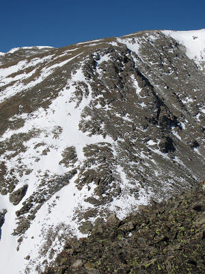
The attached picture makes it look like a pretty good down climb from the summit of Paiute to the ridge line, but there could also be an easier way. A Upper Coney Lake traverse (Audubon-> Paiute-> "Algonquin" ->Coney Island) sounds pretty fun actually. Maybe counter clock-wise would be best actually.
Paiute to "Algonquin" traverse
Forum rules
- This is a mountaineering forum, so please keep your posts on-topic. Posts do not all have to be related to the 14ers but should at least be mountaineering-related.
- Personal attacks and confrontational behavior will result in removal from the forum at the discretion of the administrators.
- Do not use this forum to advertise, sell photos or other products or promote a commercial website.
- Posts will be removed at the discretion of the site administrator or moderator(s), including: Troll posts, posts pushing political views or religious beliefs, and posts with the purpose of instigating conflict within the forum.
For more details, please see the Terms of Use you agreed to when joining the forum.
-
Dave B

- Posts: 2397
- Joined: 6/14/2010
- Trip Reports (9)
Paiute to "Algonquin" traverse
- Attachments
-
- PaiuteN.Face.jpg (185.06 KiB) Viewed 1730 times
Make wilderness less accessible.
-
ajkagy

- Posts: 2294
- Joined: 1/7/2007
- Trip Reports (0)
- Contact:
Re: Paiute to "Algonquin" traverse
bump on this. While I've been up on paiute several times I don't have any beta on the connecting ridge to the north. I always thought the connecting ridge off to the west over to thunderbolt looked enticing as well. Both ridges are pretty minimally traveled
http://wanderingthemountains.com/" onclick="window.open(this.href);return false;
-
Derek

- Posts: 1156
- Joined: 5/22/2006
- Trip Reports (57)
- Contact:
Re: Paiute to "Algonquin" traverse
No info from me, sorry, but I am very interested as well. For some reason, I had always assumed that it was not a good route between the two, but I dont recall if that was just from looking at a map or from something that I had read...maybe on 14erWorld or something? My plan for this year is head out straight from Sawtooth Mountain to grab Algonquin. After getting a good look at the east slopes of Pt12155 this April (the point between Algonquin and Sawtooth), descending these slopes look very doable and would prevent a resummit of Sawtooth. The slopes would leave you in the saddle between Coney Island and Algonquin.
East slopes of Pt12155:
Regardless, finding out the traverse between Paiute and Algonquin is possible would probably make me change my mind. Hopefully someone chimes in.
East slopes of Pt12155:
Regardless, finding out the traverse between Paiute and Algonquin is possible would probably make me change my mind. Hopefully someone chimes in.
Very interesting, never thought of this. Looking through my photos from Thunderbolt, I dont even see that I took a picture looking east at the ridge!ajkagy wrote:I always thought the connecting ridge off to the west over to thunderbolt looked enticing as well.
-
John Prater
- Posts: 216
- Joined: 2/4/2007
- 14ers: 58 58
- 13ers: 343 2
- Trip Reports (0)
Re: Paiute to "Algonquin" traverse
My photos going from Algonquin to Paiute in 2008: http://www.flickr.com/photos/homieprate ... 726582135/.
I think we were on the east side of the ridge (grassy ledges, crux loose section, lots of scrambling, up to 4th class) until the final notch. Above the notch, up a gully (good rock, 3rd class) on the west side of the ridge, then crossed back to the east side. Then the crux of the route for us, a short (30-foot?) wall. We looked at several options. My buddy Bill soloed up one option, then belayed two of us up another option. Don't recall the exact difficulty, but I want to say 5.6-5.7? Short scramble to the summit of Paiute above the crux.
I think we were on the east side of the ridge (grassy ledges, crux loose section, lots of scrambling, up to 4th class) until the final notch. Above the notch, up a gully (good rock, 3rd class) on the west side of the ridge, then crossed back to the east side. Then the crux of the route for us, a short (30-foot?) wall. We looked at several options. My buddy Bill soloed up one option, then belayed two of us up another option. Don't recall the exact difficulty, but I want to say 5.6-5.7? Short scramble to the summit of Paiute above the crux.
-
Dave B
- Posts: 2397
- Joined: 6/14/2010
- Trip Reports (9)
Re: Paiute to "Algonquin" traverse
Wow, really helpful! Thanks, John!John Prater wrote:My photos going from Algonquin to Paiute in 2008: http://www.flickr.com/photos/homieprate ... 726582135/.
I think we were on the east side of the ridge (grassy ledges, crux loose section, lots of scrambling, up to 4th class) until the final notch. Above the notch, up a gully (good rock, 3rd class) on the west side of the ridge, then crossed back to the east side. Then the crux of the route for us, a short (30-foot?) wall. We looked at several options. My buddy Bill soloed up one option, then belayed two of us up another option. Don't recall the exact difficulty, but I want to say 5.6-5.7? Short scramble to the summit of Paiute above the crux.
So is image 2040 looking at the crux 5.6-5.7 section? For some reason I have doing this thing clock-wise (starting from Mitchell Lake) stuck in my head, so a rope and slings for rapping seem like they'd probably be a necessity.
Make wilderness less accessible.
-
Derek
- Posts: 1156
- Joined: 5/22/2006
- Trip Reports (57)
- Contact:
Re: Paiute to "Algonquin" traverse
Thanks a lot for posting this, John.John Prater wrote:My photos going from Algonquin to Paiute in 2008: http://www.flickr.com/photos/homieprate ... 726582135/.
I think we were on the east side of the ridge (grassy ledges, crux loose section, lots of scrambling, up to 4th class) until the final notch. Above the notch, up a gully (good rock, 3rd class) on the west side of the ridge, then crossed back to the east side. Then the crux of the route for us, a short (30-foot?) wall. We looked at several options. My buddy Bill soloed up one option, then belayed two of us up another option. Don't recall the exact difficulty, but I want to say 5.6-5.7? Short scramble to the summit of Paiute above the crux.

